


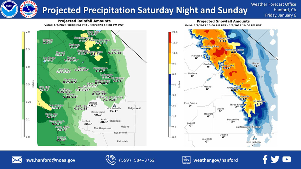
Mariposa, Saturday through Sunday Projected Precipitation: 1.00" to 1.50"
Oakhurst, Saturday through Sunday Projected Precipitation: 1.00" to 1.50"
Yosemite Valley, Saturday through Sunday Projected Precipitation: 1.00" to 1.50"
January 6, 2023 - The National Weather Service Hanford Office reports the next storm system will impact Central California Saturday night and Sunday, resulting in snow in the Sierra Nevada above 5,000 feet and rain in most of the San Joaquin Valley.
A much stronger storm system will impact Central California early next week.
Area Forecast Discussion
National Weather Service Hanford CA
252 AM PST Fri Jan 6 2023
.SYNOPSIS...
For today, calmer weather will prevail ahead of the next low
pressure system that is set to arrive on Saturday and continue
until Sunday. Another major storm is expected on Monday into
Wednesday.
&&
.DISCUSSION...Calm conditions have set in; however, patchy dense
fog has already developed in the San Joaquin Valley. We issued a
Dense Fog Advisory until 10 AM for these areas. Expect a brief
break from precipitation before yet another low pressure system
arrives on Saturday. Mainly light precipitation is expected
through the day on Saturday, but intensity will pick up by
Saturday night. Thus, we have issued a Winter Storm Watch for the
Sierra Nevada above 6,000 feet and a Flood Watch for most areas
below 6,000 feet beginning Saturday night. Rain and mountain snow
continue until Sunday evening, with snow levels mainly around
5,000 feet on Saturday night into Sunday rising to around 6,000
feet by Sunday evening. Snow amounts with this next system will be
around one to two feet in the highest elevations. The next system
arrives early Monday morning with barely a break during Sunday
night.
This second storm will be much stronger and accompanied with
another robust atmospheric river that will produce more widespread
heavy rain with rising snow levels. Snow levels on Monday into
Monday night will rise to around 8,000 feet before lowering again
late Monday night into Tuesday with the passage of the cold front.
Gusty southerly winds will likely occur ahead of the cold front
on Monday through the day and into the evening; however, winds do
not appear as strong as with the previous one. For example, there
is a 20 percent chance of a 45 mph gust on the Grapevine from
Monday night into Tuesday morning. Precipitation will continue
into much of Tuesday, and there may be another opportunity for
post-frontal convection by Tuesday afternoon. Rain and mountain
snow will taper off late Tuesday night into early Wednesday
morning.
It appears we'll get a decent break from storms on Wednesday into
Thursday. Ensemble guidance shows the next low pressure system
arriving late Thursday with precipitation chances into next
Friday.
The Climate Prediction Center continues to show above average
precipitation in our forecast area for the 8-14 day outlook. Their
latest 8-14 day hazards outlook now shows a moderate to high risk
of heavy precipitation for next Friday until the following
Sunday, so the very active regime continues.
&&
.AVIATION...
MVFR conditions with areas of IFR in low clouds in the southern
Sierra Nevada and Tehachapi Mountains, as well as the adjacent
foothills and valley facing slopes through this morning. IFR
conditions with areas of LIFR/patchy VLIFR in the San Joaquin
Valley due to mist and fog until 18Z Friday. Otherwise, VFR
conditions will prevail for the next 24 hours.
&&
.AIR QUALITY ISSUES...On Friday January 6 2023, Fireplace/Wood
Stove Burning Status is: No Burning Unless Registered in Fresno
and Kern Counties. Burning Discouraged in Kings, Madera, Merced,
and Tulare Counties, and Kern (Greater Frazier Park Area) and
Sequoia National Park and Forest.
&&
.CERTAINTY...
The level of certainty for days 1 and 2 is high.
The level of certainty for days 3 through 7 is high.
Certainty levels include low...medium...and high. Please visit
www.weather.gov/hnx/certainty.html for additional information
and/or to provide feedback.
&&
.HNX WATCHES/WARNINGS/ADVISORIES...
Flood Watch from late Saturday night through late Tuesday night
for CAZ300>325-327-329>336-338.
Dense Fog Advisory until 10 AM PST this morning for CAZ301-302-
305>307-309>312.
Winter Storm Watch from Saturday evening through late Tuesday
night for CAZ323-326>330.
Source: NWS
