


Includes Mariposa and Madera Counties
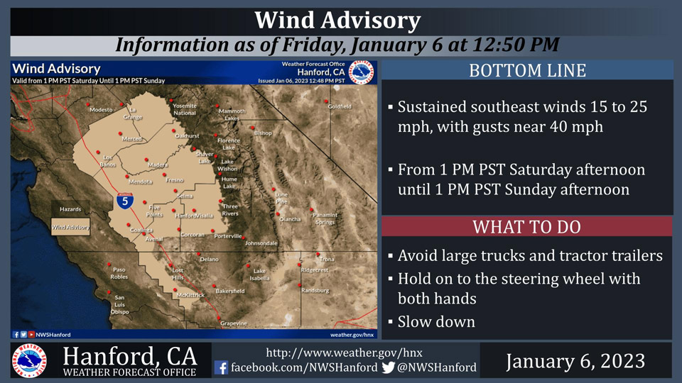
January 6, 2023 - The National Weather Service Hanford Office reports a Wind Advisory is in effect for the northern and central portion of the San Joaquin Valley and Coastal Range from 1:00 P.M. Saturday afternoon until 1:00 P.M. Sunday afternoon.
Travel will be difficult, particularly for high profile vehicles, such as campers and tractor trailers.
Highways affected include, but are not limited to Interstate 5, Highway 33, Highway 152 through Pacheco Pass, Highway 198 west of Lemoore, and Highway 180 west of Fresno.
Area Forecast Discussion
National Weather Service Hanford CA
138 PM PST Fri Jan 6 2023
.SYNOPSIS...
For today, calmer weather will prevail ahead of the next low
pressure system that is set to arrive on Saturday and continue
until Sunday. Another major storm is expected on Monday into
Wednesday.
&&
.DISCUSSION...
Patchy dense shallow fog developed around Hanford and Merced this
morning and burned off rather quickly. We can expect some patchy
fog again tonight and will let the later shifts to decide on a
DFA or not. Models were bringing in clouds earlier on Saturday
which could mitigate widespread fog development in the SJV.
A new system is forecast to move in Saturday with winds increasing
mainly Fresno county north late on Saturday. Precipitation is
also forecast to move into the FA around the same time and will
spread south through the day ans the cold front pushes through.
Moderate rain is expected overnight on Saturday and will be
gradually tapering off by Sunday midday. There will be a brief
break in the precip late on Sunday and into Sunday night. Rain
fall amounts will be around a half an inch near Merced to only a
trace in Bakersfield. So the first system will not be as strong
as the previous storms we have been seeing. Snow line will start
out around 5000 feet Saturday night and rise to 6000 feet by
Sunday night. Snow amounts are expected to be around 6 to 18
inches with around 2 feet above 8000 feet.
There is going to a very brief break in between storm systems of
only 6 to 12 hours. A second and significantly stronger storm is
forecast to move into the forecast area (FA) starting late Sunday
night and continuing through Tuesday evening. The second system
will be more of an atmospheric river event. This means it will be
tapping into sub tropical moisture and will raise snow levels from
6000 feet to above 8000 feet by Monday night. Very heavy amounts
of precipitation is expected with the second system. We are
looking at rainfall amounts in the SJV for the event to range from
nearly 2.5 inches near Merced to around 0.75 inches in
Bakersfield. Rainfall amounts will be from 2 to 4 inches below
4000 feet and 3 to 6 inches in the Sierra foothills below the snow
line of 8000 feet. Snow amounts above 8000 feet are expected to be
3 to 6 feet with isolated amounts up to 8 feet above 10000 feet
in elevation. We are concerned about heavy rain on snow below
8000 feet and possible flooding concerns Monday night. Snow
levels will begin to drop to around 6000 feet again by late
Tuesday morning and the rain will switch back over to snow before
ending on Tuesday night.
We will see a break on Wednesday and most of Thursday to allow
water to reside and see some drying out. Fog in the SJV will once
again become a concern Wednesday night and possibly Thursday
night. A weak system will pass to our north on Thursday night and
Friday providing a chance of precip mainly north of Kern county.
Area creeks, streams and rivers are expected to rise across the
region with Bear Creek along the Merced river forecast to go into
flood stage. Confidence is low on this happening, but is still
noteworthy.
&&
.AVIATION...
MIFR conditions with areas of LIFR/patchy VLIFR in the San
Joaquin Valley due to mist and fog until 18Z Saturday. VFR
conditions with areas of IFR in low clouds in the southern
Sierra Nevada and Tehachapi Mountains, as well as the adjacent
foothills and valley facing slopes through tomorrow night.
Otherwise, VFR conditions will prevail for the next 24 hours.
&&
.AIR QUALITY ISSUES...
ISSUED: 01/05/2023 15:04
EXPIRES: 01/06/2023 23:59
On Friday January 6 2023,Fireplace/Wood Stove Burning Status is:
No Burning Unless Registered in Fresno and Kern Counties. Burning
Discouraged in Kings, Madera, Merced, and Tulare Counties, and
Kern (Greater Frazier Park Area) and Sequoia National Park and
Forest.
&&
.CERTAINTY...
The level of certainty for days 1 and 2 is high.
The level of certainty for days 3 through 7 is medium.
Certainty levels include low...medium...and high. Please visit
www.weather.gov/hnx/certainty.html for additional information
and/or to provide feedback.
&&
.HNX WATCHES/WARNINGS/ADVISORIES...
Flood Watch from late Saturday night through late Tuesday night
for CAZ300>325-327-329>336-338.
Wind Advisory from 1 PM Saturday to 1 PM PST Sunday for
CAZ300>308-311>313-317>320.
Winter Storm Warning from 10 PM Saturday to 4 AM PST Wednesday
for CAZ323-326>330.
Source: NWS
