


Includes Mariposa, Madera Counties and Yosemite
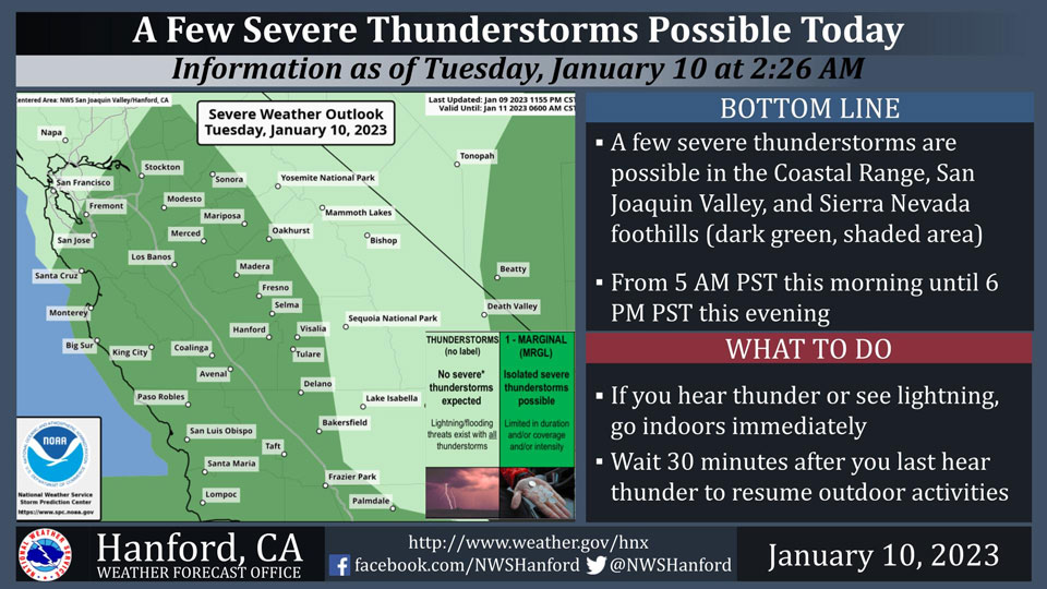
January 10, 2023 - The National Weather Service Hanford Office reports a few severe thunderstorms are possible in the Coastal Range, San Joaquin Valley, and Sierra Nevada foothills today.
The primary thunderstorm hazards will be locally damaging wind gusts of 58 mph or higher and perhaps a brief tornado.
In addition to dangerous cloud to ground lightning strikes, any thunderstorm can produce small hail and intense rainfall rates, leading to localized flooding.
Area Forecast Discussion
National Weather Service Hanford CA
200 AM PST Tue Jan 10 2023
.SYNOPSIS...A strong storm system will continue through this
evening, bringing periods of moderate to heavy rain and high
elevation snow along with gusty winds. Drier weather is likely on
Wednesday and Thursday. Another storm system will move into the
area by the end of the week for another round of wet weather.
&&
.DISCUSSION...The heavy precipitation that impacted our area on
Monday has tapered off, but not before shattering several daily
climatological rainfall records for January 9. Radar composites
are showing some light showers over the Sierra Nevada at this
time with Mesowest indicating the snow level running between 7500
and 8000 feet.
Meanwhile, another round of moderate to heavy precipitation is
approaching the cencal coast and is progged to reach our area by
later this morning and provide our area with more rain and higher
elevation snow. QPF progs are showing between a quarter and three
quarters of an inch of additional rainfall for the San Joaquin
Valley, 1 to 3 inches of additional rain in the Sierra foothills
and 2 to 4 inches of additional liquid precipitation over the
Sierra Nevada. Ahead of the precipitation, some gusty southerly
winds will remain possible across the West Side Hills and over the
Grapevine area and along the valley facing slopes of the
Tehachapi Mountains.
The incoming precipitation is associated with a cold frontal
boundary which will push through our area during the late morning
and early afternoon and provide our area with a colder and
unstable airmass. Instability and CAPE will be favorable for
thunderstorms this by this afternoon as the HRRR is showing LI/s
this afternoon between -4 and -2 Deg C across most of the San
Joaquin Valley with CAPES between 400 and 800 J/KG. SPC convective
outlook is indicating a marginal risk of severe thunderstorms
across the entire San Joaquin Valley as well as over the West Side
Hills and portions of the Sierra foothills and Tehachapi
Mountains today. As the cold front pushes through our area, the
snow level is progged to plunge to around 4000 feet over Yosemite
Park to around 5000 feet near the Grapevine.
SREF showing a shortwave trough pushing through the PAC NW and
Norcal on Wednesday which might bring some light precipitation to
our area mainly from Fresno County northward on Wednesday
afternoon and evening. A shortwave ridge builds in on Thursday
which will bring drier weather to our area through early Friday.
Areas of fog will be possible in the San Joaquin Valley on
Thursday and Friday mornings if enough clearing takes place. The
NBM is now forecasting another parade of low pressure systems to
move through our area between Saturday and the middle of next
week providing us with more rain and higher elevation snow.
&&
.AVIATION...In the San Joaquin Valley, West Side Hills and
Sierra foothills, areas of MVFR and local IFR conditions in low
clouds and rain thru 06Z Wed. Isolated thunderstorms until 03Z
Wed. In the Sierra Nevada and Tehachapi Mountains, widespread
mountain obscuring IFR conditions in low clouds and precipitation.
In the Kern County Deserts, local MVFR conditions in rain between
18Z Tue and 24Z Tue.
&&
.AIR QUALITY ISSUES...On Tuesday January 10 2023, Fireplace/Wood
Stove Burning Status is: Burning Discouraged in Fresno, Kern,
Kings, Madera, Merced, and Tulare Counties, and Kern (Greater
Frazier Park Area) and Sequoia National Park and Forest.
&&
.CERTAINTY...
The level of certainty for days 1 and 2 is high.
The level of certainty for days 3 through 7 is medium.
Certainty levels include low...medium...and high. Please visit
www.weather.gov/hnx/certainty.html for additional information
and/or to provide feedback.
&&
.HNX WATCHES/WARNINGS/ADVISORIES...
Flood Watch through late tonight for CAZ300>325-327-329>336-338.
Winter Storm Warning until 4 AM PST Wednesday for CAZ323-326>330.
Source: NWS
