


Updated on Friday Morning: Winter Storm Warning Begins Saturday Morning for the Sierra Nevada from Yosemite National Park (Outside of the Valley) to Sequoia National Park
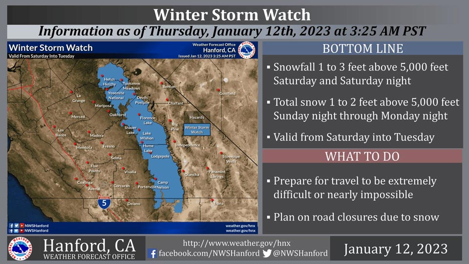
January 13, 2023 - The National Weather Service Hanford Office reports a Winter Storm Watch is in effect for the Sierra Nevada from Saturday into Tuesday.
A Winter Storm Watch means there is potential for significant snow accumulations that may impact travel.
The majority of this snow will fall Saturday afternoon and Saturday evening.
Travel could be extremely difficult or impossible. If you plan to travel, consider alternate strategies.
If you must travel, remember to carry tire chains, plenty of food, a good deal of water, warm clothing, and a flashlight in your vehicle.
Winter Storm Watch
URGENT - WINTER WEATHER MESSAGE
National Weather Service Hanford CA
603 AM PST Thu Jan 12 2023

Yosemite NP outside of the valley-Upper San Joaquin River-
Kaiser to Rodgers Ridge-Kings Canyon NP-Grant Grove Area-
Sequoia NP-South End of the Upper Sierra-
Including the cities of Tuolumne Meadows, Wawona,
Devils Postpile, Florence Lake, Lake Thomas Edison, Lake Wishon,
Huntington Lake, Shaver Lake, Cedar Grove, Grant Grove,
Hume Lake, Giant Forest, Lodgepole, and Johnsondale
603 AM PST Thu Jan 12 2023

...WINTER STORM WATCH REMAINS IN EFFECT FROM LATE FRIDAY NIGHT
THROUGH TUESDAY AFTERNOON...

* WHAT...Heavy snow possible. Total snow accumulations of 1 to 2
  feet possible for Saturday into Sunday and another 1 to 2 feet
  for Sunday night into Tuesday.

* WHERE...Sierra Nevada from Yosemite to Tulare County at
  elevations around 5,000 feet, although snow levels will drop
  to around 4,000 feet on Sunday.

* WHEN...From late Friday night through Tuesday afternoon.

* IMPACTS...Travel could be very difficult to impossible. The
  hazardous conditions could impact the morning or evening
  commute.

PRECAUTIONARY/PREPAREDNESS ACTIONS...
Source: NWS
