


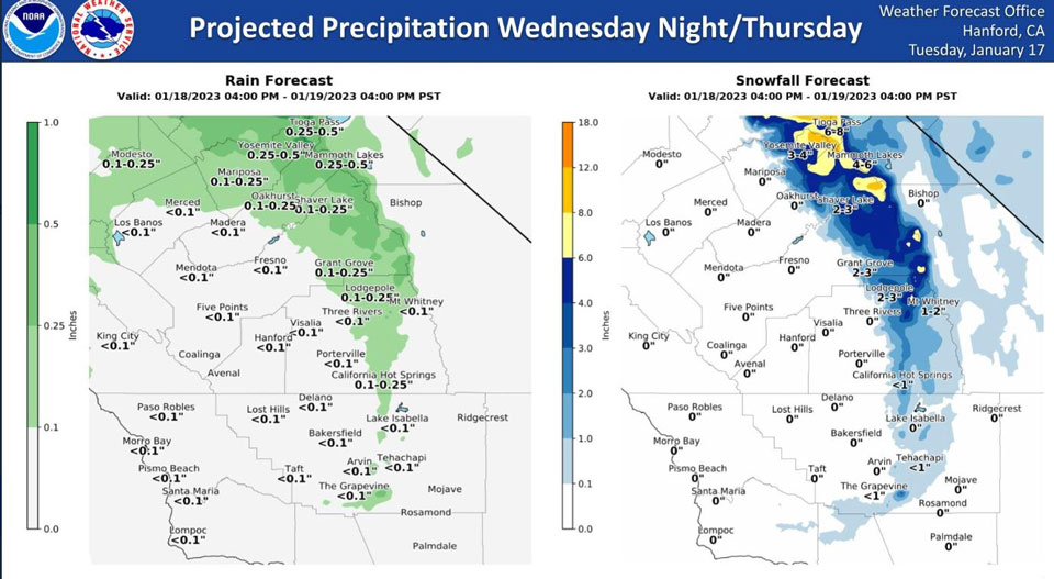
Projected Precipitation for Mariposa 0.10"- 0.25"
Projected Precipitation for Oakhurst 0.10"- 0.25"
Projected Precipitation for Yosemite Valley 0.25"- 0.50"
January 17, 2023 - The National Weather Service Hanford Office reports projected precipitation for the next storm to hit Central California.
While most of the district will see light rain or snow, an area from Yosemite to Huntington Lake and Mono Hot Springs may see significant new snowfall.
Area Forecast Discussion
National Weather Service Hanford CA
1249 PM PST Tue Jan 17 2023
.SYNOPSIS...
A small trough will pass through Wednesday night to
Thursday morning. Otherwise, a cooler but drier pattern will
prevail. Fog possible most mornings this week and around 40 to 50
percent chance of freezing temperatures this weekend.
&&
.DISCUSSION...
As the latest trough that brought the storms that
ended very early this morning slides away, another trough will
start to slide in Wednesday night into Thursday. In the
transition between the two troughs tonight, there will be
subsidence or sinking air present tonight in conjunction with the
moisture from all the recent rain will provide a favorable
environment for fog to develop. The GEFS and European model
ensembles are in agreement of the trajectory of the next trough
to slide through the Nevada side of the Sierra Nevada. This trough
will be bring light rain to the Valley but strong wind gusts up
in the Sierra Nevada up to 45 MPH. Latest probabilistic models
have between 30 and 45 percent chance of a tenth of an inch or
more on Wednesday night into Thursday for Fresno County and north
while the Valley south of Fresno County only having 20 percent
chance or less of a tenth of an inch of rain from this system
Both ensembles are in strong agreement in showing the building of
a ridge off the coast of California which will provide subsidence
and cold polar air into our area starting Thursday afternoon and
evening after the last trough slides away. The ridge will provide
for clearer skies. However, the afternoon highs will persist in
the upper 40s to low 50s for most of the Valley through the
weekend and into early next week. The ridge also will provide
enough subsidence for fog for the Valley. Probabilistic models
have between 40 and 55 percent chance of temperatures at or below
freezing Friday and Sunday mornings with the urban areas of
Bakersfield and Fresno being the exceptions. For Saturday morning,
most of the Valley will have between 50 and 70 percent chance of
temperatures at or below freezing with Bakersfield and Fresno
again being the exceptions.
&&
.AVIATION...
VFR conditions with some areas of MVFR and IFR
possible for most of the afternoon due to low clouds and mist.
MVFR and IFR conditions possible in the mountains due to clouds
and the showers especially for the Tehachapi Mountains and the
Grapevine. IFR and LIFR conditions start to happen from around 08Z
tomorrow until 18Z due to fog for most of the Valley.
&&
.AIR QUALITY ISSUES...
ISSUED: 01/16/2023 14:34
EXPIRES: 01/17/2023 23:59
On Tuesday January 17 2023,Fireplace/Wood Stove Burning Status is:
Burning Discouraged in Fresno, Kern, Kings, Madera, Merced, and
Tulare Counties, and Kern (Greater Frazier Park Area) and Sequoia
National Park and Forest.
&&
.CERTAINTY...
The level of certainty for days 1 and 2 is high.
The level of certainty for days 3 through 7 is medium.
Certainty levels include low...medium...and high. Please visit
www.weather.gov/hnx/certainty.html for additional information
and/or to provide feedback.
&&
.HNX WATCHES/WARNINGS/ADVISORIES...
Winter Weather Advisory from 4 PM Wednesday to 10 AM PST
Thursday for CAZ323-326.
Source: NWS
