


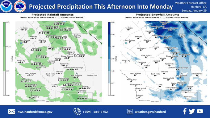
Projected Precipitation for Mariposa 0.10"- 0.25"
Projected Precipitation for Oakhurst 0.10"- 0.25"
Projected Precipitation for Yosemite Valley 0.10"- 0.25"
Yosemite Valley today: Snow likely, mainly after noon. Increasing clouds, with a high near 37. Wind chill values as low as 17. West wind 5 to 10 mph becoming light and variable. Winds could gust as high as 15 mph. Chance of precipitation is 60%. Total daytime snow accumulation of 1 to 3 inches possible.
January 29, 2023 - The National Weather Service Hanford Office reports a storm system will impact Central California this afternoon into Monday, resulting in a chance of rain in the San Joaquin Valley and light snow in the Sierra Nevada and adjacent foothills.
The majority of this precipitation will fall this afternoon and this evening.
Area Forecast Discussion
National Weather Service Hanford CA
1243 AM PST Sun Jan 29 2023
.SYNOPSIS...
There is a chance of rain in the San Joaquin Valley and light
snow in the Sierra Nevada and adjacent foothills this afternoon
into Monday. Snow showers are possible over Kern County mountain
passes tonight and Monday. Sub-freezing temperatures are
conceivable in the San Joaquin Valley each night and early
morning from late Monday night until Thursday morning.
&&
.DISCUSSION...
A trough of low pressure will move southward into Northern
California today. A cyclone aloft should develop in the base of
this trough tonight as it passes through the service area. The
upper-level area of low pressure will pivot eastward Monday. As a
result, there is a chance of rain in the San Joaquin Valley and
light snow in the Sierra Nevada and adjacent foothills this
afternoon into Monday. Rain amounts, in any, in the San Joaquin
Valley will be generally less than one tenth of an inch. Snow
levels in the Sierra Nevada foothills will start at around 3,000
feet this afternoon, before falling to about 2,000 feet tonight.
Snow amounts will be an inch or less from 2,000 feet to 3,000
feet. Snow accumulations will be one to three inches from 3,000
feet to 4,000 feet. Snow amounts will be three to five inches
above 4,000 feet.
Snow showers are possible above 2,500 feet along Interstate 5 over
Tejon Pass and along Highway 58 over Tehachapi Pass tonight and
Monday. The best chance of accumulating snowfall will be from 10
PM PST tonight until 10 AM PST Monday morning. One to two inches
of snow is conceivable, which could cause travel delays and/or
road closures. If you must travel, allow plenty of time to reach
your destination.
A ridge of high pressure will move eastward over the Eastern
Pacific Ocean Monday night and Tuesday. This ridge of high
pressure should make landfall over the west coast of the United
States Tuesday night. The ridge of high pressure should amplify as
it progress eastward across the Western United States Wednesday
through Thursday. The tail end of a trough of low pressure could
clip the northern portion of the forecast area Thursday night into
Friday. This is a low probability, low impact scenario. A Freeze
Watch is in effect for the San Joaquin Valley each night and early
morning from late Monday night into Thursday morning due to the
possibility of sub-freezing temperatures. Here are probabilities
of minimum temperatures of 32 degrees or lower for locations in
the San Joaquin Valley on Tuesday, January 31st, 2023:
Merced - 84%
Madera - 79%
Hanford - 69%
Lemoore - 69%
Visalia - 64%
Porterville - 64%
Reedley - 64%
Delano - 59%
Fresno - 54%
&&
.AVIATION...
MVFR visibilities, with local IFR visibilities, are likely in the
San Joaquin Valley this morning due to mist. MVFR conditions are
possible in and near showers this afternoon and tonight.
&&
.AIR QUALITY ISSUES...
On Sunday, January 29th, 2023, fireplace/wood stove burning status
is: no burning unless registered in Fresno, Kern, Kings, Madera,
Merced, and Tulare Counties. Burning discouraged in Kern (Greater
Frazier Park Area) and Sequoia National Park and Forest.
&&
.CERTAINTY...
The level of certainty for days 1 and 2 is medium.
The level of certainty for days 3 through 7 is medium.
Certainty levels include low, medium, and high. Please visit
www.weather.gov/hnx/certainty.html for additional information
and/or to provide feedback.
&&
.HNX WATCHES/WARNINGS/ADVISORIES...
Wind Advisory until 4 PM PST this afternoon for CAZ337>339.
Freeze Watch from late Monday night through Thursday morning for
CAZ301>303-305>307-309>312-314>316.
Winter Weather Advisory from 3 PM this afternoon to noon PST
Monday for CAZ334-335.
Source: NWS
