


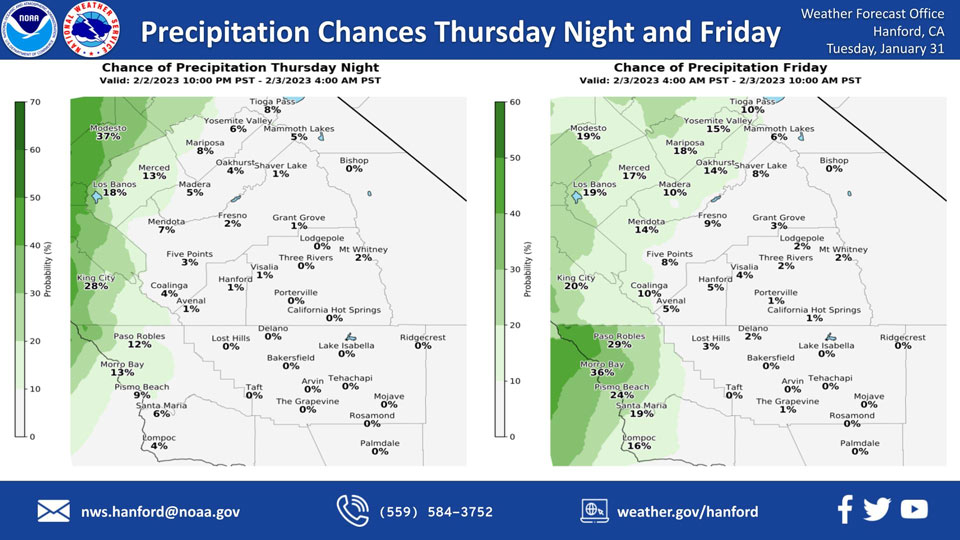
Projected Precipitation Chances for Mariposa for Thursday Night: 8% and Friday: 18%
Projected Precipitation Chances for Oakhurst for Thursday Night: 4% and Friday: 14%
Projected Precipitation Chances for Yosemite Valley for Thursday Night: 6% and Friday: 15%
January 31, 2023 - The National Weather Service Hanford Office reports the tail end of a trough of low pressure may clip the northern portion of our service area Thursday night into Friday, resulting in a slight chance of light precipitation north of Fresno County.Snow levels will start at around 4,000 feet Thursday night, before rising to about 5,000 feet Friday.
This is considered a low probability, low impact event.
Area Forecast Discussion
National Weather Service Hanford CA
152 AM PST Tue Jan 31 2023
.SYNOPSIS...Cold temperatures and dry conditions will prevail
across the region through Wednesday with sub-freezing morning lows
across the San Joaquin Valley, before moderating later this week.
A weak storm system may bring precipitation to the area on
Sunday.
&&
.DISCUSSION...In the wake of the cold winter storm which brought
light precipitation to much of our area on Monday, a drier
airmass is slowly pushing southward into our area. Fog imagery is
indicating some low clouds are banked up along the south end and
east side of the San Joaquin Valley as well as over the valley
facing slopes of the Tehachapi Mountains and the Sierra Foothills
in Tulare County. A few patches of fog have been observed in the
center portion of the San Joaquin Valley, but with the direr
airmass continuing to push into our area do not expect widespread
dense fog this morning.
The main concern for our area through Wednesday will be sub-
freezing minimum temepratures in the San Joaquin Valley as most
rural locations in the valley are expected to have lows in the
upper 20s today and near 30 DEG F on Wednesday. A Freeze Warning
remains in effect for the San Joaquin Valley until 900 am PST
Wednesday. Some airmass moderation is expected to take place later
in the week as the latest NBM probabilistic guidance is
indicating that most the the San Joaquin Valley has a less than 10
percent chance of sub-freezing morning temperatures on Thursday.
The medium range ensemble means are still indicating a pair of
troughs moving eastward through the PAC NW and Norcal later on in
the period. The first one will bring a slight chance of
precipitation to Merced County and the Yosemite Park area
Thursday night and Friday. Shortwave ridging will follow on
Friday night and Saturday before a strong system moving north of
our area brings a chance of precipitation to areas north of Kern
County Saturday night and Sunday. A cooler and drier airmass is
progged to build into our area early next week behind the second
system.
&&
.AVIATION...In the San Joaquin Valley areas of MVFR in low clouds
and mist with local IFR/LIFR in mist/fog from Fresno County
southward until 18Z Tue. In the Sierra foothills south of Fresno
County, areas of MVFR in low clouds and mist with local IFR/LIFR
in mist/fog until 21Z Tue. Otherwise, VFR conditions will prevail
across the central CA interior for the next 24 hours.
&&
.AIR QUALITY ISSUES...On Tuesday January 31 2023, Fireplace/Wood
Stove Burning Status is: No Burning Unless Registered in Fresno,
Kern, and Madera Counties. Burning Discouraged in Kings, Merced,
and Tulare Counties, and Kern (Greater Frazier Park Area) and
Sequoia National Park and Forest.
&&
.CERTAINTY...
The level of certainty for days 1 and 2 is medium.
The level of certainty for days 3 through 7 is medium.
Certainty levels include low...medium...and high. Please visit
www.weather.gov/hnx/certainty.html for additional information
and/or to provide feedback.
&&
.HNX WATCHES/WARNINGS/ADVISORIES...
Freeze Warning until 9 AM PST Wednesday for CAZ301>303-305>307-
309>312-314>316.
Source: NWS
