


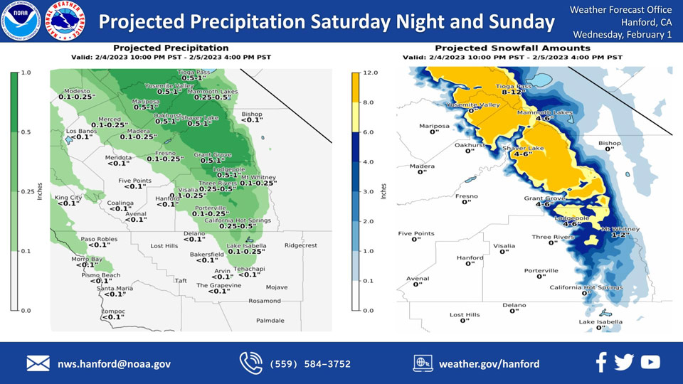
Projected Precipitation for Mariposa for Saturday Night Through Sunday: 0.50" to 1.00".
Projected Precipitation for Oakhurst for Saturday Night Through Sunday: 0.50" to 1.00".
Projected Precipitation for Yosemite Valley for Saturday Night Through Sunday: 0.50" to 1.00".
February 1, 2023 - The National Weather Service Hanford Office reports the next storm system will impact Central California Saturday night and Sunday, resulting in a chance of snow in the Sierra Nevada and a chance of rain in the San Joaquin Valley.Snow levels will start at around 6,000 feet Saturday night, before dropping to about 5,000 feet Sunday.
The majority of this precipitation will fall Saturday night.
Area Forecast Discussion
National Weather Service Hanford CA
1229 AM PST Wed Feb 1 2023
.SYNOPSIS...
Dense fog will develop in the central and southern portions of the
San Joaquin Valley this morning. The tail end of a trough of low
pressure may clip Merced and Mariposa Counties Thursday night
into Friday. The next storm system will impact Central California
Saturday night and Sunday, resulting in a chance of snow in the
Sierra Nevada and a chance of rain in the San Joaquin Valley.
&&
.DISCUSSION...
Dense fog will form in the central and southern parts of the San
Joaquin Valley this morning. Visibilities in dense fog will range
from 800 feet to 200 feet. Highways affected include, but are not
limited to Highway 43, Interstate 5 south of Lost Hills, Highway
99 south of Selma, Highway 198 from Visalia to Lemoore, Highway 41
from Kettleman City to Caruthers, and Highway 58 from Bakersfield
to Buttonwillow. If driving, slow down, use low beam headlights,
and keep plenty of distance between your vehicle and the vehicle
in front of you.
A ridge of high pressure will amplify as it progress eastward
across the Western United States tonight and Thursday. The tail
end of a trough of low pressure could clip Merced and Mariposa
Counties Thursday night into Friday, resulting in a slight chance
of precipitation. A ridge of high pressure will move eastward
across the Western United States Friday night and Saturday. The
next storm system will impact Central California Saturday night
and Sunday. Snow levels in the Sierra Nevada will start at around
6,000 feet Saturday night, before falling to about 5,000 feet
Sunday. Snow accumulations of six to twelve inches are possible in
the Sierra Nevada above 7,000 feet. Snowfall of three to six
inches is conceivable in the Sierra Nevada from 5,000 feet to
7,000 feet.
Rain amounts will be one tenth of an inch or less in the majority
of the San Joaquin Valley, although a few locations in the
eastern portion of the San Joaquin Valley could see rain amounts
of one tenth of an inch to one quarter of an inch Saturday night
and Sunday. Here are probabilities of rain amounts of one tenth of
an inch or more for select locations in the San Joaquin Valley
from 4 PM PST Saturday, February 4th until 4 PM PST Sunday,
February 5th, 2023:
Merced - 46%
Fresno - 36%
Reedley - 36%
Madera - 31%
Visalia - 21%
Hanford - 16%
Porterville - 16%
Lemoore - 16%
Delano - 11%
Bakersfield - 2%
High pressure will build eastward across California Sunday night
through Tuesday, resulting in dry weather.
&&
.AVIATION...
Dense fog localized in the central valley may cause IFR/LIFR
conditions during tonight and into the next morning, from around 2
AM until around 11 AM. VIS, MCE, and MER are very likely to enter
IFR/LIFR conditions during this time. It is less likely that FAT
and BFL will enter IFR/LIFR conditions, though some models
indicate the possibility of dropping to IFR/LIFR conditions. VFR
conditions are expected to return across the central valley after
12 PM and continue for the rest of the day.
&&
.AIR QUALITY ISSUES...
On Wednesday, February 1st, 2023, fireplace/wood stove burning
status is: no burning unless registered in Fresno, Kern, Kings,
Madera, Merced, and Tulare Counties. Burning discouraged in Kern
(Greater Frazier Park Area) and Sequoia National Park and Forest.
&&
.CERTAINTY...
The level of certainty for days 1 and 2 is medium.
The level of certainty for days 3 through 7 is medium.
Certainty levels include low, medium, and high. Please visit
www.weather.gov/hnx/certainty.html for additional information
and/or to provide feedback.
&&
.HNX WATCHES/WARNINGS/ADVISORIES...
Freeze Warning until 9 AM PST Wednesday for CAZ301>303-305>307-
309>312-314>316.
Dense Fog Advisory until 11 AM PST Wednesday for CAZ302-303-
305>307-309>312-315.
Source: NWS
