


Updated at 1:35 P.M. Friday Afternoon:
Winter Storm Watch Upgraded to a Winter Storm Warning - Begins Saturday Evening for the Sierra Nevada from Yosemite National Park (Outside of the Valley) to Sequoia National Park
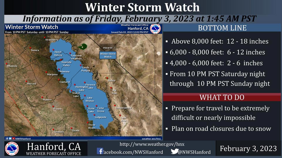
February 3, 2023 - The National Weather Service Hanford Office reports a Winter Storm Watch is in effect for the Sierra Nevada from 10:00 P.M. Saturday night through 10:00 P.M. Sunday night.
A Winter Storm Watch means there is potential for significant snow accumulations that may impact travel.
Snow levels will start at around 6,500 feet Saturday night, before dropping to about 4,000 feet by Sunday evening. The majority of this snow will fall late Saturday night through Sunday morning.
Winds may gust as high as 55 mph on exposed ridgetops and near the crest.
Travel could be extremely difficult or impossible. If you plan to travel, consider alternate strategies.
If you must travel, remember to carry tire chains, plenty of food, a good deal of water, warm clothing, and a flashlight in your vehicle.
Winter Storm Watch
URGENT - WINTER WEATHER MESSAGE
National Weather Service Hanford CA
335 AM PST Fri Feb 3 2023

CAZ323-325>330-032000-
/O.CON.KHNX.WS.A.0004.230205T0600Z-230206T0600Z/
Yosemite NP outside of the valley-San Joaquin River Canyon-
Upper San Joaquin River-Kaiser to Rodgers Ridge-Kings Canyon NP-
Grant Grove Area-Sequoia NP-
Including the cities of Tuolumne Meadows, Wawona,
Devils Postpile, Florence Lake, Lake Thomas Edison, Lake Wishon,
Huntington Lake, Shaver Lake, Cedar Grove, Grant Grove,
Hume Lake, Giant Forest, and Lodgepole
335 AM PST Fri Feb 3 2023

...WINTER STORM WATCH REMAINS IN EFFECT FROM SATURDAY EVENING
THROUGH SUNDAY EVENING...

* WHAT...Heavy snow possible. Total snow accumulation of 12 to 18
  inches with locally higher amounts to near 2 feet will be
  possible. Winds could gust as high as 55 mph.

* WHERE...Sierra Nevada from Yosemite to Sequoia National Park.
  Snow levels around 6,500 feet on Saturday evening lowering to
  4,500 feet by Sunday afternoon.

* WHEN...From Saturday evening through Sunday evening.

* IMPACTS...Travel could be very difficult to impossible. Gusty
  winds could bring down tree branches.

PRECAUTIONARY/PREPAREDNESS ACTIONS...

Monitor the latest forecasts for updates on this situation.
Source: NWS
