


California and National Drought Summary for February 14, 2023
Summary
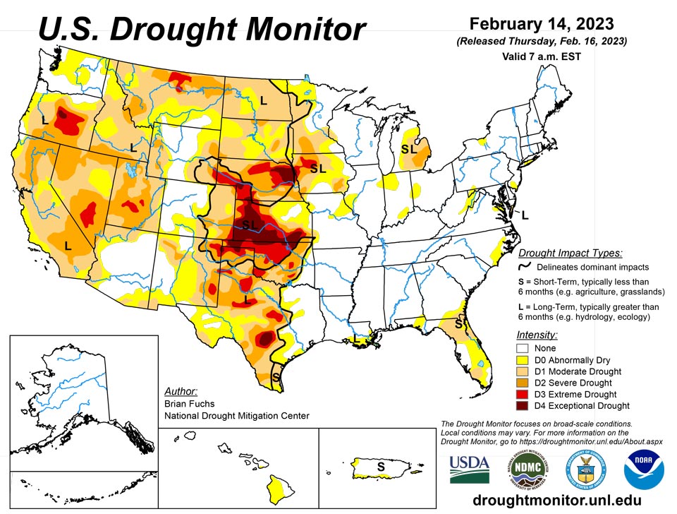
February 16, 2023 - An active weather week over much of the South, Southeast and portions of the Midwest allowed many locations in eastern Oklahoma, northern Arkansas, central Mississippi, northern Florida, southern Georgia and into coastal areas of South Carolina to record above-normal precipitation. Dry conditions dominated the West and northern Plains. Temperatures were well above normal in the northern Plains and upper Midwest, with departures of 15-20 degrees above normal. Most areas east of the Missouri River were above normal for the week with departures of 5-15 degrees above normal common. Cooler-than-normal temperatures dominated the intermountain West and into the Four Corners region where temperatures were 5-10 degrees below normal for the week.
Northeast
Temperatures for this week were 9-12 degrees above normal over the region and precipitation was isolated to northern extents along the Great Lakes and Canadian border and to the south in Virginia. Currently, drought is not an issue in the region, with only one small area of moderate drought along the Virginia coast. Abnormally dry conditions were expanded this week over western Maryland and into southern Pennsylvania. Several pockets of dryness were being monitored in the region for potential degradation soon.
Southeast
Precipitation was isolated in the region, with portions of south Florida, northern Georgia and Alabama being the driest in the region with below-normal precipitation. The greatest precipitation was recorded from north Florida northward along the coast into the Carolinas where over 200% of normal rain was observed. The recent precipitation allowed for severe drought to be removed from all of Florida and Georgia and for some improvements to moderate drought and abnormally dry conditions in both states. North Florida did see an expansion of moderate drought where the rains missed and conditions continued to be dry in the short term. A new area of moderate drought was also introduced in south Florida based on the short-term dryness of the region. Improvements were made in both North Carolina and South Carolina in response to the recent wet pattern where all abnormal dryness was removed from South Carolina and moderate drought was removed and abnormally dry conditions improved in North Carolina. A small area of abnormally dry conditions was also improved in southern Alabama.
South
Precipitation was widespread throughout most of eastern Oklahoma, northern Texas, northern Arkansas and portions of southern Louisiana with most of these areas recording 150-200% of normal precipitation for the week. Temperatures were warmest in the eastern extent where Arkansas and Louisiana were 4-6 degrees above normal while most of Oklahoma and Texas were 2-4 degrees below normal. The recent wetter pattern allowed for most of eastern Oklahoma to observe a full category improvement to the drought intensities with abnormally dry conditions removed from the eastern extent and some exceptional drought improved as well. Areas of eastern Texas had improvements made to moderate drought and abnormally dry conditions but saw degradations, mainly on long-term indicators highlighting the changes over portions of the panhandle, central and south Texas.
Midwest
An active storm pattern through Missouri and into Illinois and Michigan was the focus of the widespread precipitation through this portion of the region. Areas of the upper Midwest as well as the eastern extent of the region were quite dry for the week. In the storm track, most areas were well above normal for weekly precipitation and some recorded over 400% of normal for the week. Temperatures for the week were well above normal for the entire region with areas of the upper Midwest 12-16 degrees above normal. The active weather over some of the drought areas allowed for improvements this week. Most of Missouri had a full category improvement with just some lingering moderate drought in the southwest and in the far northwest corner of the state. Abnormally dry conditions were removed from southern Illinois and improvements were made in western and northern portions of the state. Southern portions of Iowa also saw enough improvement in the indicators to show improved conditions. The region was also being impacted by widespread precipitation after the data cutoff for this week, and this new information will be analyzed in the next map.
High Plains
Temperatures for the week were warmest over the eastern and northern extent of the region with departures 10-15 degrees above normal while the western areas were 5-10 degrees below normal in portions of Wyoming and Colorado. Most of the region was dry this week with the exception of eastern Kansas where over 200% of normal precipitation was recorded for the week. As temperatures warmed up and the benefits of the snowpack over portions of southern South Dakota and northern Nebraska started to be observed, improvements were made this week to the drought intensity levels along the South Dakota and Nebraska borders. A full category improvement was also made to conditions in eastern Kansas where more moderate drought was eliminated and improvements to severe and extreme drought were made in southeast portions of the state. Some slight degradation was introduced in Wyoming where severe drought was expanded in the east and southwest portions of the state.
West
Cooler-than-normal temperatures dominated most of the region outside of Montana where temperatures were 15-20 degrees above normal for the week. Most of the region was dry with only portions of New Mexico, southern Colorado, southern Montana and portions of the Pacific Northwest recording above-normal precipitation. Snowpack over the region remains well above normal. With the continued wet pattern over the Southwest, portions of Arizona and New Mexico were improved this week with moderate drought and abnormally dry conditions reduced in both states. Drier conditions in Washington allowed for some expansion of abnormally dry conditions while a reassessment of the extreme drought in northwest Nevada determined that conditions had improved enough to remove all of the extreme drought in this region.
Caribbean
No changes were made this week in Puerto Rico.
Most of the U.S. Virgin Islands have remained in drier-than-normal conditions. The satellite data (i.e., National Weather Service’s seven-day quantitative precipitation estimates) and station observations show that the rainfall amount received over most parts of the islands was less than 0.4 inches. The one- and three-month Standardized Precipitation Index (SPI) maps showed that conditions have been significantly dry at St. Thomas and St. Croix. However, St. John was in relatively near-normal condition.
Specifically, St. John (Rafe Boulon/Windswept Beach) reported 0.33 inches of rain this week. The depth to water level at Susannaberg DPW 3 well (St. John, USVI) on February 14 was 10.94 ft below land surface. Even though there has been a decreasing trend in water since November 2022, the depth to water level at Susannaberg DPW 3 well is relatively lower than it was September to November 2022, resulting in a near-normal condition, so St. John remains at the status quo of drought-free conditions.
St. Croix (Henry Rohlsen AP) reported 0.27 inches of rain this week. The depth to water level at Adventure 28 Well (St. Croix, USVI) on February 14 was 28.16 ft below land surface. The analysis showed a significant decrease in water level (about 3 ft) since November 17, when it was 25.27 ft below land surface. Reports also showed that the wintertime precipitation on St. Croix is below normal and is the eighth driest in 64 years of data. This week’s 3-month SPI also confirms St. Croix is in at least moderate drought.
No rain was reported on St. Thomas (Cyril E. King Airport) this week. There was also an increase in depth to water level at St. Thomas. The depth to water level at Grade School 3 well (St. Thomas, USVI) on February 14 was 9.51 ft below land surface. Thus, St. Thomas remained in short-term moderate drought (D1-S) this week.
Pacific
No changes were made this week in Alaska.
In Hawaii, a wet trade wind pattern continued, which enabled the windward side of the Big Island to recover from their drought issues back in January. One producer on the east side of the Big Island reported that his catchment tank is full. Streamflow values from across the state are near to above normal at nearly all sites for the 7-, 14- and 28-day periods. Conditions are expected to remain wet as a low-pressure system is forecast to bring significant rainfall later this week. The remaining abnormally dry conditions were removed from Molokai and most of the rest of the abnormally dry conditions were removed from Maui. On the Big Island, the east side of the island had some abnormally dry conditions removed because of above-normal rainfall.
Heavy rains were observed across the Marshall Islands this week. Because of the wet conditions this week, Ailinglapalap and Majuro improved to be free of abnormal dryness. This week, Ailinglapalap received 3.07 inches of rain. Similarly, 7.02 inches of rain was reported on Majuro, allowing the island to be free of drought. Jaluit received 3.64 inches of rain and remained drought free. On Mili, 10.93 inches of rain was reported this week, allowing Mili to be drought free. This week, Wotje reported no rain (two days missing). Dry conditions continued the past four weeks at Wotje (i.e., 0.7, 0.68, 0 and 1.30 inches of rain, consecutively), and the island remains in short-term abnormally dry condition. Similarly, Kwajalein reported only 0.18 inches of rain and remains in abnormally dry condition. No depiction was made for Utirik due to missing data.
American Samoa remained free of drought this week. Pago Pago and Toa Ridge (NPS in American Samoa) received 0.86 and 1.58 inches of rain, respectively. With one day missing, Siufaga Ridge (NPS in American Samoa) reported 1.46 inches of rain. Palau IAP (Airai) reported 4.43 inches this week. Koror COOP station also reported 3.37 inches of rain, resulting in drought-free conditions.
Most parts of the Federated States of Micronesia remained drought free this week. Only Kapingamarangi, which received 1.26 inches of rain this week, remained in long-term abnormally dry condition. On Fananu, 1.76 inches of rain was reported this week, but the island remained free of drought or abnormal dryness because of the significant amounts of rain in January. On Kosrae, 4.84 inches of rain was reported this week (with three days missing), allowing the island to remain drought free. On Lukunor, only 0.28 inches of rainfall was reported this week (with five days missing). Wet conditions were observed in January (10.45 inches of rain). Thus, Lukunor remains drought free. On Nukuoro, 2.81 inches of rain was reported this week (three days missing), allowing the island to be free of drought or abnormal dryness. Only 0.47 inches of rain was reported on Pingelap with six days missing. However, due to the wet conditions that prevailed in the past few weeks, Pingelap remained drought free. On Yap, only 1.68 inches of rain was reported this week. However, because of wet conditions in January, Yap remained free of dryness. On Ulithi, only 0.64 inches of rain was reported this week (one day missing). Even though dry conditions were reported in the past two weeks (i.e., 0.72 and 0.26 inches of rain, respectively), Ulithi received about 14 inches of rain in January, allowing the island to remain drought free. On Woleai, 3.51 inches of rain was reported this week (one day missing), so it remains drought free. This week, 4.10 inches of rain was reported on Pohnpei with three days missing, so the island remained free of dryness. At Chuuk, 14.24 inches of rain was reported this week with one day unaccounted for, allowing the island to be free of dryness.
This week, drier-than-normal conditions continued across the Mariana Islands. Rainfall amounts on Guam and Rota were 0.82 and 0.74 inches (one day missing), respectively. In addition, dry conditions prevailed in the past two weeks across the islands. However, due to the wet January, the island remained free of dryness or drought. The amounts of rainfall observed on Saipan (IAP, manual gauge), Saipan (ASOS) and Saipan (NPS) were 0.23, 0.19 and 0.31 inches, respectively. Thus, Saipan remains drought free this week.
Looking Ahead
Over the next 5-7 days, a storm system will track out of the Four Corners region and onto the Plains, bringing with it widespread precipitation from Colorado, through the Plains and into the Midwest. Widespread precipitation is also expected throughout the South and into the Mid-Atlantic where up to 2-3 inches of rain is anticipated. Much of the southern and northern Plains as well as the West will be dry during this time. Temperatures are expected to be above normal over much of the southern Plains, Midwest and eastward with departures of 8-10 degrees above normal. Cooler-than-normal temperatures are expected over the central to northern Plains, and over the West where departures of up to 15 degrees below normal will be expected over Wyoming.
The 6–10 day outlooks show above-normal chances of below-normal temperatures over the northern Rocky Mountains, the Pacific Northwest and much of the West. The best chances of above-normal temperatures will be over the Southeast and through much of the South and Mid-Atlantic. Most of the country is showing above-normal chances of recording above-normal precipitation with the best chances over the Great Basin and in the Mid-Atlantic. South Texas and the peninsula of Florida are still showing a better likelihood of below-normal precipitation.
Author(s):
Brian Fuchs, National Drought Mitigation Center
Tsegaye Tadesse, National Drought Mitigation Center
Dryness Categories
D0 Abnormally Dry—used for areas showing dryness but not yet in drought, or for areas recovering from drought.
Drought Intensity Categories
D1 Moderate Drought
D2 Severe Drought
D3 Extreme Drought
D4 Exceptional Drought
Drought or Dryness Types
S Short-term, typically less than 6 months (agriculture, grasslands)
L Long-term, typically more than 6 months (hydrology, ecology)
SL Area contains both short- and long-term impacts
Source: National Drought Mitigation Center
