


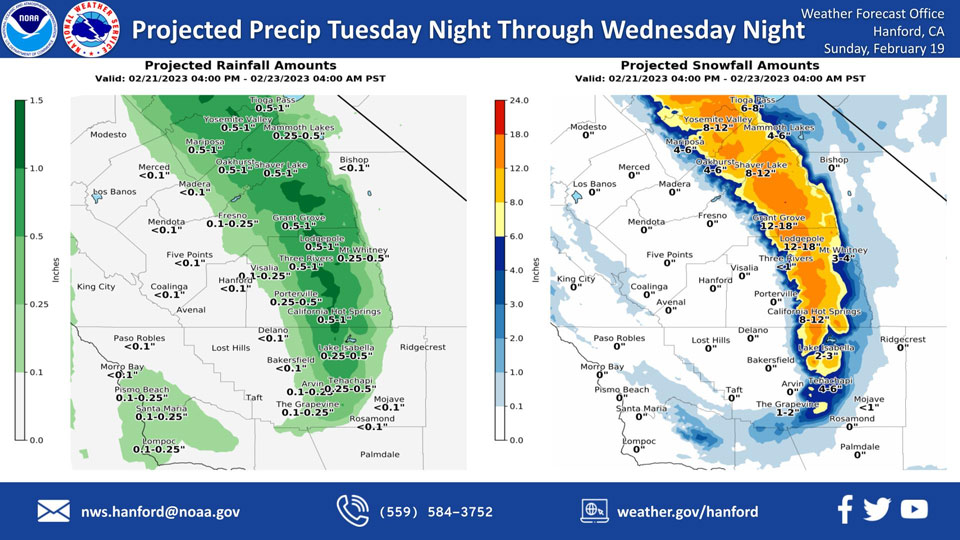
Projected Precipitation for Mariposa, Oakhurst and Yosemite Valley: 0.50" to 1.00"
February 19, 2023 - The National Weather Service Hanford Office reports the first in a series of cold storm systems next week will impact Central California Tuesday night through Wednesday night, resulting in low elevation snow in the Sierra Nevada foothills and a chance of rain in the San Joaquin Valley.
Snow levels will start at around 5,000 feet Tuesday night, before dropping to about 1,000 feet Wednesday.
The majority of this precipitation will fall Tuesday night.Area Forecast Discussion
National Weather Service Hanford CA
229 AM PST Sun Feb 19 2023
.SYNOPSIS...
Dry and calm conditions will prevail for our area this weekend
into Tuesday. Starting Tuesday night, there will be chances of
rain for the valley and snow for the Sierra Nevada range. These
chances will be greatest Tuesday night and into Wednesday. There
will also be chances for rain and snow going into Thursday and
Friday, and will taper off by Saturday afternoon. It is also
likely there will be 30 to 40 mph sustained winds and 60 mph wind
gusts down in the Kern County desert. There is currently a High
Wind Watch for that area from Tuesday at 10 AM to Wednesday at 10
AM.
&&
.DISCUSSION...
An upper level ridge extended into the Northeast Pacific continues
to influence our CWA while a weak upper level trough spins off the
west coast. By this afternoon, a weak ridge will settle into our
CWA, and it will stay there into Tuesday, which will slightly
increased temperatures for our CWA. However, there may be
overnight frost for the San Joaquin Valley as low temperatures
remain near freezing.
A deep upper level trough will dive down into our area Tuesday
night, which will mostly affect the Sierra Nevada mountains and
the foothills, while also bringing chances for light rain in some
of the eastern San Joaquin Valley. This will prevail into
Wednesday, where snow levels could drop as low as 1000ft,
affecting the foothills more. The newest model guidance suggests
Mariposa could receive 2-3 inches of snow, while Oakhurst could
receive 3-4 inches. The I-5 and Highway 58 passes may also receive
snowfall, which would impact those highways and may close them.
The I-5 pass may receive 1-2 inches of snow, while the Highway 58
may receive 3-4 inches.
This system may also bring strong winds to the Kern County desert
area, models show there may be sustained winds from 30 to 40 mph
and wind gusts of up to 60 mph. A High Wind Watch has been issued
for this area from Tuesday at 10 AM to Wednesday at 10 AM. This
would be hazardous to drivers, especially for high profile
vehicles. The highways affected include, but are not limited to:
Highway 14, Highway 58, US Highway 395, and Highway 178. This may
change to a High Wind Warning as confidence increases.
A secondary system will follow going into Thursday and Friday
that will keep precipitation chances up, mostly for the Sierra
Nevada mountains and foothills, and some chances for light rain in
the valley. Mariposa and Oakhurst are projected to receive 4-6
inches of snow. The I-5 and Highway 58 passes will continue to be
affected as well, with snowfall for the I-5 projected to be 3-4
inches of snow while Highway 58 is projected to receive 1-2
inches.
Chances for rain and snowfall are expected to drop off starting
Saturday morning and our CWA will return to dry conditions.
Temperatures will have cooled down significantly as a result of
the low pressure systems, with temperatures in the low 50's on
Wednesday and Thursday for the valley. Temperatures will slowly
start to increase as the systems move out of our CWA, and may be
in the mid to high 50's by next weekend. Nighttime lows may be
around freezing as well, with around 60% to 80% chance of some
locations in the valley reaching 32 degrees or below on Saturday.
&&
.AVIATION...
VFR conditions will prevail across the central valley for the next
24 hours.
&&
.AIR QUALITY ISSUES...
ISSUED: 02/18/2023 12:00
EXPIRES: 02/19/2023 23:59
On Sunday February 19 2023, Fireplace/Wood Stove Burning Status
is: No Burning Unless Registered in Fresno, Kern, Kings, and
Madera Counties. Burning Discouraged in Merced and Tulare
Counties, and Kern (Greater Frazier Park Area) and Sequoia
National Park and Forest.
&&
.CERTAINTY...
The level of certainty for days 1 and 2 is medium.
The level of certainty for days 3 through 7 is medium.
Certainty levels include low...medium...and high. Please visit
www.weather.gov/hnx/certainty.html for additional information
and/or to provide feedback.
&&
.HNX WATCHES/WARNINGS/ADVISORIES...
High Wind Watch from Tuesday morning through Wednesday morning
for CAZ337>339.
Source: NWS
