


California and National Drought Summary for April 25, 2023
Summary
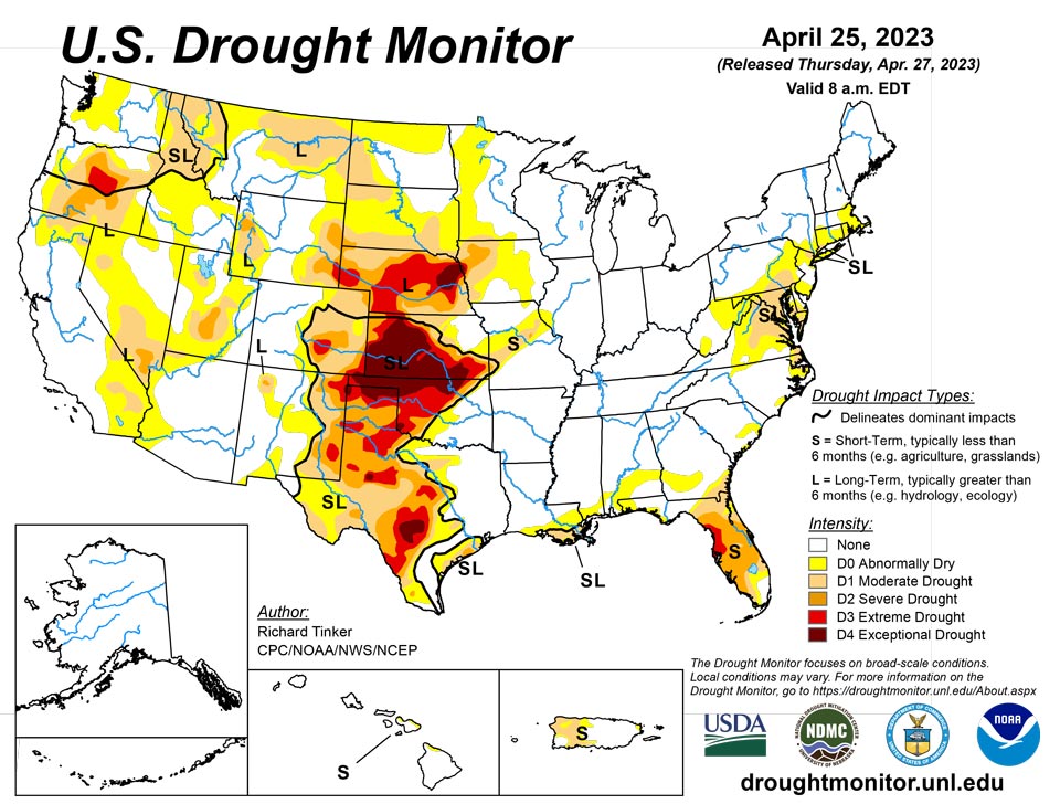
April 27, 2023 - Heavy precipitation fell on areas of dryness in the Northeast, the southern and northern Plains, the northern Rockies, northern Intermountain West, and Pacific Northwest, and more-scattered areas in the mid-Atlantic Region and Florida. Enough rain fell on some extant areas of dryness and drought here to improve drought designations, including parts of the D3 and D4 areas in central to southern Texas. In contrast, the D3 to D4 areas in the rest of the Plains and the northwestern Florida Peninsula and recorded little or no precipitation, keeping extreme to exceptional drought in place with a few areas of deterioration, especially in central Nebraska and the northwestern Florida Peninsula.
Northeast
Moderate to heavy rains (1.5 inches or more) fell on areas of dryness and drought in southern New England and the adjacent Northeast, and over patches of the coastal mid-Atlantic Region. The largest amounts (3 to 4 inches) doused parts of Massachusetts and Connecticut. This prompted improvements over parts of the coastal DelMarVa Peninsula and the wetter areas of the Northeast and southern New England, but precipitation in many areas of these areas remains significantly below normal over the past 2 to 3 months, so improvement was not as widespread as might be expected.
Abnormal dryness (D0) expanded across southern and eastern Massachusetts, which missed out on the precipitation, and in parts of eastern Pennsylvania and West Virginia. The National Interagency Coordination Center reports almost 13,500 acres consumed by wildfires across roughly the northeastern quarter of the contiguous states during April 14 through 20.
Southeast
Scattered patches of heavy rain were observed in the eastern Carolinas and the southern and eastern parts of the Florida Peninsula. This allowed drought and dryness to continue slowly improving in part of southern and eastern Florida, especially south and east of Lake Okeechobee. Small, isolated areas of improvement were also noted in the easternmost Carolinas and far southeastern Virginia.
Little or no rain fell elsewhere, with most locations reporting less than one-quarter inch. The induced some small areas of intensification in southern Georgia and northern Florida. But most areas from central Alabama northeastward through central North Carolina and southwestern Virginia remained free of any dryness on the Drought Monitor, though some short-term deficits (three weeks or fewer) were emerging in a few areas. The National Interagency Coordination Center reported nearly 15,000 acres were consumed by wildfires April 14 through 20.
South
Locations from eastern Texas and Oklahoma eastward through Mississippi and Tennessee remained free of any designation on the Drought Monitor, though a number of areas reported that short-term dryness – on the order of a few weeks – was becoming noticeable over northern stretches of this area. Thus dryness and drought were again limited to areas near the Gulf of Mexico and over central and western sections of Texas and Oklahoma.
Heavy rain eased dryness-related impacts over much of central and southern Texas. Several inches of rain in eastern parts of Deep South Texas allowed for 2-category improvements, with much of the area going from D1 last week to no designation this week. Still, large areas of D3 and D4 remained over central and western parts of Texas and Oklahoma, with more limited reductions occurring in these areas. But enough rain fell to pull D4 out of Bexar County, Texas.
To the north and west of central Texas, little or no rain fell this past week to the 8 am EDT April 25 valid period of the Drought Monitor, keeping conditions essentially unchanged in most areas, though some degradation was noted in small sections in west-central and northern Texas. Most of the northern tier of Oklahoma remains entrenched in exceptional (D4) drought, in addition to a few scattered areas farther south. According to the Department of Agriculture, 63 percent of Oklahoma winter wheat was in poor or very poor conditions, as was 55 percent of Texas winter wheat.
Midwest
Most of the Midwest Climate Region remained free of dryness and drought, confined to areas from Minnesota southward through Missouri, plus a small patch in west-central Illinois. Declining conditions in Missouri and adjacent Iowa led to a broad expansion of moderate drought (D1) in a swath through the middle of Missouri, and a few smaller locales in adjacent areas. In contrast, moderate to heavy precipitation and significant snowmelt led to improvements from northern and western Iowa northward through southern Minnesota.
High Plains
The general pattern observed during the past few weeks continued. Unusually deep snowpack was melting in the central and northern Dakotas, leading to some improvements there, including the removal of all moderate drought (D1) from northern North Dakota.
In the Great Plains from central and western South Dakota southward through Kansas, the continued lack of substantial rainfall led to intensification over a relatively large part of these areas. In particular, D3 expanded through most of central Nebraska, and lesser expansion of D3 and D4 reported in central Kansas. To the west, conditions remained generally unchanged in eastern parts of Wyoming and Colorado, with deterioration (to D2) limited to a small area in southeastern Wyoming. In the other area of extant dryness and drought in western Wyoming – adjacent to Utah and Idaho - some areas saw improved conditions, as did states to the north and west.
The Department of Agriculture reported 62 percent of Kansas winter wheat in poor or very poor condition, as was 42 percent of Nebraska winter wheat. Only 7 percent of Colorado winter wheat was in very poor condition, but almost one-third of the rest of the state’s crop was in poor condition.
West
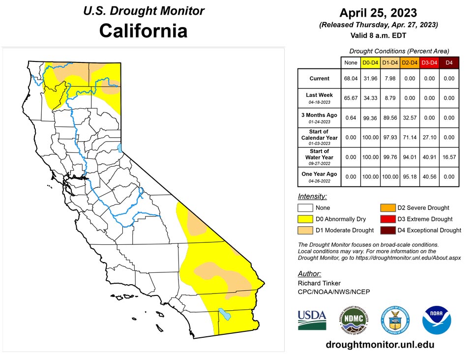
Areas of moderate to heavy precipitation brought some improvement across western Oregon and portions of Montana, while melting of the deep snowpack farther south eased conditions in parts of southeastern Idaho, much of the western half of Utah, northeastern Oregon, and small patches in the southern Great Basin and Southwest. This included the removal of moderate drought (D1) from parts of northern California, continuing the trend of improvement there since heavy precipitation became a frequent occurrence starting in early December 2022. The only area in the West Climate Region that noticeably deteriorated was some D0 expansion in southeastern Montana, where conditions have been similar to those in the central and southern High Plains Climate Region.
Caribbean
For the drought-monitoring period ending on April 25, occasional showers dotted the U.S. Virgin Islands. Seven-day rainfall totals at a variety of volunteer (CoCoRaHS) and airport stations ranged from 0.02 to 0.78 inch. Much of the rain fell late in the period, with King Airport on St. Thomas receiving 0.54 inch on April 22-23, and Rohlsen Airport on St. Croix reporting 0.50 inch on April 23-24. However, rainfall was insufficient to improve the drought designation, with St. Croix remaining in severe drought (D2) and St. Thomas remaining in moderate drought (D1). Abnormal dryness (D0) persisted on St. John. The drought depiction was supported by a variety of indicators, including the standardized precipitation index (at time periods ranging from 3 to 6 months); increasing depths to water at three U.S. Geological Survey wells; and poor vegetation health. On St. Croix, depth to water at the USGS Adventure 28 well topped 30 feet (on April 14) for the first time since late-October 2022.
Heavy rain (2 to locally 5 inches) fell on much of central and eastern Puerto Rico, and a few patches farther west over the extant drought area also received 2 inches or a little more. The impact this had on drought conditions in the Commonwealth was uncertain, as 1- to several-month precipitation totals remained below normal in many areas. After additional assessments, conditions here will be reevaluated next week.
Pacific
Alaska remained free of any impactful dryness.
Above-normal precipitation was reported across central Hawai’I, ending the state’s last remaining area of drought (D1) in northwestern Maui and reducing D0 coverage to that region. However, farther southeast, recent subnormal rainfall has induced some stress on parts of the northwestern Big Island, leading to the introduction of abnormal dryness there.
The remnants of Tropical Storm Sanvu passed through portions of the U.S.-Affiliated Pacific Islands, locally enhancing rainfall. During the drought-monitoring period ending on April 25, rainfall topped 4 inches at several observation sites in the Republic of the Marshall Islands (RMI) and the Federated States of Micronesia (FSM). Specifically in the RMI, 7-day rainfall totals reached 6.57 inches at Ailinglapalap and 5.98 inches at Kwajalein. Improvement from long-term moderate drought (D1-L) to abnormal dryness (D0-L) was noted for Kwajalein. Similarly, improvement from severe to moderate drought (D2-SL to D1-L) occurred on Wotje, RMI, with 5.78 inches of rain having fallen in the 2-week period ending April 25. However, showers largely bypassed Jaluit, RMI, which remained abnormally dry (D0-S); Jaluit has reported less than an inch of rain in 4 of the last 6 weeks.
In the FSM, Ulithi was the only location with a designation, remaining abnormally dry (D0-S). Ulithi has received less than 1.5 inches of rain in 5 consecutive weeks. Despite some patchy, short-term rainfall deficits emerging in a few locations across the western FSM, abnormal dryness was not yet warranted. Similarly, portions of the Republic of Palau have turned slightly drier, following an extended period of wet weather, with no need yet to introduce abnormal dryness.
Elsewhere, ample rain continued to fall across American Samoa, as well as most locations in the Marianas. Through April 25, month-to-date rainfall at Pago Pago International Airport in American Samoa totaled 13.57 inches. Many locations in the Marianas, including the airport sites on Guam and Saipan, received well-above-normal rainfall totaling more than 4 inches during the first 25 days of April.
Looking Ahead
During the next five days (April 26 – May 1, 2023) moderate to heavy precipitation (over 1.5 inches) is expected along the southern tier of the Nation from Texas and the lower Mississippi Valley through central and northern Florida, and along the Eastern Seaboard from Georgia through New England. Parts of the Upper Peninsula in Michigan are also forecast to receive 1.5 or more inches. Very heavy precipitation (3 to 5 inches) are expected in part of northeastern Texas, the central Gulf Coast Region, and southern Georgia. In contrast, little or nothing is anticipated from the High Plains westward, over the central and northern Great Plains, parts of the middle Mississippi Valley, and the southern Great Lakes Region. Moderate to locally heavy precipitation was observed from the Colorado Rockies through the south-central Great Plains and adjacent areas shortly after the Drought Monitor valid period (8 am EDT Tuesday, April 25) ended, with over 1.5 inches observed in scattered areas of central Arkansas, near the Oklahoma/Kansas border, west-central Kansas, higher elevations in the Rockies, and isolated sites across northern Texas. This precipitation will be considered for the Drought Monitor valid May 2, 2023 (next week). Other areas in dryness or drought should see one-tenth to locally one inch. Below-normal temperatures are expected over the southern Great Plains and most of the eastern half of the contiguous states outside the immediate coast in the South Atlantic Region. Meanwhile, warmer than normal weather is anticipated from most of the Plains through interior sections of the West Coast States. Cooler than normal conditions are expected along most of the immediate Pacific Coastline.
The Climate Prediction Center’s 6-10 day outlook (valid May 2 – 6, 2023) Identifies enhanced chances for above-normal precipitation in most of New England, the lower Mississippi Valley, Texas, the southern half of the High Plains, and from the Rockies to the Pacific Coast (except northwestern Washington). Odds for significantly above-normal precipitation exceed 50 percent in the Great Basin, most of California, and some adjacent areas. In contrast, subnormal totals are favored in the Southeast, the lower mid-Atlantic Region, and from the central and southern Appalachians northwestward through most of the Ohio Valley, Great Lakes Region, northern half of the Mississippi Valley, the northern Plains, and the Upper Midwest. Enhanced chances for cooler than normal weather cover California and adjacent areas in the Southwest and Great Basin, and in most locations from the Mississippi Valley to the East Coast. Meanwhile, unusually warm weather is expected from the northern Rockies and Intermountain West through most of the Rockies and the southern half of the High Plains.
Author(s):
Richard Tinker, NOAA/NWS/NCEP/CPC
Brad Rippey, U.S. Department of Agriculture
Dryness Categories
D0 Abnormally Dry—used for areas showing dryness but not yet in drought, or for areas recovering from drought.
Drought Intensity Categories
D1 Moderate Drought
D2 Severe Drought
D3 Extreme Drought
D4 Exceptional Drought
Drought or Dryness Types
S Short-term, typically less than 6 months (agriculture, grasslands)
L Long-term, typically more than 6 months (hydrology, ecology)
SL Area contains both short- and long-term impacts
Source: National Drought Mitigation Center
