


Includes Fresno, Merced, Madera and Mariposa Counties and Yosemite National Park
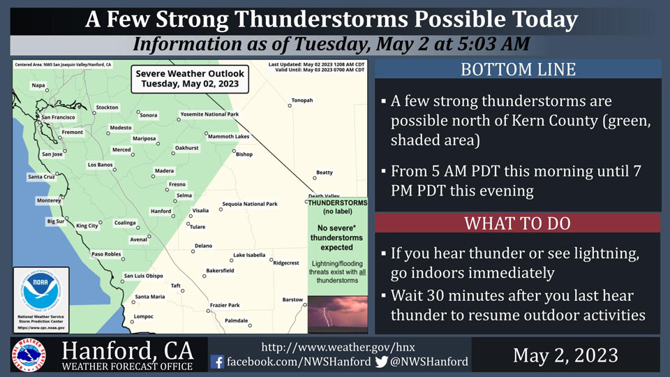
May 2, 2023 - National Weather Service officials report a few strong thunderstorms are possible north of Kern County today until 7:00 P.M. this evening.
Small hail and wind gusts near 45 miles per hour are a couple of hazards associated with strong thunderstorms.
In addition to dangerous cloud to ground lightning strikes, any thunderstorm can produce intense rainfall rates, leading to localized flooding.
When thunder roars, go indoors!
Area Forecast Discussion
National Weather Service Hanford CA
120 AM PDT Tue May 2 2023
.SYNOPSIS...
Cooler than average temperatures for the Valley with a warmup to
the mid to upper 70s expected over the weekend. Chance of showers
through Thursday for the Valley. Snow likely in the Sierra Nevada
through Saturday night above 5,000 feet.
&&
.DISCUSSION...
A trough started to move in yesterday bringing temperatures down to
10 to 15 degrees below average. In addition, the trough brought some
rain to the Valley with accumulation being reported here at the
forecast office in Hanford. This trough also brought gusty winds to
the Central Valley and Kern County Desert as a High Wind Advisory
for the Kern County Desert area expires at 5 AM this morning.
GEFS and European model ensembles are in agreement that the trough
in our area will persist for most of the week. However, the
ensembles diverge on Friday with regards to how the trough will
leave. The trough will persist in the area due to a strong ridge
over the Great Plains. Temperatures will climb back up through
the weekend but will still remain 5 to 10 degrees below average.
NBM 4.1 probabilistic models have between 45 and 70 percent chance
of high temperatures of at least 70 degrees of Friday for most of
the Valley with the exceptions being Bakersfield and Porterville
which will be around 30 percent.
The trough above the area is forecast to produce a few showers,
snow to the Sierra Nevada, and the possibility of thunderstorms due
to the instability with the colder temperatures that we will
experience after the major heat at the end of last week and during
the weekend. The NBM 4.1 also has between 20 and 40 chance of at
least a tenth of an inch of rain between 5 PM Wednesday and 5 PM
Thursday.
However, with snow levels hovering between 5,000 and 6,000 feet,
areas of higher snow melt may occur due to the effect of rain on
snow with the possible thunderstorms over the Sierra Nevada. This
potential additional snow melt would increase runoff into local
creeks and rivers which increases the risk of flooding.
&&
.AVIATION...
VFR conditions will prevail across the central California interior
for the next 24 hours.
&&
.AIR QUALITY ISSUES...
None.
&&
.CERTAINTY...
The level of certainty for days 1 and 2 is high.
The level of certainty for days 3 through 7 is medium.
Certainty levels include low...medium...and high. Please visit
www.weather.gov/hnx/certainty.html for additional information
and/or to provide feedback.
&&
.HNX WATCHES/WARNINGS/ADVISORIES...
Wind Advisory until 5 AM PDT early this morning for CAZ337>339.
Source: NWS
