


California and National Drought Summary for May 16, 2023
Summary
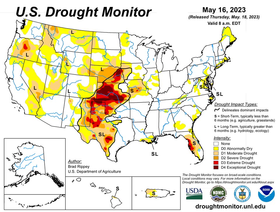
May 18, 2023 - A complex, slow-moving storm system delivered heavy rain across much of the nation’s mid-section, but largely bypassed some of the country’s driest areas in southwestern Kansas and western Oklahoma, as well as neighboring areas. Still, the rain broadly provided much-needed moisture for rangeland and pastures, immature winter grains, and emerging summer crops. Significant rain spread into other areas, including the southern and western Corn Belt and the mid-South, generally benefiting crops but slowing fieldwork and leaving pockets of standing water. Excessive rainfall (locally 4 to 8 inches or more) sparked flooding in a few areas, including portions of the western Gulf Coast region. Little or no rain fell across much of the remainder of the country, including southern Florida, the Northeast, the Great Lakes region, and an area stretching from California to the southern Rockies. Warmth in advance of the storm system temporarily boosted temperatures considerably above normal across parts of east-central Plains, western Corn Belt, and upper Great Lakes region. Meanwhile, record-setting heat developed in the Pacific Northwest, setting several May temperature records.
Northeast
With dry weather dominating areas from Pennsylvania and New Jersey northward, there was a focus on emerging dryness, especially in northern New England. In fact, abnormally dry conditions (D0) were introduced in much of northern and eastern Maine, as well as the northern tip of New Hampshire. On May 14, the U.S. Department of Agriculture reported that topsoil moisture was rated 39% very short to short in Maine, up from 29% the previous week. From March 1 – May 16, precipitation in northern Maine totaled just 3.97 inches (54% of normal) in Houlton and 4.12 inches (55%) in Caribou. Farther south, locally heavy showers dented abnormal dryness (D0) and moderate drought (D1) in West Virginia and western Maryland.
Southeast
There were only minor changes to the Southeastern drought depiction, amid spotty showers. Parts of Alabama and Virginia received beneficial rain, but abnormal dryness (D0) expanded in portions of the Carolinas. Central Florida remained a drought hotspot, with expansion of moderate to extreme drought (D1 to D3) noted. According to the U.S. Department of Agriculture, Florida led the region with statewide topsoil moisture rated 49% very short to short on May 14, followed by South Carolina at 34%. Parts of Florida continued to experience a significant risk of wildfire activity, with the Sandy Fire in Big Cypress National Preserve having burned nearly 20,000 acres of vegetation by mid-May. In recent days, Florida’s drought areas have endured extremely hot weather, with Naples reporting 5 consecutive days with 90-degree heat from May 11-15. Naples endured a month-long dry spell from April 17 – May 16, without a drop of rain during that period. Closer to the core drought area, Fort Myers experienced highs of 90°F or greater each day from May 5-16, including a daily record high of 96°F on the 15th. Through May 16, year-to-date rainfall totaled less than 4 inches in Florida locations such as Tampa (3.90 inches, or 34% of normal), Brooksville (3.52 inches, or 30%), St. Petersburg (2.21 inches, or 22%), and Naples (1.99 inches, or 23%). In stark contrast, year-to-date rainfall on the Atlantic Coast in Fort Lauderdale, Florida, totaled 37.33 inches (289% of normal).
South
Most of the region remained free of drought, but moderate to exceptional drought (D1 to D4) persisted in parts of central and western Texas and across the northwestern half of Oklahoma. During the drought-monitoring period, ending on the morning of May 16, extremely heavy rain drenched the western Gulf Coast region, especially near the central Texas coast. On May 10, Palacios, Texas, measured 6.21 inches of rain—part of a very wet stretch that included an additional 3.93 inches on May 13-14. Heavy showers extended northeastward into southeastern Oklahoma, northern Louisiana, Arkansas, and western Tennessee. By May 14, the U.S. Department of Agriculture reported that topsoil moisture was rated 30% surplus in Arkansas, along with 29% in Louisiana. Farther west, however, serious drought impacts persisted, despite spotty showers. Statewide in Texas, rangeland and pastures were rated 51% very poor to poor on May 14. Any rain was generally too late for the southern Plains’ winter wheat, which is quickly maturing. More than half of the wheat—52 and 51%, respectively, in Texas and Oklahoma—was rated very poor to poor by mid-May. A recent estimate by the U.S. Department of Agriculture indicated that 32.6% of the nation’s winter wheat will be abandoned—highest since 1917—including 70.1% of the Texas crop.
Midwest
Nearly all the region’s drought was confined to areas west of the Mississippi River, where pockets of heavy rain greatly reduced the coverage of abnormal dryness (D0) and moderate to extreme drought (D1 to D3). Some of the heaviest Midwestern rain fell across southern Minnesota, where D0 and D1 quickly turned to flooded fields amid May 10-14 rainfall totals that locally reached 4 to 8 inches or more. East of the Mississippi River, there were several patches of D0, mainly in Illinois, with a few other areas being watched due to a short-term drying trend.
High Plains
Phenomenal rainfall totals led to significant reductions in drought coverage, especially from eastern Colorado and northwestern Kansas into western North Dakota. Goodland, Kansas, received consecutive daily-record totals of 1.50 and 1.12 inches, respectively, on May 10 and 11. Daily-record totals topped 3 inches on the 11th in Imperial, Nebraska (3.56 inches), and Colorado Springs, Colorado (3.18 inches). That marked the wettest May day on record in Colorado Springs, toppling 2.34 inches on May 30, 1935. In Denver, Colorado, where 2.92 inches fell on the 11th, it was the wettest calendar day since May 6, 1973, when 3.27 inches fell. Denver’s storm total (4.40 inches from May 10-12) represented more than 30 percent of its normal annual precipitation. During the week ending May 14, the U.S. Department of Agriculture reported double-digit improvements in topsoil moisture rated very short to short in several states, including Nebraska (from 66 to 46%), South Dakota (from 38 to 19%), and Colorado (from 45 to 35%). The rain also helped to revive winter wheat and benefited emerging summer crops. Still, even with the rain, Kansas led the nation on May 14 with 68% of its winter wheat rated in very poor to poor condition. In addition, the rampant storminess largely bypassed some of the extreme to exceptional drought (D3 to D4) areas in a strip extending from southwestern Kansas into eastern Nebraska.
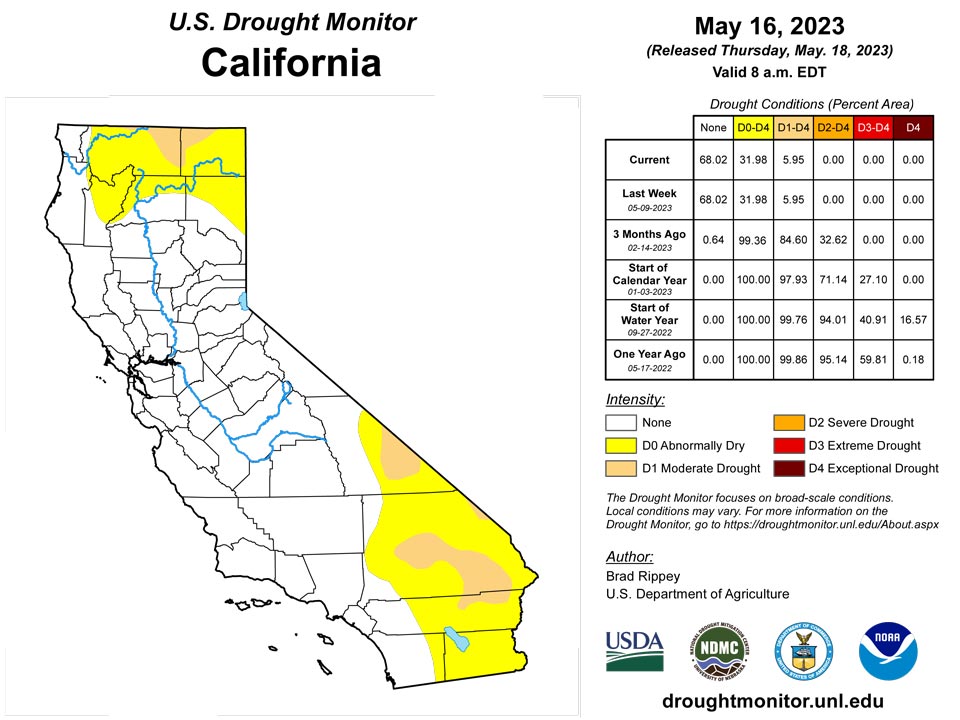
West
Aside from some heavy precipitation in the central Rockies and environs, much of the West experienced warm, mostly dry weather. As a result, there were only minor Western changes to the drought-depiction, some due to further assessment of the impact of cold-season precipitation as the snow-melt pace accelerated. Indeed, a Northwestern heat wave—rare for this time of year—resulted in multiple monthly record highs, starting on May 14. On that date in Oregon, both Astoria and Seaside attained 93°F. Astoria tied a monthly record, originally set on May 16, 2008, while Seaside toppled its monthly mark of 86°F, attained most recently on May 19, 1978. Notably, Portland, Oregon, achieved highs of 90°F or greater on 4 consecutive days, from May 12-15. Prior to this year, Portland’s May record of three 90-degree readings occurred in 1947 and 1987, with only the latter being observed on 3 consecutive days (May 6-8, 1987). Meanwhile in Washington, Hoquiam (91°F on the 14th) posted a monthly record high, shattering the standard of 87°F originally set on May 29, 2007. With a high of 92°F on the 14th, Quillayute, Washington, tied a monthly record first achieved on May 7, 1987. Elsewhere, Western reservoir storage as a percent of average for the date reflected varying degrees of drought recovery. As May began, California’s 154 primary intrastate reservoirs held 28.6 million acre-feet of water, 104 percent of average. However, storage on that date in the Colorado River basin was 15.5 million acre-feet, just 48 percent of average. Still, the surface elevation of Lake Mead has risen nearly 9 feet since setting an end-of month record low of 1,040.92 feet in July 2022.
Caribbean
In Puerto Rico, scattered to widespread showers provided limited relief in areas experiencing abnormal dryness (D0) and moderate drought (D1). D0 was removed from the northeastern corner of Puerto Rico, where there were some rainfall totals of at least 2 to 4 inches. Meanwhile, there were small D0 and D1 reductions in the west-central Puerto Rican highlands, where heavy rain was reported.
The U.S. Virgin Islands have trended drier. Weather observers indicate that St. Thomas received 0.66 inches or less, St. John received 0.89 inches or less, while St. Croix received mostly 0.04 inches or less on the western end of the island and 0.43 inches or less on the eastern end. Year to date percent of normal precipitation for the islands is 88.4% for St. John, 55.4% for St. Thomas and 45.0% for St. Croix.
Conditions have been sufficiently dry, however, for the Standardized Precipitation Index to show drought conditions on the one-, three- and six-month time scale for all islands. The values for St. Croix indicated extreme drought (D3-SL), an intensification of conditions from the previous week. The values for St. Thomas also indicate worsening drought conditions, so the island has been changed to severe drought (D2-S). St. John remains at moderate drought (D1-S). The wells’ depth to water level continued to increase with the dry conditions since the start of the year.
Pacific
The recently introduced area of abnormal dryness (D0) in south-central Alaska was eradicated by heavy precipitation. Kodiak received precipitation totaling 6.79 inches during the first 16 days of the month, with 4.42 inches falling from May 8-10. Farther north, significant ice-jam flooding occurred along portions of the Yukon and Kuskokwim Rivers. Notably, near-record flooding along the Yukon River affected the eastern Alaska community of Circle, where the water reportedly rose to its highest level since 1945.
There were no changes to the Hawaiian depiction, which continued to feature a small area of abnormal dryness (D0) and moderate drought (D1) along and near the north shore of the Big Island.
The Republic of Palau rainfall was below normal for the week with 0.35 inches at Palau IAP and 0.67 inches at Koror. Precipitation was ample last week, so water supplies should be adequate.
The Mariana Islands were all on the dry side. Saipan received 0.45 inches and was abnormally dry (D0). Rota reported 0.51 inches. Guam collected 0.20 inches in the rain gauge and was categorized as being abnormally dry this week. The first two weeks of May 2023 have been drier than any other two-week period so far this year. Vegetation has dried out slightly. These islands need an inch weekly to meet minimum water needs.
Precipitation for the Federal States of Micronesia was mixed with most locations receiving more than 2 inches of rain. Ulithi remained abnormally dry (D0) with 0.36 inches. Kosrae and Yap reported 1.37 and 0.83 inches of rain, respectively. Chuuk, Kapingamarengi and Pingelap received more than 2 inches of rain, with Nukuoro and Pohnpei receiving 8.30 and 6.19 inches, respectively.
The Marshall Islands were mostly below 2 inches of precipitation for the week, but received enough rain recently that water supplies should be adequate. The Majuro reservoir held 23.932 million gallons on May 12. Above normal rainfall in Jaluit last week allowed the removal of abnormal dryness (D0), leaving the Marshall Islands free of drought. Ailinglaplap, Jaluit, Kwajalein and Wotje received less than 0.55 inches, while Majuro and Mili received 3.01 and 4.36 inches, respectively.
American Samoa remained free of dryness. Pago Pago received 0.93 inches of rain, which is near the one inch needed to meet minimum water needs.
Looking Ahead
Showers and thunderstorms will linger for the next couple of days across the lower Southeast, in the vicinity of a weakening cold front, with an additional 1 to 3 inches of rain possible in some areas. Meanwhile, another cold front will race eastward across the northern U.S., generating showers before reaching the Atlantic Coast on Saturday. Rainfall associated with the Northern cold front will be short-lived, with most locations receiving less than an inch. However, late-week thunderstorms may become heavy along the tail of the cold front, with 1 to 3 inches of rain possible in central and southern sections of the Rockies and Plains. Elsewhere, little or no precipitation will fall during the next 5 days along and near the Pacific Coast. The NWS 6- to 10-day outlook for May 23 – 27 calls for the likelihood of near- or above-normal temperatures and precipitation across most of the country. Cooler-than-normal conditions will be confined to parts of the South, while drier-than-normal weather should be limited to the Pacific Northwest and an area stretching from the mid-South and lower Midwest into the Northeast.
Author(s):
Brad Rippey, U.S. Department of Agriculture
Denise Gutzmer, National Drought Mitigation Center
Dryness Categories
D0 Abnormally Dry—used for areas showing dryness but not yet in drought, or for areas recovering from drought.
Drought Intensity Categories
D1 Moderate Drought
D2 Severe Drought
D3 Extreme Drought
D4 Exceptional Drought
Drought or Dryness Types
S Short-term, typically less than 6 months (agriculture, grasslands)
L Long-term, typically more than 6 months (hydrology, ecology)
SL Area contains both short- and long-term impacts
Source: National Drought Mitigation Center
