


Includes Madera and Mariposa Counties including Oakhurst and Yosemite
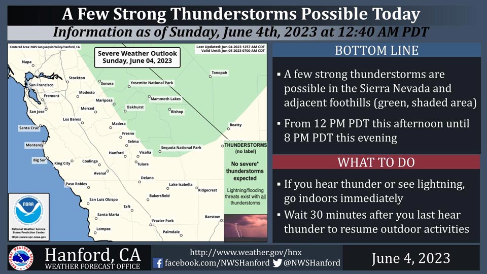
June 4, 2023 - National Weather Service Hanford Office officials report a few strong thunderstorms are possible in the Sierra Nevada and adjacent foothills from 12:00 P.M. this afternoon until 8:00 P.M.this evening.
Small hail and wind gusts near 45 miles per hour are a couple of hazards associated with strong thunderstorms.
In addition to dangerous cloud to ground lightning strikes, any thunderstorm can produce intense rainfall rates, leading to localized flooding.
Area Forecast Discussion
National Weather Service Hanford CA
1240 AM PDT Sun Jun 4 2023
.SYNOPSIS...
A warming trend is expected to continue today. This afternoon,
high temperatures will be around seven to ten degrees above
seasonal average. A few strong thunderstorms are possible this
afternoon and evening once again today in the Sierra Nevada and
adjacent foothills. A storm system will move over Southern
California beginning Monday that will provide at least a cooling
trend and increased winds in some areas.
&&
.DISCUSSION...
There is a high chance of readings in the mid 90's today in the
warmest locations, courtesy of a ridge of high pressure.
Probabilities are about 75 to 85 percent at quite a few areas,
such as in the Central Valley and eastern Kern County desert
areas. Chances of triple digits are not out of the question, as
probabilities are low, including a 25 percent probability at
Fresno and just shy of 20 percent at China Lake. Otherwise,
chances of a triple digit high temperature are less than 10
percent elsewhere. Nonetheless, today could be a bit uncomfortable
for quite a few folks in these warmest areas, including those
sensitive to the heat or just not used to it. By later today,
expect another chance for showers and isolated thunderstorms over
the Sierra Nevada. There is a low chance that another slow moving
storm with heavy rain could develop somewhere in the higher
elevations of the Sierra and cause a threat of flash flooding.
A cooling trend begins Monday as a closed upper-level low
pressure system approaches Southern California from the Eastern
Pacific. Chances for afternoon/evening showers and isolated
t'storms spread to the lower elevation locations and the Kern
County mountains on Monday and for the next day or two. Similar to
the last couple of model runs, there is about a 15 to 30 percent
chance that somewhere in the Central Valley could receive
measurable, or at least 0.01 inch, or rainfall on both Monday and
Tuesday. Breezy conditions develop in the typical prone areas,
such as the coastal ranges and the Mojave Desert slopes in Kern
County, which is typical this time of year whenever we get an
influx of cooler air.
Much cooler temperatures are in store for both Tuesday and
Wednesday, and highs will lower back to several degrees below
average. Highs will be in the lower 80's in much of the Central
Valley and the Kern County portion of the Mojave Desert during
this period. As the upper-level low lingers, there is a least a
moderate chance for more showers and thunderstorms for quite a few
areas.
Warming returns later in the week, or by Thursday, once the low
pressure system exits the region. Daytime highs will rise back to
mainly seasonal values through Friday. However, at least a slight
chance of Sierra thunderstorms continues for the higher
elevations through next weekend due to plenty of moisture and
melting snowpack. In addition, a weak trough pattern sets up over
the Golden State by Saturday, and this will prevent any
significant warming. Ensemble and deterministic guidance
continues to support this idea. Fortunately, we're not expecting
extended periods of excessive heat just yet.
&&
.AVIATION...
VFR conditions will prevail at all of the terminal aerodrome sites
through at least the next 24 hours. A chance of MVFR or lower
conditions near any thunderstorm in the Sierra Nevada and adjacent
foothills this afternoon and this evening.
&&
.AIR QUALITY ISSUES...
None.
&&
.CERTAINTY...
The level of certainty for days 1 and 2 is high.
The level of certainty for days 3 through 7 is medium.
Certainty levels include low...medium...and high. Please visit
www.weather.gov/hnx/certainty.html for additional information
and/or to provide feedback.
&&
.HNX WATCHES/WARNINGS/ADVISORIES...
None.
Source: NWS
