


Includes Madera and Mariposa Counties including Oakhurst and Yosemite
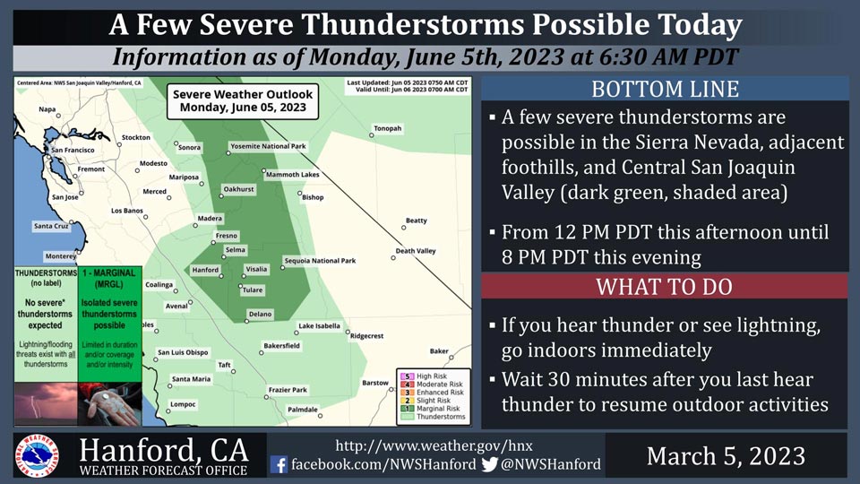
June 5, 2023 - National Weather Service Hanford Office officials report a few severe thunderstorms are possible in the Sierra Nevada, adjacent foothills, and Central San Joaquin Valley from 12:00 P.M. this afternoon until 8:00 P.M. this evening.
The primary thunderstorm hazards will be locally damaging wind gusts of 58 mph or higher and hail of around one inch in diameter.
In addition to dangerous cloud to ground lightning strikes, any thunderstorm can produce small hail and intense rainfall rates, leading to localized flooding.
Area Forecast Discussion
National Weather Service Hanford CA
1248 AM PDT Mon Jun 5 2023
.SYNOPSIS...
A low pressure system will impact Central California this
afternoon through Tuesday night, resulting in a chance of showers
and a slight chance of thunderstorms. A few thunderstorms may be
strong each afternoon and evening today and Tuesday. A cooling
trend is expected today and Tuesday. Temperatures will remain
below seasonal values Wednesday through Sunday.
&&
.DISCUSSION...
An upper-level area of low pressure will approach the southern
coast of California this afternoon. This cyclone aloft will make
landfall over Southern California tonight. The upper-level area of
low pressure will meander around the southern half of the Golden
State Tuesday and Tuesday night, before moving eastward Wednesday.
Westerly winds will increase this afternoon. Strong breezes are
possible this evening into tonight. A Wind Advisory may be
required for portions of Central California from late this
afternoon into tonight. A few strong thunderstorms are possible in
most of service area each afternoon and evening today and
Tuesday. Here are probabilities of rainfall amounts of 0.01
inches or more for select locations in the San Joaquin Valley from
5 PM PDT Monday, June 5th until 5 PM PDT Tuesday, June 6th, 2023:
Lemoore - 56%
Visalia - 46%
Hanford - 46%
Reedley - 46%
Porterville - 41%
Delano - 41%
Fresno - 36%
Bakersfield - 36%
Madera - 36%
Merced - 31%
A few strong thunderstorms are possible Wednesday afternoon and
Wednesday evening in the Sierra Nevada, adjacent foothills, and
Kern County mountains along the western periphery of the
aforementioned cyclone aloft. A ridge of high pressure will
briefly build across Central California Thursday and Friday. This
ridge of high pressure will be replaced by another atmospheric
disturbance this weekend. High temperatures Wednesday afternoon
will be six to eight degrees below normal for this time of year. A
warming trend is expected Thursday and Friday. By that as it may,
maximum temperatures Friday afternoon will be two to four degrees
below their typical values for the first half of June.
Temperatures will drop well below seasonal values this weekend.
&&
.AVIATION...
VFR conditions will prevail through at least the next 24 hours.
MVFR or lower conditions are likely in and near any thunderstorm
this afternoon and this evening. MFVR conditions are possible in
and near showers after 03z Tuesday.
&&
.AIR QUALITY ISSUES...
None.
&&
.CERTAINTY...
The level of certainty for days 1 and 2 is high.
The level of certainty for days 3 through 7 is medium.
Certainty levels include low, medium, and high. Please visit
www.weather.gov/hnx/certainty.html for additional information
and/or to provide feedback.
&&
.HNX WATCHES/WARNINGS/ADVISORIES...
None.
Source: NWS
