


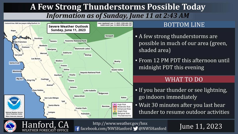
Includes Fresno, Merced, Madera and Mariposa Counties and Yosemite National Park
June 11, 2023 - National Weather Service Hanford Office reports a few strong thunderstorms are possible this afternoon into the evening hours.
Small hail, strong wind gusts, and periods of heavy rainfall are the main hazards expected with these storms.
Area Forecast Discussion
National Weather Service Hanford CA
227 AM PDT Sun Jun 11 2023
.SYNOPSIS...A low pressure system moving across southern
California will provide for showers and thunderstorms today
across the mountains with a chances of precipitation possible
over portions of the San Joaquin Valley and desert areas.
Chances of precipitation will become confined to just the
Sierra Nevada on Monday and will gradually decrease through
the week. High temperatures will cool a few degrees today and
Monday then trend warmer through the end of the week.
&&
.DISCUSSION...Anomalously strong upper low pressure system over
Socal providing our area with unsettled weather this weekend. As
the low moves slowly eastward across Socal it will continue to
pull up some deep moisture and spread it northward into central
CA. Some of the moisture pulled up on Saturday resulted in locally
heavy rainfall over the Sierra Nevada while Mesowest indicated
that many other stations measured a tenth of an inch or less.
Current radar composites are showing a few showers over the
Sierra Nevada and adjacent foothills at this time and with the
moisture surge continuing throughout the day, showers and
thunderstorms will be likely across the mountains with chances of
rain across the Kern County Deserts and the southern and eastern
portions of the San Joaquin Valley. Latest NBM probabilistic
guidance is indicating between a 20 and 40 percent of measurable
rainfall along the east side and south end of the San Joaquin
Valley this afternoon. WRF indicating CAPES of 600 to 1200 J/KG
across much of our area this afternoon and with negative LI/s,
high storm relative helicity and a strong surge of moisture moving
into our area, this afternoon and evening will be active across
our area in terms of thunderstorm coverage, most noticably over
the mountains where some of the storms may contain brief heavy
rainfall, small hail, and strong outflow wind gusts. The strong
southerly steering component will result in these storms being
relatively fast movers which will reduce the potential for
significant flooding although any strong thunderstorm moving over
a burn scar could result in some debris flow later today. The
other impact that this moisture surge will have for our area will
be cooler daytime temperatures as a result of the increased cloud
cover.
The SREF is indicating that the low will slowly shift eastward
into the Desert Southwest tonight and Monday. This will lower the
precipitation potential for our area and keep chances for showers
and thunderstorms confined to the Sierra Nevada and higher
foothills on Monday. Mid/high clouds will continue to wrap around
into central CA which will keep daytime temperatures well below
seasonal normals once again.
A warming and drying trend is expected to begin by Tuesday
although the WRF is showing that some energy will be left behind
by the departing low which will provide for enough instability
and CAPE for chances of afternoon showers and thunderstorms in the
Sierra Nevada.
Medium range ensembles are in fairly good agreement with a slow
warming and drying trend taking place across our area through the
remainder of the week with temperatures nudging upward by a few
degrees each day and reaching climatological normals by late in
the week. Precipitation chances in the Sierra Nevada will decrease
each day as well and will become minimal by the end of the week.
&&
.AVIATION...MVFR conditions possible in and around thunderstorms
with areas of mountain obscuring IFR conditions possible near
showers and thunderstorms in the Sierra NEvada and Tehachapi
Mountains. Otherwise, VFR conditions will prevail across the
central CA interior through at least the next 24 hours.
&&
.AIR QUALITY ISSUES...None.
&&
.CERTAINTY...
The level of certainty for days 1 and 2 is medium.
The level of certainty for days 3 through 7 is medium.
Certainty levels include low...medium...and high. Please visit
www.weather.gov/hnx/certainty.html for additional information
and/or to provide feedback.
&&
.HNX WATCHES/WARNINGS/ADVISORIES...None.
Source: NWS

