


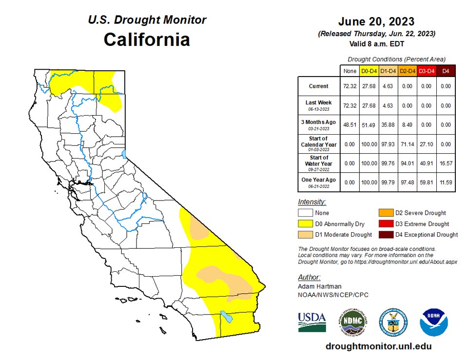
California and National Drought Summary for June 20, 2023
Summary
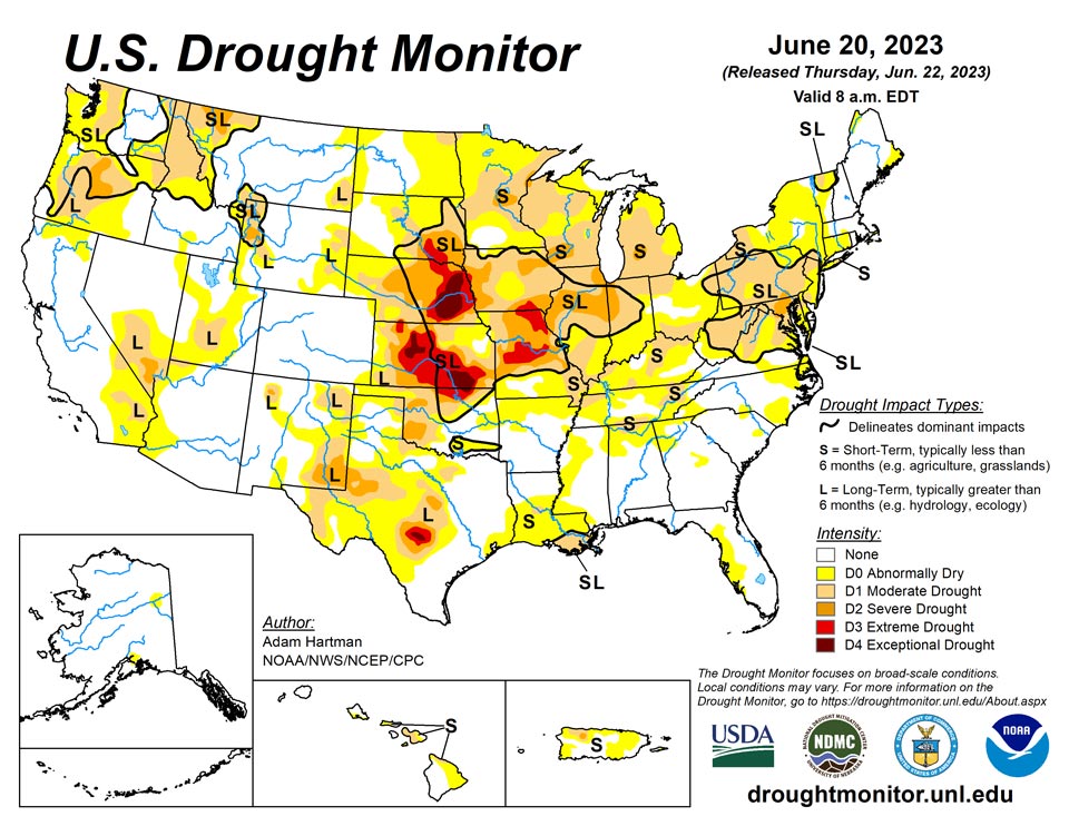
June 22, 2023 - Much of the lower 48 states experienced near to below normal temperatures this week, with the exception of parts of the northern Great Plains, Upper Midwest, southern Texas, and parts of the Lower Mississippi Valley. Large portions of southern Texas experienced excessive heat this week, with daytime high temperatures averaging well above 100°F for several locations. A mean frontal boundary draped across much of the lower 48 states resulted in periods of heavy rainfall across portions of the western Great Plains and Intermountain West, leading to improvements to drought conditions across much of the western half of the lower 48 states. The only exception was in the northern Cascades in Washington, where below-normal precipitation led to worsening drought conditions. Heavy rain also fell across parts of the Southeast, with many locations across the Deep South receiving in excess of 5 inches of rainfall, leading to improvements to abnormally dry and moderate drought conditions from central Mississippi southeastward to Florida. Toward the end of the weekend, a slow-moving storm system traversing eastward across the Middle Mississippi and Ohio Valleys resulted in additional periods of heavy rainfall across portions of the eastern U.S. However, much of the Mississippi and Ohio Valleys and the Northeast experienced a mix of worsening and improving drought conditions based on antecedent dryness and where the heaviest rain fell, respectively. Another round of deterioration was warranted again this week across much of the Midwest and eastern Great Plains, where below average precipitation continued to add to precipitation deficits that go back several months.
Northeast
Much of the Northeast experienced below average daytime high temperatures this week. Several locations in interior portions of the Northeast also received well above normal rainfall totals, leading to improvements in the drought depiction, particularly across northern New England and parts of Upstate New York. Some locations in southeastern Pennsylvania and northern West Virginia also experienced improving drought conditions, associated with a couple of rounds of heavy rainfall, totaling in excess of 2 inches for the week. Unfortunately, short-term dryness leading up to this week warranted further degradation of drought and abnormal dryness (D0) across southern New England and the Mid-Atlantic from the I-95 corridor eastward to the Atlantic Coast.
Southeast
Several rounds of heavy rainfall associated with clusters of thunderstorms warranted improvement to abnormal dryness (D0) and moderate drought (D1) across southern portions of the Deep South from Mississippi to Georgia and into northern Florida. Many areas received more than 5 inches of rainfall as these thunderstorm clusters moved southeastward along a mean frontal boundary. In the days leading up the the end of the week (Tuesday, 6/20), an area of low pressure developed across the Middle Mississippi Valley and began slowly moving eastward, leading to periods of additional rainfall across some of these same areas, in addition to interior and upstate portions of the Carolinas and Virginia. The late-week rainfall helped to stave off further degradation of drought in upstate areas of the Carolinas and Virginia; however, another round of deterioration was warranted across the Coastal Plain of North Carolina and the Virginia Tidewater, as short-term precipitation and soil moisture deficits continue to increase and average stream flows continue to decline.
South
Several rounds of heavy rainfall associated with clusters of thunderstorms traversed portions of the Southern region from Oklahoma to Mississippi, leading to targeted improvements to abnormal dryness (D0) and drought conditions. Additional improvements to the drought depiction are also warranted across portions of the Texas Panhandle, where drought indicators have continued to improve due to well above average (in some cases record) rainfall over the past 60 days. Conversely, targeted degradations are warranted across parts of the Lower Mississippi and Tennessee Valleys, where short-term dryness continues to increase. Excessive heat, especially during the latter portions of the week, helped to exacerbate dryness across portions of southern Louisiana and coastal areas of eastern Texas, where 30-day rainfall deficits continue to increase.
Midwest
Despite predominantly near to below normal temperatures across much of the Midwest, excluding the Upper Midwest and the western Corn Belt, much of the region did not see appreciable rainfall. As a result, short-term (30 to 90 day) dryness continued to worsen, leading to widespread deterioration. The exception to this was across the eastern Corn Belt and into parts of Kentucky, where 7-day rainfall totals helped to improve drought conditions, or at least halt further degradation. Ohio is the greatest beneficiary of the heavy rains this week and saw the most improvement, with several areas receiving more than 2 inches of rainfall.
High Plains
Much of the Northern Plains received below average rainfall this week, adding to short-term precipitation deficits. In conjunction with the below average weekly rainfall, above normal temperatures and high winds (typical for this region) only acted to exacerbate worsening drought conditions by increasing evaporation from soils and vegetation. As a result, widespread degradation of abnormal dryness (D0) and drought was warranted this week across the Dakotas. Degradation was also warranted farther southward, extending across the eastern Great Plains all the way to Kansas, despite more seasonal daytime high temperatures this week. Conversely, across western portions of the High Plains region, another round of improvements is warranted, as yet another week of above normal rainfall (with many areas receiving upwards of 2 inches of rainfall, with locally higher amounts) was observed across many areas, leading to improvements to long-term drought conditions.
West
Another week of above normal rainfall across many areas of the Intermountain West resulted in widespread, yet targeted improvements to long-term drought conditions, assisted by near and below normal average high temperatures for the week. The only area that experienced worsening drought conditions was across parts of the northern Cascades in Washington, where year-to-date precipitation deficits have continued to climb (in excess of 12 inch deficits), and this is following a predominantly below average 2022-2023 winter rainy season. Soil moisture, groundwater levels, and stream flows continue to decline.
Caribbean
Drought conditions worsened across Puerto Rico this week, as short-term precipitation deficits continued to increase and stream flows have rapidly declined in recent weeks. Only northwestern parts of Puerto Rico experienced above normal 7-day rainfall totals, but most of these locations were not depicted in drought or abnormal dryness leading up to this week, so no improvements are warranted.
A tropical wave brought light showers to the U.S. Virgin Islands (USVI) early in this USDM week (June 14-20), while patches of low-level moisture fueled showers later in the week. Otherwise, upper-level and surface ridges of high pressure dominated the region. The high pressure and dry air mass, mixed at times with Saharan dust, generally inhibited showers. Unusually hot temperatures accompanied the dry weather. High temperatures persistently in the 90s with heat indices reaching into the 110s characterized the week over the USVI; an Excessive Heat Watch was in effect for part of the week. Tropical Storm Bret is expected to pass south of the region during the next few days.
Rainfall totals were below normal for the week across the islands, continuing a pattern that has lasted for several months. Weekly totals ranged from 0.21 inch to 0.86 inch on St. Croix, but were mostly less than half an inch. On St. Thomas, totals were a third of an inch or less, while on St. John rainfall totals ranged from 0.02 to 0.21 inch. Month-to-date totals for June were mostly half an inch or less across the islands; the three exceptions were King Airport (0.65 inch), Christiansted 4.1 ESE (1.03 inches), and Christiansted 1.6 E (1.04 inches). The Rohlsen Airport on St. Croix measured 0.28 inch for June so far, or 24% of normal, while the 0.65 inch at King Airport on St. Thomas was 45% of normal and the 0.21 inch at Windswept Beach on St. John was 12% of the long-term average. At Rohlsen AP, December 1, 2022-June 19, 2023 ranked as the driest such period in the 1951-2023 record, not counting years with too much missing data. At King AP, December 1, 2022-June 19, 2023 (the last 7 months) ranked as the fourth driest such period in the 1953-2023 record, not counting years with too much missing data.
Standardized Precipitation Index (SPI) values at the 6-month time scale were at D4 levels on St. Croix and D3 levels on St. Thomas. The SPI showed some level of drought or abnormal dryness on St. Croix for the last 1 to 12 months, and on St. Thomas for the last 1 to 9 months.
The groundwater level at the Grade School 3 well on St. Thomas rose then fell this week, with a declining trend the last 3 weeks. The groundwater levels at the Susannaberg DPW-3 well on St. John and the Adventure 28 well on St. Croix continued to decline this week, with a declining trend at both wells since December of last year. The VHI data, showing vegetative health determined from satellite observations, for the Virgin Islands was not available this week.
At the Rohlsen AP, daily high temperatures were 91 degrees F on each day from June 13 to the 17th, with 89 on the 18th and 90 on the 19th, and daily low temperatures ranged from 77 to 82. At King AP, daily high temperatures ranged from 88 to 91 degrees F and daily lows ranged from 78 to 83. At Rohlsen AP, June 1-19, 2023, ranked as the fourth warmest June 1-19 in the 1951-2023 record for maximum temperatures, third warmest for minimum temperatures, and warmest on record for average temperatures. At King AP, June 1-19, 2023 ranked as the 16th warmest June 1-19 for maximum temperatures in the 1953-2023 record, second warmest for minimum temperatures, and seventh warmest for average temperatures. The excessive heat and breezy conditions increased evapotranspiration, which made the drought conditions worse.
St. Croix continued with exceptional drought (D4-SL) and St. John continued with severe drought (D2-S). St. Thomas continued with severe drought (D2-SL), except the impacts status was changed to SL to reflect dry conditions at longer (more than 6 months) time scales.
Pacific
In Alaska, a small area in the Yukon Flats was degraded to depict abnormal dryness due to a localized increase in the dryness of potential fuel sources for fires brought on by below normal precipitation in recent weeks.
In Hawaii, mounting rainfall deficits continue across the lower leeward slopes of Oahu, leading to abnormal dryness (D0) across southern and western portions of the island. Rainfall deficits also continue to increase across northern parts of the Big Island leading to declining pasture conditions and dropping water levels in stock ponds, consistent with vegetation indices in the region, and resulting in moderate drought (D1) conditions.
Features typical of the western tropical Pacific characterized the weather pattern over the USAPI during this USAPI week. The main features included a near-equatorial trough/monsoon trough in western Micronesia and the Inter-Tropical Convergence Zone (ITCZ) in eastern Micronesia that brought rain to the southern half of the Micronesia region. A typical seasonal trade-wind pattern kept northern portions drier for the week. South of the equator, a low-pressure trough (South Pacific Convergence Zone) brought rain to American Samoa.
Based on data received as of this writing (with 1 to 4 days missing for the week for some locations), the Marshall Islands, most of the Federated States of Micronesia (FSM), and American Samoa were wet this week (above weekly minimums needed to meet most water needs) and for the month so far (except Wotje, which had 4.79 inches for June to date and below the month-to-date minimum of 5.33 inches for so far in June). The Marianas, Palau, and parts of western and northern FSM were dry this week. The Marianas are below the month-to-date monthly minimums, but they were wet last week; Chuuk and Yap were wet last week; and Ulithi was wet 2 weeks ago and wet for the month to date. Weekly rainfall totals ranged from 0.09 inch to 1.40 inches in the Marianas, 0.42 inch at North Fanif to 10.25 inches at Kapingamarangi in the FSM, and 2.11 to 3.88 inches in the Marshalls. Palau IAP reported 1.23 inches and Pago Pago 3.42 inches. The weekly minimum rainfall needed to meet most water needs is 1 inch for the Marianas and American Samoa, and 2 inches for the rest of the U.S.-Affiliated Pacific Islands (USAPI).
With wet conditions at many locations this week, and wet conditions during previous weeks at most locations, there was no drought or abnormal dryness across the USAPI at this time.
Looking Ahead
According to the Weather Prediction Center (WPC), over the next 6 days (June 22 - 27) above normal temperatures are forecast to dissipate and become more seasonal across the Great Lakes and Middle and Upper Mississippi Valley, and become confined to the south-central U.S. Parts of the Southern Plains could see record heat this week, as temperatures are likely to soar well above 100°F for many locations, with the potential for some locations to exceed 110°F. Much of the remainder of the lower 48 states is likely to experience seasonal to below normal temperatures. WPC predicts above normal precipitation across portions of the Central and Northern Plains and Upper Midwest, with the potential for several areas to receive in excess of 3 inches of rainfall. Above normal rainfall is also expected across much of the Eastern U.S., associated with a lingering storm system helping to usher in moisture from the western Atlantic.
During the next 6 to 10 days (June 27 - July 1), the Climate Prediction Center (CPC) favors near to below normal temperatures across much of California and the central Great Basin. Near to below normal temperatures are also predicted across much of the northern tier states from the Northern Plains to the Great Lakes, and southeastward into the Mid-Atlantic. Above normal temperatures are favored in the Pacific Northwest and New England. Above normal temperatures are strongly favored across the south-central U.S., with the potential for record heat across portions of the Southern Plains and Lower Mississippi Valley. Near and above normal precipitation is favored across much of the lower 48 states. However, below normal precipitation is more likely across the Four Corners region, extending eastward into the Southern Plains and Lower Mississippi Valley.
Author(s):
Adam Hartman, NOAA/NWS/NCEP/CPC
Richard Heim, NOAA/NCEI
Dryness Categories
D0 Abnormally Dry—used for areas showing dryness but not yet in drought, or for areas recovering from drought.
Drought Intensity Categories
D1 Moderate Drought
D2 Severe Drought
D3 Extreme Drought
D4 Exceptional Drought
Drought or Dryness Types
S Short-term, typically less than 6 months (agriculture, grasslands)
L Long-term, typically more than 6 months (hydrology, ecology)
SL Area contains both short- and long-term impacts
Source: National Drought Mitigation Center
