


Includes Mariposa, Oakhurst and Shaver Lake
July 21, 2023 - National Weather Service Hanford officials report afternoon highs today will be hotter.
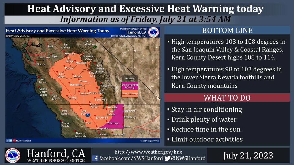
A Heat Advisory is in effect today for much of the region up to around 5,000 feet, including the San Joaquin Valley, Coastal Ranges, lower Sierra Nevada foothills, and the Kern County mountains where highs around 98 to 108 degrees are forecast.
Expect even hotter temperatures in the Mojave Desert portion of Kern County where highs of 108 to 114 degrees are projected. Thus, an Excessive Heat Warning is in effect for the desert areas both today and Saturday. Take caution in these areas.
Stay in air conditioning if possible, limit outdoor activities, reduce time in the sun, and drink plenty of water.
The hottest times of the day are from late morning until early evening.
Area Forecast Discussion
National Weather Service Hanford CA
141 AM PDT Fri Jul 21 2023
.SYNOPSIS...
Triple digit heat is expected to continue across most of the San
Joaquin Valley and Kern County desert areas through the next
several days. Very hot temperatures are in store through this
weekend. Mainly dry conditions will prevail through next week.
&&
.DISCUSSION...
Temperatures were about as warm yesterday than on the previous
day, although some areas observed slightly lower highs. It was
mainly seasonably warm for this time of year; however, well above
average temperatures return this afternoon with even hotter
afternoon highs on Saturday. The probability for a 105 degree or
hotter reading remains at 55 to 90 percent in the San Joaquin
Valley with a similar probability range for highs at or above 110
degrees in the Kern County desert areas for both today and
Saturday. The upper-level ridge of high pressure will be moving
from the Desert Southwest and strengthening over our forecast area
over the next couple of days.
We have also extended the Excessive Heat Warning for our Kern
County desert zones into Sunday, as afternoon highs will only be
slightly lower. As for morning lows, they will also be quite warm.
There is at about a 30 to 55 percent chance that the larger
population centers in the Central Valley (Bakersfield and Fresno)
will fail to fall below 80 degrees, while the populated areas in the
Kern County desert (such as Ridgecrest and Mojave) have a similar
to probability to remain in the upper 70's on Sunday morning.
We are still looking at the potential for increased mid-level
moisture from the southeast during the weekend. So, we may be
shifting to a monsoonal pattern, at least in the form of increased
humidity and mid-level clouds. Latest ensemble and deterministic
guidance hints that the upper-level ridge of high pressure will
retrograde over the weekend which would allow the flow aloft to
become more southeasterly. However, it appears the deeper
monsoonal moisture will remain well to our east, so we will keep
the forecast dry for now.
For early next week, the pattern transitions to a more
southwesterly flow aloft, as an upper-level trough approaches the
Pacific Northwest. Latest high resolution guidance suggests this
change by Monday. While much of our area will remain warm, it
won't be so hot. However, triple digit readings continue in our
Central Valley and desert zones until at least Tuesday.
Beginning midweek, probabilistic data do show only a moderate
chance (generally 20 to 40 percent) of 100 degree readings in the
Central Valley. Some 105 degree readings have a moderate chance
(up to 40 percent) of occurrence from Wednesday through next
Friday for the Kern County desert areas, though mainly towards the
Indian Wells Valley. So, the forecast data suggest that we cannot
quite get rid of the triple digits in our warmest locations just
yet. It will be near the end of July, which is our warmest time of
year, climatologically speaking. A reading at or just above the
century mark is actually considered seasonably warm for much of
our CWA.
&&
.AVIATION...
Local MVFR conditions due to haze and smoke in the San Joaquin
Valley along with isolated mountain obscuring IFR possible in the
Sierra Nevada through 03Z Saturday. Otherwise, VFR conditions
will prevail throughout the Central CA Interior for at least the
next 24 hours.
&&
.AIR QUALITY ISSUES...
None.
&&
.CERTAINTY...
The level of certainty for days 1 and 2 is high.
The level of certainty for days 3 through 7 is medium.
Certainty levels include low...medium...and high. Please visit
www.weather.gov/hnx/certainty.html for additional information
and/or to provide feedback.
&&
.HNX WATCHES/WARNINGS/ADVISORIES...
Excessive Heat Warning from 11 AM this morning to 11 PM PDT
Sunday for CAZ337>339.
Heat Advisory from 11 AM this morning to 11 PM PDT this evening
for CAZ300>322-324-325-332>336.
Heat Advisory from 11 PM Saturday to 11 PM PDT Sunday for
CAZ300>317-319-321-322-332>336.
Excessive Heat Warning from 11 PM this evening to 11 PM PDT
Saturday for CAZ300>322-324-325-332>336.
Source: NWS
