


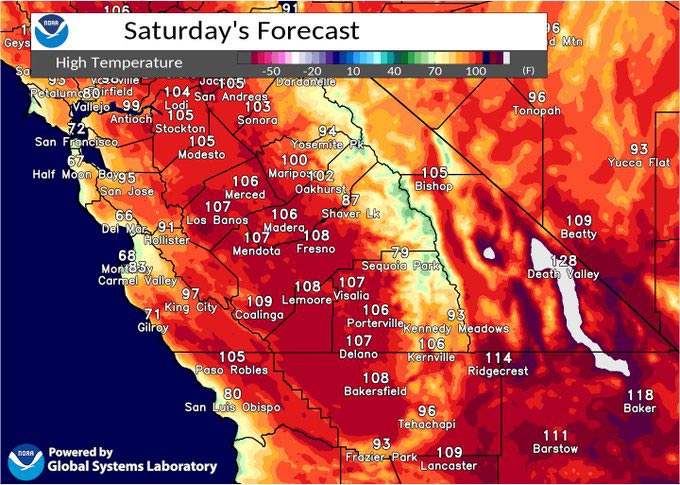
July 22, 2023 - National Weather Service Hanford Office officials report dangerous heat in most of Central California today will result in a major risk for heat-related illnesses for much of the population if precautions are not taken.
Drink plenty of fluids, stay out of the sun, and remain in an air-conditioned room.
Area Forecast Discussion
National Weather Service Hanford CA
337 AM PDT Sat Jul 22 2023
.SYNOPSIS...
Dangerous heat is expected in most of Central California this
weekend, with a major risk for heat-related illnesses Saturday. A
downward temperature trend is then anticipated Monday through the
middle of next week, with high temperatures down to around normal
by the end of the week. A few showers or thunderstorms cannot be
ruled out Sunday, otherwise dry conditions will prevail.
&&
.DISCUSSION...
A strong ridge of high pressure centered over the southwest states
created dangerous heat conditions over central California Friday,
with afternoon highs around 105 degrees at many San Joaquin
Valley locations. High temperatures this afternoon will trend
upward a few degrees from yesterday under the influence of the
high pressure ridge, resulting in another day of dangerous heat.
An Excessive Heat Warning is therefore in effect for most of
central California below around 5000 ft elevation. Here are
probabilities of maximum temperatures of 106 degrees or higher for
select locations in the San Joaquin Valley this afternoon:
Fresno - 86%
Bakersfield - 81%
Delano - 71%
Lemoore - 76%
Porterville - 66%
Visalia - 61%
Hanford - 61%
Merced - 56%
Madera - 46%
Sunday brings a degree or so of moderation in temperatures as the
high pressure ridge recenters near the Four Corners region.
Moderate to major risk for heat related illnesses will remain over
much of our area, prompting a Heat Advisory for the San Joaquin
Valley, Lower Foothills, Coastal Range and Kern County Mountains
Sunday, with the Excessive Heat Warning continuing for the Kern
County Desert zones. The south to southeasterly flow around the
center of the ridge will draw some moisture into our area Sunday,
and there is some indication from the high resolution convection-
allowing models that this moisture could lead to a few showers and
thunderstorms.
As the center of the ridge slides a bit southeastward, a downward
temperature trend will continue through the middle of the week.
By the end of next week, blended model guidance shows afternoon
highs right around normal values for late July. Probabilities of
high temperatures in the San Joaquin Valley remaining below 100
degrees on Friday range from around 75% to near 100%.
&&
.AVIATION...
VFR conditions will prevail across Central California for at
least the next 24 hours.
&&
.AIR QUALITY ISSUES...
None.
&&
.CERTAINTY...
The level of certainty for days 1 and 2 is high.
The level of certainty for days 3 through 7 is high.
Certainty levels include low...medium...and high. Please visit
www.weather.gov/hnx/certainty.html for additional information
and/or to provide feedback.
&&
.HNX WATCHES/WARNINGS/ADVISORIES...
Excessive Heat Warning until 11 PM PDT Sunday for CAZ337>339.
Excessive Heat Warning until 11 PM PDT this evening for
CAZ300>322-324-325-332>336.
Heat Advisory from 11 PM this evening to 11 PM PDT Sunday for
CAZ300>317-319-321-322-332>336.
Source: NWS
