


California and National Drought Summary for August 1, 2023
Summary
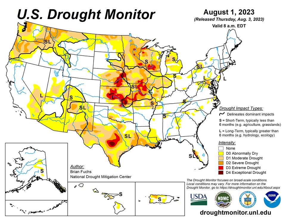
August 3, 2023 - Dry conditions dominated the West and southern Plains, coupled with above-normal temperatures. Precipitation was most widespread throughout much of the upper Midwest and central Plains and into the Northeast. Almost the entire country had near- to above-normal temperatures this last week, with the greatest departures over the Southwest and central Plains where temperatures were at least 4-7 degrees above normal. Cooler-than-normal temperatures were recorded in the Pacific Northwest with departures of 3-6 degrees below normal. At the end of the current U.S. Drought Monitor period, significant rains developed over portions of the Midwest and central Plains, and they will be accounted for in the next analysis.
Northeast
Temperatures for the week were generally near normal to 2-4 degrees above normal with the greatest departures over northern Virginia. Precipitation was scattered but most of the region did record some precipitation. The greatest departures from normal were over western Pennsylvania and New York as well as into New England. Dry conditions were observed over northern Virginia and into western Maryland. Abnormally dry conditions were improved in New York and Connecticut as well as northern and southern New Jersey. Moderate drought was improved over western New York and southern New Jersey. Severe drought was expanded over central Maryland and moderate drought and abnormally dry conditions were improved over western and central Pennsylvania. Some slight improvements to moderate drought and abnormally dry conditions through northern Virginia and southern Maryland were also incorporated this week.
Southeast
It was a dry week over the region with only pockets of scattered rain, mainly over the coastal regions of east Florida, and the Carolinas. Temperatures were cooler than normal over east Georgia and southern South Carolina, with departures of 1-2 degrees below normal. Most of the rest of the region was 1-3 degrees above normal for the week. Abnormally dry conditions were expanded in Alabama, Georgia, South Carolina and North Carolina this week. The drought intensities were adjusted slightly along the west coast of Florida.
Midwest
Warmer-than-normal temperatures dominated the region this week with departures of 6-8 degrees above normal over portions of southern Illinois into northeastern Missouri. The upper Midwest recorded the greatest rains, with 200-300% of normal rain received over Wisconsin, Michigan and areas of eastern Minnesota. Portions of northern Illinois and northern Indiana into northern Ohio also received above-normal precipitation. Significant rains developed over Iowa and Missouri after the period for analysis this week, and they will be considered for next week’s map. Most of the changes in the region were improvements this week, with some degradation limited to the western portions of the region. Abnormally dry and moderate drought were improved over Ohio, Indiana, western Kentucky, southern Illinois, lower Michigan, southern Wisconsin and northern Illinois. Improvements were also made in western Minnesota and central Missouri due to recent convective rains bringing above-normal precipitation. As the spotty precipitation continued, some areas of degradation were also made, with severe and extreme drought expanding in southern and northern Minnesota, eastern Iowa and portions of northern and southeast Missouri.
High Plains
Precipitation was mixed in the region for the week. Areas of northwest North Dakota and throughout much of Nebraska recorded above-normal precipitation while most of Kansas, eastern South Dakota and eastern Colorado were below normal for the week. Temperatures were above normal for the week along with some areas of high dew point temperatures too. Departures were generally 2-4 degrees above normal for the week, with areas of central Kansas, western North Dakota and eastern Nebraska 6-8 degrees above normal. The recent trend of wetter conditions over Nebraska allowed for improvements to be made to the drought depiction this week. Extreme and severe drought were improved over north central Nebraska and southeast Nebraska. Drought expanded and intensified over most of northern North Dakota where moderate drought conditions now cover much of the northern tier of the state. Abnormally dry conditions expanded over northern South Dakota.
South
Temperatures were near normal to slightly above over most of the region, with the greatest departures from normal in west Texas and the Texas and Oklahoma panhandles, where departures were 4-6 degrees above normal. It was an incredibly dry week over the region with only a few pockets of showers over northern Arkansas and coastal areas of Texas. Most of the region recorded zero precipitation for the week. Severe drought expanded over east Texas and southern Louisiana and a new area of severe drought was introduced over far west Texas. Moderate drought expanded over southwest Oklahoma and northern Texas.
West
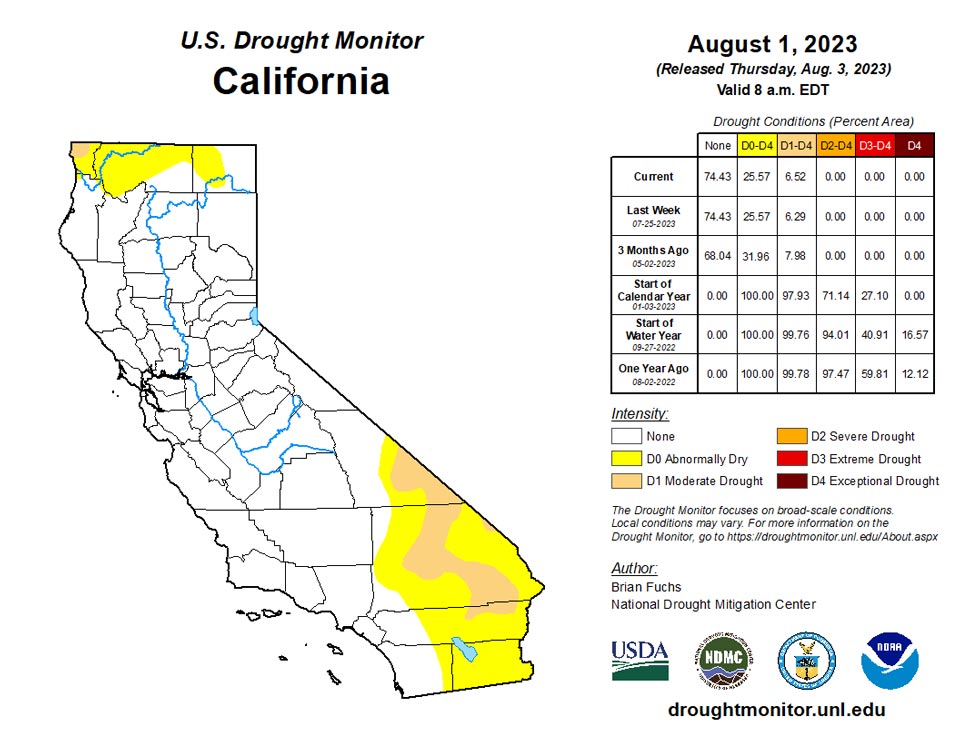
Temperatures were mixed in the region with areas of the Pacific Northwest recording below-normal temperatures with departures of 3-6 degrees below normal. Most of the rest of the region was near normal to above normal, with the greatest departures over the Southwest with temperatures generally 3-6 degrees above normal. The monsoon moisture became more widespread throughout the Southwest, with areas of the Four Corners states all seeing scattered rain events. The central valley of California as well as the Pacific Northwest also recorded above-normal precipitation. Moderate drought was introduced in southeast Utah into southwest Colorado and expanded in southern New Mexico. Abnormally dry conditions expanded over northern New Mexico and southwest Utah and southwest Colorado. Montana had an expansion of severe and moderate drought and a large expansion of abnormally dry conditions. In the Pacific Northwest, severe drought was expanded in Washington and Oregon, moderate drought expanded in northeast and southwest Oregon and abnormally dry conditions expanded into more of central Washington.
Caribbean
There were no changes in Puerto Rico this week.
A couple tropical waves brought showers to the U.S. Virgin Islands (USVI) during this USDM week. Rainfall totals for the week ranged from a third of an inch to a little over an inch across St. Croix, half an inch to two-thirds of an inch on St. Thomas, and around an inch on St. John. But the region has been in a dry spell that dates back to December 2022. Rohlsen AP on St. Croix had the second driest December 1-July 31 period in a 64-year record, while King AP on St. Thomas ranked third driest for the December-July period in a 59-year record. Unusually hot temperatures this summer have accompanied the dryness, with Rohlsen AP having the fifth hottest June-July and King AP having the sixth hottest June-July. The excessive heat enhances evapotranspiration that, combined with low rainfall, creates stress on vegetation, which is showing up on satellite observations of the region. Groundwater further declined during July, continuing an overall trend dating back to the beginning of the year or longer. Short- and long-term extreme drought (D3-SL) continued on St. Croix and St. Thomas, but the rain this week was enough to improve conditions to moderate drought (D1-SL) on St. John.
Pacific
In Alaska, recent dryness allowed for the expansion of abnormally dry conditions and the introduction of moderate drought.
There were no changes in Hawaii this week.
A monsoon trough and a tropical system (which later became Typhoon Khanun west of the region) brought abundant rain to western portions of the Micronesia region during this USDM week. Weekly rainfall totals in the Marianas ranged from 1.70 inches at the Saipan IAP to 3.23 inches at Guam. The rain was enough to end the abnormal dryness on Saipan. Over 4 inches of rain was recorded in the Republic of Palau, and 3 to over 10 inches occurred in western Yap State. These weekly totals are above the 2-inch weekly minimum needed to meet most water needs here, and they raised monthly rainfall totals above the 8-inch monthly minimums. It was also a wet week (more than one inch) and month (more than 4 inches) in American Samoa at Tutuila. There is no drought or abnormal dryness in the Marianas, Palau, or American Samoa.
Elsewhere in the Federated States of Micronesia (FSM), it was a dry week (less than 2 inches) at Fananu (0.58 inch), Lukunor (1.50 inches), and Kapingamarangi (1.36 inches). The previous week and this month (July) have been wet at Lukunor and Kapingamarangi. However, at Fananu, this week was dry (0.58 inch), the last five weeks have been dry, and both June (7.28 inches) and July (5.00 inches) were dry, so abnormal dryness (D0-S) was introduced at Fananu. Aside from Fananu, there was no drought or abnormal dryness in the FSM.
In the Marshall Islands, Ailinglaplap, Majuro, and Mili had a wet week, but Jaluit, Kwajalein, and Wotje reported less than the weekly minimum rainfall amount of 2 inches. Abnormal dryness continued at Kwajalein and Wotje, both of which had a dry week and dry month. Jaluit had a dry week and month, but the previous week was wet. Conditions at Utirik could not be assessed due to lack of data. Aside from Kwajalein and Wotje, the Marshall Islands are free of drought or abnormal dryness.
Looking Ahead
Over the next 5-7 days, precipitation chances are anticipated to be best over the northern Rocky Mountains, central Plains and into the Southeast where forecasted rain totals could approach 3-4 inches in places. Dry conditions will dominate the southern Plains, Southwest and along the West Coast. Temperatures will be 12-15 degrees below normal over the central Plains to the northern Rocky Mountains and 8-12 degrees above normal in the southern Plains and Southwest.
The 6–10 day outlooks show a high probability of cooler-than-normal temperatures over the Northern Rocky Mountains, central and northern Plains and into the Midwest. The best chances of above-normal temperatures are over the Southwest, southern Plains and into the Southeast. Much of the country is showing an above-normal chance of above-normal precipitation, with only the Southwest and far southern Plains having high probabilities of below-normal precipitation.
Author(s):
Brian Fuchs, National Drought Mitigation Center
Brad Rippey, U.S. Department of Agriculture
Dryness Categories
D0 Abnormally Dry—used for areas showing dryness but not yet in drought, or for areas recovering from drought.
Drought Intensity Categories
D1 Moderate Drought
D2 Severe Drought
D3 Extreme Drought
D4 Exceptional Drought
Drought or Dryness Types
S Short-term, typically less than 6 months (agriculture, grasslands)
L Long-term, typically more than 6 months (hydrology, ecology)
SL Area contains both short- and long-term impacts
Source: National Drought Mitigation Center
