


California and National Drought Summary for August 8, 2023
Summary
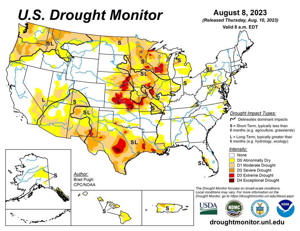
August 10, 2023 - A strong area of mid-level high pressure, anchored over the southern tier of the country, continued to promote above-normal temperatures and mostly dry weather across the Rio Grande Valley, Texas, and the lower Mississippi Valley. Weekly temperatures (August 2 to 8) averaged more than 6 degrees F above normal across portions of Louisiana, Texas, and southern New Mexico. The persistence of this pattern led to rapidly developing and intensifying drought across Texas and the lower Mississippi Valley. The Monsoon remains suppressed with increasing short-term drought across Arizona, New Mexico and southwest Colorado. Frequent rounds of heavy rainfall occurred from the central Great Plains southeastward to the middle Mississippi Valley. During the first week of August, parts of Missouri received 5 to 10 inches (locally more) of rainfall. The wet start to August resulted in improving drought across parts of the Corn Belt. Farther to the north, drought continues to intensify across Wisconsin. On August 7, a severe weather outbreak with heavy rainfall affected the East. Short-term drought expanded this past week across parts of the Hawaiian Islands.
Northeast
A 1-category improvement was made in the DC/Baltimore areas after more than 1.5 inches of rainfall. However, long-term indicators continue to support abnormal dryness (D0) and moderate drought (D1) along and to the west of I-95. Heavy rainfall (locally more than 3 inches) led to the removal of D0 in central New York, while D0 and D1 continues on Long Island. Recent rainfall of more than 1.5 inches led to a reduction of D0 across northern West Virginia. Based on 30 to 90-day SPI, D0 was added to Nantucket and Martha’s Vineyard in southeastern Massachusetts.
Southeast
Se logró una mejora de categoría 1 en las áreas de DC/Baltimore después de más de 1.5 pulgadas de lluvia. Sin embargo, los indicadores a largo plazo continúan apoyando la sequía anormal (D0) y la sequía moderada (D1) a lo largo y al oeste de la I-95. Las fuertes lluvias (localmente más de 3 pulgadas) provocaron la eliminación de D0 en el centro de Nueva York, mientras que D0 y D1 continúan en Long Island. Lluvias recientes de más de 1,5 pulgadas llevaron a una reducción de D0 en el norte de Virginia Occidental. Con base en SPI de 30 a 90 días, se agregó D0 a Nantucket y Martha's Vineyard en el sureste de Massachusetts.
South
Increasing 30 to 60-day precipitation deficits coupled with excessive heat and high evapotranspiration rates support a widespread 1-category degradation across Texas, Louisiana, and southwest Mississippi. 30 to 60-day SPI/SPEI, NDMC’s short-term blend, and soil moisture were leaned on for these degradations. During the past two months, temperatures have averaged 2 to 6 degrees F above normal across parts of Texas and Louisiana. Heavy rainfall (more than 2 inches) resulted in a 1-category improvement to northern and eastern Oklahoma along with parts of Tennessee.
Midwest
Heavy rainfall (2 to 8 inches, locally more) during the first week of August prompted widespread improvements to Missouri, southern Iowa, Illinois, and Indiana. A few 2-category improvements were justified across Missouri and Illinois where more than 6 inches of rainfall occurred and there was support from the short to long-term indicators. Despite widespread, heavy rainfall (more than 1.5) across western Iowa this past week, improvements were limited given the longer-term drought indicators and a reassessment can be made in subsequent weeks. Severe (D2) to extreme (D3) drought was expanded across Wisconsin based on continued dryness dating back to the late spring. Exceptional (D4) drought was added to northern portions of Douglas and Ashland counties in northern Wisconsin. Superior has received 4.71 inches of rain since May 1 which is the driest on record.
High Plains
Above normal precipitation since the beginning of July and a lack of support from the long-term indicators led to a 1-category improvement to west-central Nebraska and bordering areas of Kansas. Recent beneficial precipitation also resulted in improving conditions across parts of the Dakotas and Wyoming. Short-term drought was expanded across northeast North Dakota which remained to the north of the storm track. The lack of Monsoon rainfall this summer resulted in the addition of short-term drought to southwestern Colorado.
West
The suppressed Monsoon and associated above-normal temperatures resulted in a 1-category degradation across Arizona and New Mexico. Recent rainfall supported a decrease in abnormal dryness (D0) in southeast Montana, while a 1-category degradation was made to parts of northern Montana based on worsening short-term indicators. Following 1-category degradations to parts of Oregon and Washington the previous week, no changes were made.
Caribbean
Since the heaviest precipitation generally fell across drought-free areas of Puerto Rico, no changes were made this week.
Status quo was maintained on St. Thomas, St. John and St. Croix this week. On St. Thomas, rainfall totals ranged from 0.68 to 1.09 inches, while groundwater levels improved a bit. However, given the recent hot weather and the lack of more significant rainfall, conditions there have not yet moved out of extreme short- and long-term drought. Rainfall totals on St. Croix varied widely this week, with CoCoRaHs observations ranging from 0.38 inches on the low end to 2.24 inches on the high end. Groundwater levels did not respond much and remained low, and short- and long-term extreme drought was maintained this week. Groundwater level data was not available on St. John this week, where rainfall observations totaled 0.95 and 0.97 inches. Short- and long-term moderate drought continued there.
Pacific
Abnormal dryness (D0) was expanded across eastern Mainland Alaska and southeastern Alaska due to recent dryness and warmth.
Abnormal dryness (D0) was expanded on the west side of Kauai, based on low July rainfall totals. Drier-than-normal conditions and an increase in brush fires led to a 1-category degradation across the lower slopes of western Oahu. Worsening short-term indicators supported a 1-category degradation across much of Maui. Except for rainfall associated with Tropical Storm Calvin during July, dryness has increased across much of the Big Island with a corresponding expansion of D0 and an addition of moderate drought (D1) warranted.
Rainfall at the Palau airport this week totaled 4.73 inches, while a cooperative observing site reported 11 inches and Palau remained free of drought or abnormal dryness.
Relatively dry recent weather continued this week in American Samoa, where only 0.01 inches of rain was reported at Siufaga Ridge and Toa Ridge, while Pago Pago recorded 0.42 inches. Dryness has not yet risen to the threshold of abnormally dry conditions, though the drier weather will continue to be monitored in the coming weeks.
Conditions remained free of drought or abnormal dryness in the Mariana Islands this week. Rainfall at Saipan Airport totaled 1.26 inches, exceeding their 1-inch weekly threshold. National Weather Service observing sites on Rota and Guam received 1.93 and 3.08 inches of rain, respectively. Rainfall reported by CoCoRaHs observers on Guam ranged from 0.55 inches on the low end to 3.15 inches on the high end for this week.
Drought-free conditions continued on Yap, Ulithi and Woleai this week. Yap reported at least 7.98 inches of rain for the week, while Ulithi and Woleai came in with at least 5.66 and 2.4 inches, respectively. The depiction for Fananu was changed from short-term abnormal dryness to a “no data” depiction, as five days were missing from this week’s reports. The two days accounted for on the island totaled 0.21 inches of rainfall, with five consecutive weeks before that failing to reach a 2-inch weekly rainfall threshold. Chuuk, Lukunor and Nukuoro all remained free of drought or abnormal dryness, as rainfall totaled 6.75, and at least 5.16 and 4.78 inches of rain, respectively. Kapingamarangi recorded 1.4 inches of rain this week, following 1.36 from last week. While drier for the last couple of weeks, this has not risen to the level of abnormal dryness, especially considering record wetness there in July. Pohnpei received at least 11.24 inches of rain this week, and they remained free of drought or abnormal dryness. Only 0.42 inches of rain were recorded at Pingelap this week, continuing a general trend toward drier weather over the last month or so. However, given that 2.83 inches of rain fell there last week, they remained free of drought or abnormal dryness. Kosrae recorded 2.95 inches of rain this week, and they remained free of drought or abnormal dryness.
Only 0.51 inches of rain were reported on Kwajalein this week, though three days were missing from the total; given this, short-term abnormal dryness was maintained there this week. Ailinglapalap remained free of drought or abnormal dryness this week, as rainfall totaled 3.55 inches. Jaluit also remained free of drought or abnormal dryness, though a weekly rainfall total of 1.1 inches marked their second week in a row with less than 2 inches of rainfall. No depiction was made for Utirik this week, as no data was available from there. Short-term abnormal dryness continued on Wotje, though with 3.13 inches of rain this week, conditions have likely begun to improve there. Majuro reported 1.11 inches of rain this week, though with a wetter last couple of weeks, Majuro remained free of drought or abnormal dryness. Mili remained free of drought or abnormal dryness this week, as they totaled 6.77 inches of rain.
Looking Ahead
According to the Weather Prediction Center (WPC), during the next five days (August 10 - 14, 2023), moderate to heavy precipitation (0.5 to 2 inches, locally more) is forecast for the Midwest, Ohio and Tennessee Valleys, and Northeast. Farther to the south, little to no precipitation and above-normal temperatures are forecast to persist across the lower Mississippi Valley and Texas. Scattered thunderstorms may result in local amounts in excess of 0.5 inches for the Four Corners region. A warming trend is expected for the Pacific Northwest and intermountain West during mid-August.
The Climate Prediction Center’s 6-10 day outlook (valid August 15 - 19, 2023) depicts large probabilities (more than 60 percent) for above-normal temperatures throughout much of the West, southern Great Plains, and Gulf Coast. Probabilities for above-normal temperatures decrease farther to the north with a slight lean towards below-normal temperatures across the northern Great Plains. Above-normal precipitation is slightly favored across the northern Rockies, northern Great Plains, upper Mississippi Valley, and New England, while below-normal precipitation is more likely across the southern Great Plains and lower Mississippi Valley
Author(s):
Brad Pugh, NOAA/CPC
Curtis Riganti, National Drought Mitigation Center
Dryness Categories
D0 Abnormally Dry—used for areas showing dryness but not yet in drought, or for areas recovering from drought.
Drought Intensity Categories
D1 Moderate Drought
D2 Severe Drought
D3 Extreme Drought
D4 Exceptional Drought
Drought or Dryness Types
S Short-term, typically less than 6 months (agriculture, grasslands)
L Long-term, typically more than 6 months (hydrology, ecology)
SL Area contains both short- and long-term impacts
Source: National Drought Mitigation Center
