


Includes Fresno, Madera and Mariposa Counties including Oakhurst and Yosemite
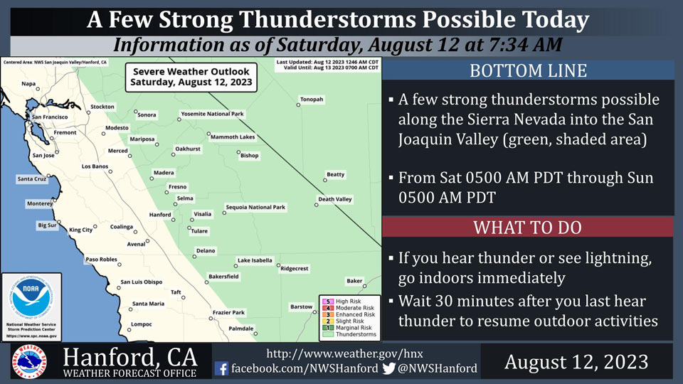
August 12, 2023 - National Weather Service Hanford Office officials report a 30% chance of thunderstorms in the Central Sierra Nevada this afternoon, with a 10% chance of storms moving into the valley during the late afternoon.
Area Forecast Discussion
National Weather Service Hanford CA
1247 AM PDT Sat Aug 12 2023
.SYNOPSIS...An influx of moisture and instability from the
remnants of Tropical Storm Eugene will provide for scattered
showers and thunderstorms over the Sierra Nevada through Saturday.
A warming trend will take place across the area with temperatures
rising to near normal Saturday and above normal Sunday through at
least the middle of next week.
&&
.DISCUSSION...
Satellite imagery this morning shows our upper low with remnants
of Tropical Storm Eugene spinning just offshore. Precipitation
this morning is limited and outside of our CWA. Moisture with this
system will continue to impact the region this afternoon,
especially for our Sierra Nevada zones. Showers and thunderstorms
are expected to increase through the afternoon hours today with
some lingering into the late evening and early hours of Sunday.
As we progress through the weekend, models indicate an upper level
ridge retrograding westward and setting up through the southwest
US which will bring much warmer temperatures back to the region.
By Monday, NBM probabilities to reach at least 100F sit well above
90% with much of the central valley sitting near 98%.
Probabilities remain near 95-98% through Thursday afternoon with
high temperatures expected to peak on Thursday. Heat Risk at this
time looks to reach Moderate to Major or level 2 and 3 out of 4
respectively during the start of next week. Be on the lookout for
potential heat products being issued in the next 12 to 24 hours.
There is an end in sight for this heat again as an upper low
starts to progress toward the coastline which will help to weaken
this ridge and bring temperatures back down to near normal again
by the end of next week.
&&
.AVIATION...Areas of MVFR and local mountain obscuring IFR in
showers and thunderstorms over the Sierra Nevada are possible
through 06Z Sat and again after 18Z Sat. Otherwise, VFR
conditions will prevail across the Central CA interior for at
least the next 24 hours.
&&
.AIR QUALITY ISSUES...
ISSUED: 08/11/2023 13:40
EXPIRES: 08/12/2023 23:59
None.
&&
.CERTAINTY...
The level of certainty for days 1 and 2 is high.
The level of certainty for days 3 through 7 is medium.
Certainty levels include low...medium...and high. Please visit
www.weather.gov/hnx/certainty.html for additional information
and/or to provide feedback.
&&
.HNX WATCHES/WARNINGS/ADVISORIES...
None.
&&
Source: NWS
