


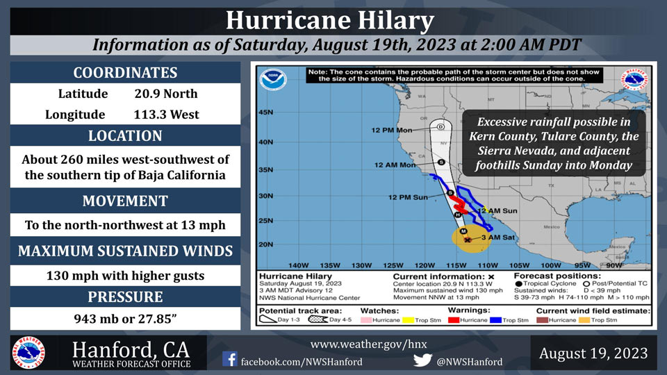
August 19, 2023 - National Weather Service officials report at 2:00 A.M. PDT Saturday, August 19th, 2023, Hilary remains a category 4 hurricane on the Saffir-Simpson Hurricane Wind Scale.
Hurricane Hilary will weaken this weekend as it moves northward over cooler waters.
Hilary is expected to be a tropical storm by midday Sunday, before it reaches Southern California.
There is a moderate risk (40-70%) of excessive rainfall in the Kern County mountains and desert Sunday and Sunday night.
There is a slight risk (15-40%) of excessive rainfall in the remainder of Kern County, Tulare County, the Sierra Nevada, and adjacent foothills Sunday and Sunday night.
Area Forecast Discussion
National Weather Service Hanford CA
118 AM PDT Sat Aug 19 2023
.SYNOPSIS...
Warm temperatures continue today across the forecast area. An
impressive field of moisture associated with Tropical Cyclone
Hilary will arrive by this afternoon which coincides with the
onset of rain. Rainfall is forecast to be heaviest Sunday into
early Monday that will lead to a significant risk of flooding
across the southern portion of the forecast area. Drier and
warmer conditions are forecast later next week.
&&
.DISCUSSION...
Hurricane Hilary remains the main concern for the next couple of
days, and NHC forecasts the center of the storm to weaken to a
tropical storm as it makes landfall in Northern Baja near the
international border by Sunday evening. The storm will move
northward over the deserts of California late Sunday night and
into Central Nevada by Monday. Meanwhile, the arrival of mid-
level tropical moisture associated with this system will bring
rain chances starting this afternoon in much of the mountains of
Tulare and Kern Counties, as well as the Kern County desert.
Additional moisture will flow into this region by the evening into
Sunday as the storm moves to Northern Baja near the border with
Southern CA, and hourly rainfall rates will continue to increase.
East to southeast winds will also increase towards the Kern
County mountains, including through the Grapevine in Kern County,
into the desert by this evening and continue into Sunday. Any
easterly winds would be orographic in nature and could enhance
rainfall amounts on east-facing (desert-facing) slopes in the
mountains of eastern Kern County. In addition, the Flood Watch
looks good for these areas, as well as for the southern Sierra
Nevada.
The probability for at least an inch of rain is highest on
Sunday. Bakersfield has a 53 percent chance of an inch of rain or
more with a 31 percent chance of at least two inches of rain, and
the Kern County desert areas have around a 85 percent chance of
an inch of rain and about a 60 percent chance of two inches of
rain, including from China Lake NAWS to Edwards AFB. Rain chances
will last throughout the day on Sunday until early Monday morning,
but the heaviest rain will occur mainly on Sunday evening until
early Monday morning. Locations in Kern County will receive the
most precipitation, but anywhere else in our forecast area can
expect some rain. The chance for a half inch of rain for areas
north of Kern County range from around 15 to 50 percent, with the
lesser probabilities towards the north, including Merced. We will
continue to monitor for the potential for gusty winds
accompanying this storm into Sunday.
Lingering showers will continue in much of Central California on
Monday along with a slight chance of thunderstorms. By Tuesday,
storm chances retreat to the Sierra Nevada, and drier conditions
will prevail elsewhere. A warmup will occur beginning midweek as
high pressure rebuilds over our forecast area, although
temperatures will be seasonably warm. However, a daily threat of
afternoon/evening showers and thunderstorms continues in the
Sierra through the end of next week.
&&
.AVIATION...
Areas of MVFR and local mountain obscuring IFR conditions in and
near showers and thunderstorms in the Sierra Nevada and adjacent
foothills after Saturday 18Z. Showers and thunderstorms will also
impact the Kern County desert with areas of MVFR after Saturday
18Z. Otherwise, VFR conditions will prevail through at least the
next 24 hours.
&&
.AIR QUALITY ISSUES...
None.
&&
.CERTAINTY...
The level of certainty for days 1 and 2 is high.
The level of certainty for days 3 through 7 is medium.
Certainty levels include low...medium...and high. Please visit
www.weather.gov/hnx/certainty.html for additional information
and/or to provide feedback.
&&
.HNX WATCHES/WARNINGS/ADVISORIES...
Flood Watch from 11 AM PDT Saturday through Monday evening for
CAZ314-316-322-328>339.
Source: NWS
