


October 15, 2015 -California and National Drought Summary for October 13, 2015
Summary
A more tranquil weather pattern emerged this week, with light to moderate precipitation falling on the Pacific Northwest, southern High Plains and Rio Grande Valley, western Tennessee Valley, southern Appalachians, and South Carolina, and most of New England. Heavier totals (more than 2 inches) were limited to extreme western Washington, parts of the Rio Grande Valley and southern High Plains, central South Carolina, and along the southeastern Alaskan coast. Elsewhere in the lower 48 States, mostly dry and warm weather was observed, with temperatures averaging more than 6 degrees Fahrenheit above normal across the Far West and the northern halves of the Rockies and Plains. The first 12 days of October have seen little or no rain from eastern Texas to Mississippi and northward from the eastern Dakotas into southern Minnesota and Wisconsin. Unfortunately, this dry pattern has persisted for at least 3 consecutive months in the southern Great Plains and Delta, leading to severe to extreme short-term drought. While a limited period of dry and warm conditions is ideal for the maturation, dry down, and harvesting of summer crops, too much time under such conditions degrades topsoil moisture, pasture conditions, and winter grains growth while creating ideal wild fire conditions.Alaska and Puerto Rico
In Alaska, significant precipitation (2-4 inches, locally to 10 inches) was limited to southern and southeastern sections of the state, with little or no precipitation across the northern two-thirds of the state. The 2-4 inches of precipitation that fell on the Kenai Peninsula was enough to remove D0 there, but the other D0 areas remained as weekly amounts were minimal or zero.In Puerto Rico, scattered light showers (0.3-2 inches, locally to 5 inches in the northwest) occurred throughout the island, enough to prevent deterioration but not enough for improvement. The San Juan drought information statement said that based on USGS data, the soil moisture conditions remained constant across the islands, more or less, with some additional drying along the south coast. Runoff from recent rains had a slight positive impact on reservoir levels and cistern recharge. Overall hydrologic conditions seem to be holding steady across the region with the exception for some locations along the south coast of Puerto Rico where further drying is occurring by the decline of the aquifer south of Salinas (already in D3).
California and Great Basin
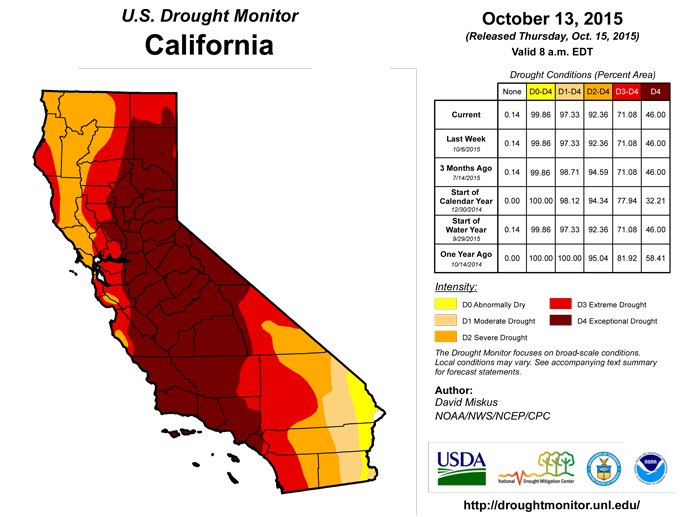
After last week’s widespread and unseasonably heavy (0.5-1.5 inches) rains in southern and eastern California and western and northern Nevada (locally to 2 inches), more typical dry and warm weather returned to the region. There were no changes made this week. The recent wet weather did nothing to offset the long-term drought, but may have aided in the suppression of wild fires as September and October are normally the biggest months for fires in California.Lower Mississippi Valley and Southern Plains
Although relief from moderate to heavy (2-5 inches) rains came to western and southwestern Texas this week, little or no rain once again fell on central and eastern Texas, and most of Oklahoma, Arkansas, Louisiana, and Mississippi – as the lack of rain also held true for October to date. The current 100% turn-around from record wet April-June rains that eliminated long-term drought and hydrological shortages in the southern Plains has continued since early July, producing widespread severe to extreme short-term drought at the 2- and 3-month time periods. At 90-days, rainfall totals of 0.5-2 inches in central and northeastern Texas, southern Oklahoma, northern Louisiana, southern Arkansas, and west-central Mississippi have translated into 5-25% of normal precipitation, deficits of 6-12 inches, and SPI values of -1.6 and less (D3 and D4). Similarly, 3-month totals exceeding 2 inches but still much-below normal encompassed most of Texas, southern sections of Oklahoma and Arkansas, northern two-thirds of Louisiana, and central Mississippi amounted to 25-50% of normal precipitation, shortages of 4-10 inches, and SPIs of -1 and less (D2 and D3). In Texas, average county precipitation percentiles were calculated for several different short-term periods (60, 75, 90, 105, and 120 days), resulting in values that were worse than depicted. Accordingly, a general 1-category deterioration was made to many areas of central and eastern Texas and southern Oklahoma, while 2- and 3-month SPI values, percentages, and deficits in Louisiana, Arkansas, and Mississippi guided widespread deterioration in these states. Farther north in southeastern Kansas and northern sections of Oklahoma and Arkansas, a very dry 30-days accompanied by strong winds and low humidity has led to a rapid drying of topsoil moisture, thus D0 was added.According to USDA/NASS, statewide October 11 moisture declined from last week except in Texas (from rains in west Texas). The percent topsoil/subsoil moisture short to very short included: Texas (63/61), Oklahoma (53/56), Arkansas (82/79), Louisiana (80/71), and Mississippi (81/82). The statewide percent of pasture and range conditions rated very poor or poor included: Texas (41), Louisiana (41), Arkansas (37), Mississippi (37), and Oklahoma (19). In west-central Texas, field reports included pastures drying up and livestock grazing well below normal, farmers unable to plant small grains due to dry conditions, some producers using supplemental feed a month to 6 weeks earlier than normal, and cotton harvests below normal. In southwest Arkansas, D4 was expanded to include Union and eastern Columbia counties where El Dorado has recorded 0.04 inches since August 22 (1%) and 0.67 inches since July 4 (6%). D3 was pushed into Sevier County where Dequeen has reported 0.38 inches since Sep. 9 (9%) and only 1.55 inches since July 7 (15%). In northern Louisiana, D4 was expanded into Bienville, Jackson, and Ouachita parishes where all SPIs at 30-60-90-120 days were less than -2.5 (D4). At Monroe, only 0.09 inches fell since Sep. 10 (2%), and 1.16 inches since July 4 (10%). The July-September period was the driest on record, and no rain has fallen during October yet. A number of wild fires have occurred in across portions of east Texas and northern Louisiana recently, enhanced by the dryness, gusty winds, and low humidity. Overall, a general 1-category degradation was made to Louisiana’s climate divisions (CDs) 1-5 with the rolling 90-day SCIPP drought tool showing the first or second driest on record for these 5 CDs during this time of year. In Mississippi, field reports have mentioned that winter grazing fields have not been planted, and the ones that were need to be replanted, crop yields are down, cattle producers are feeding hay much earlier than usual due to loss of green forage, general farm ponds have receded and are low, and many established landscape trees and shrubs are showing damage.
In contrast, western Texas (Rio Grande Valley and southern High Plains) saw widespread showers and thunderstorms, with up to 6-8 inches of rain in Maverick, Kinney, Zavala, and Uvalde counties (where D3 went to D0). The heaviest of rains mostly fell on non-drought areas of eastern New Mexico and western Texas, although the western D0 and southwestern D1 edges were shaved back where at least an inch fell, especially in the Rio Grande Valley.
Midwest
Similar to the Delta, October (and the past 30-days) has been quite dry across portions of the Corn Belt, especially in the eastern Dakotas, eastern Nebraska, southern Minnesota and Wisconsin, Iowa, northern Illinois and Indiana, Missouri, and western Kentucky. This short-term dryness comes after a wet July and somewhat wet August in many areas, thus 60- and 90-day shortages are not as widespread and severe as the Delta and southern Great Plains. As previously mentioned, limited dryness and warmth are generally good for the maturation, dry down, and harvesting of summer crops, but too much of this can degrade pastures, decrease soil moisture, and exacerbate wild fires. Using the 2- and 3-month tools and short-term blend indices, D0 was expanded in central Illinois, southwestern Indiana, western Kentucky and Tennessee, south-central Missouri, southwestern Wisconsin, and northern and central Minnesota, with D1 added or increased in southwestern Indiana (D1 reassessed and adjusted westward), south-central Missouri, western portions of Kentucky and Tennessee, southwestern Wisconsin (July 1 deficits of 4-7 inches), and northwestern Minnesota. The new D1 areas were added where the 90-day SPI was -1.6 or lower (D3). The 0.5-1 inches of rain that fell across the western Great Lakes region was not enough to eliminate short-term departures, hence status-quo here.New England and mid-Atlantic
After last week’s widespread moderate to heavy rains (especially in northern and southern sections), only light rains (0.5 to an inch) fell across most of the region, with even less (under 0.2 inches) from north-central Pennsylvania eastward into Massachusetts, and from west-central Maryland southward into northern North Carolina. Some very slight removal of D0 was made in upstate New York where 1.5 to 2 inches of rain was enough to eliminate short-term (60- to 90-days) dryness. In southern West Virginia, 0.5 to 1.5 inches was also enough to trim back D0 as short-term deficits were eliminated. Instantaneous, 1-, and 7-day average USGS stream flow quickly dropped back into the below to much-below percentile classes (where the D1 areas are located) after briefly rising to above normal after last week’s rains. Elsewhere, stream flows generally remained in the normal to above classes.Northern and Central Plains
Short-term dryness (less than 25% of normal precipitation at 30-days, less than 50% at 60-days) warranted an expansion of D0 westward into south-central North Dakota and southward into northeastern South Dakota. The dryness, combined with strong winds and high temperatures, quickly dried out crops and produced blowing dust, with some wind-driven fires over the weekend. Several stations in northeastern South Dakota had one of the ten driest Septembers on record, ranging from Watertown (0.27”) to Clear Lake (0.63”), while stations in the southwest were similarly dry (Rapid City 0.25”, Newell 0.04”, Hill City 0.26”). Several locations in the Plains also set record October highs (degF) including 98 at Broken Bow and Norfolk, NE; 97 at Grand Island and Hastings, NE, Wheaton, MN, and Fargo, ND; 95 at Sisseton, SD; 94 at Pueblo, CO; and 88 at International Falls, MN. Farther south, light rains during the past 2 weeks were not enough to offset development of short-term dryness in northern and southeastern Kansas as warm and windy weather is impacting fall planted crops such as winter wheat and canola. In northwestern Colorado, D0 was introduced to Grand, Routt, Moffat, and Rio Blanco counties based upon low SPIs at 30- and 90-days, and degrading vegetative health and soil moisture conditions.Pacific Northwest and Northern Rockies
Moderate to heavy precipitation (2-5 inches) fell on western Washington, especially the Olympic Peninsula and northern Cascades, continuing a trend of consistent precipitation (near to above normal amounts) during the past 3 months. Since these two areas had 90-day surpluses and near to above normal average USGS stream flow values, they were improved a category (from D2 to D1), and the Impact type changed to L (from SL). Elsewhere, the precipitation was not great enough (less than an inch) to make any improvements to the drought (coastal Oregon, southern Cascades, extreme northern Rockies), while little or no precipitation fell (interior Oregon and Washington, southern Idaho), keeping them status-quo.Southeast
More unwanted rain (1 to 3 inches) fell on saturated South Carolina, aggravating flood relief in the state. Elsewhere, 0.5 to 2 inches were measured across northeastern Mississippi, northern sections of Alabama and Georgia, eastern Tennessee, most of Kentucky, and southern North Carolina. Unfortunately, much of this precipitation fell on non-drought areas, so the only improvement was removal of a small D0 in eastern Kentucky (along with southern West Virginia as previously mentioned). The Day 7 rains (0.5-1 inch) in central Kentucky were enough to prevent a 1-category downgrade, but lower totals (less than 0.5 inches) in western Kentucky and northwestern Tennessee were not enough as D1 was drawn where 60-day precipitation was under half of normal, accumulating deficits of 4-6 inches. In southern Georgia, little or no rain called for some slight degrading of conditions in Worth, Atkinson, and Coffee Counties, while Carroll and Heard Counties in west-central Georgia (on the Alabama border) became abnormally dry. In Alabama, light scattered showers in central and western sections did little to aid conditions as USGS stream flows dropped to below normal levels, with some much below normal readings in western areas. With various tools and indices at 60- and 90-days showing D1 or worse, D1 was expanded into western Alabama and the extreme western Florida Panhandle, and D0 edged eastward in east-central Alabama and west-central Georgia. Mississippi will be discussed in the Lower Mississippi Valley and Southern Plains summary, and the remaining D0 and D1 areas in north-central and southern Florida were unchanged.Southwest
Scattered light showers (less than 0.5 inches) were observed across most of Arizona and southwestern New Mexico, with heavier totals (0.5-2 inches, locally to 4.5 inches) measured in southern and eastern New Mexico (in association with the rains in west Texas and the Rio Grande Valley). Nearly all of the significant rains, however, fell on non-drought areas, except for D0 in southern Chaves and eastern Otero counties. This small D0 was trimmed somewhat as the heavier rains fell to its east and west, still leaving deficits at 60-, 90-, and 180-days, and year-to-date. Elsewhere, decent precipitation from last week was enough to offset this week’s drier weather, keeping conditions unchanged.Looking Ahead
For the upcoming 5-day period (October 15-19), a rather dry weather pattern should exist east of the Rockies, with only light to moderate precipitation expected in the Great Lakes region and New England, and extreme southern Florida. In the West, however, widespread and heavy rainfall (1-3 inches) is possible in the Southwest (southeast California, Nevada, Arizona, Utah, western New Mexico, southwest Colorado) and western Washington, with lighter amounts in Idaho, Oregon, and western Wyoming and Montana. Temperatures should average below normal in the eastern third of the Nation, with much above normal readings from the Plains westward.For the ensuing 5 days (October 20-24), the odds favor above-median precipitation throughout much of the middle third of the U.S., in the Northwest and Southeast, and southern Alaska, with a tilt toward sub-median precipitation in California, along the mid-Atlantic and New England coasts, and western Alaska. Above-normal temperatures are favored in much of the lower 48 States and southern Alaska, with only near-normal readings expected in northern Alaska, the Carolinas, and New Mexico.
Author(s):
David Miskus, NOAA/NWS/NCEP/CPC
Dryness Categories
D0 ... Abnormally Dry ... used for areas showing dryness but not yet in drought, or for areas recovering from drought.Drought Intensity Categories
D1 ... Moderate DroughtD2 ... Severe Drought
D3 ... Extreme Drought
D4 ... Exceptional Drought
Drought or Dryness Types
S ... Short-Term, typically <6 months (e.g. agricultural, grasslands)L ... Long-Term, typically >6 months (e.g. hydrology, ecology)
Source: National Drought Mitigation Center

