


Includes Eastern Mariposa, Madera and Fresno Counties and Yosemite National Park
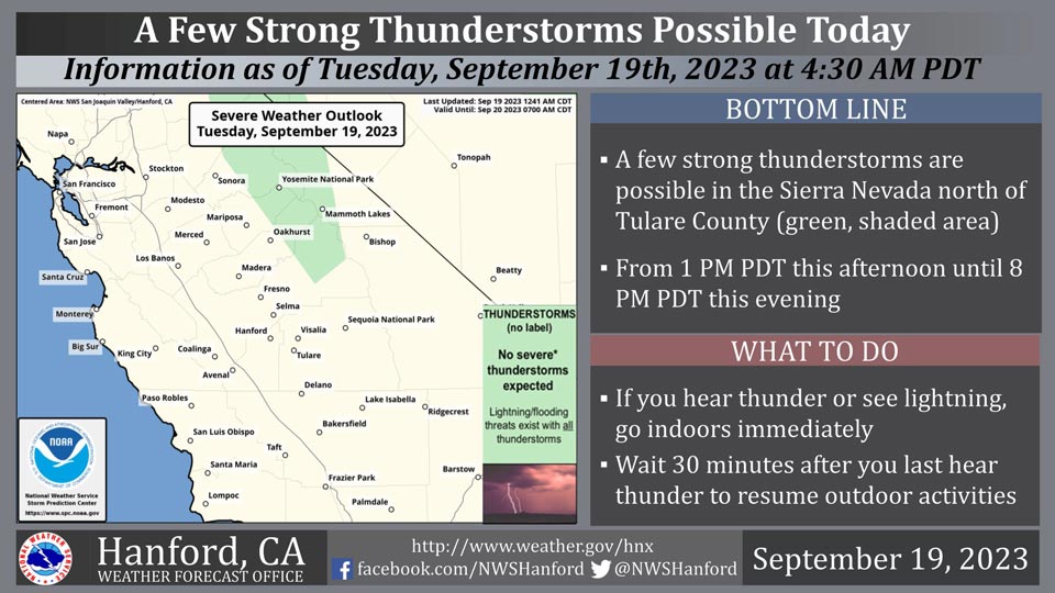
September 19, 2023 - National Weather Service Hanford Office reports a few strong thunderstorms are possible in the Sierra Nevada north of Tulare County from 1:00 P.M, this afternoon until 8:00 P.M. this evening.
Wind gusts near 45 miles per hour and small hail are a couple of hazards associated with strong thunderstorms.
In addition to dangerous cloud to ground lightning strikes, any thunderstorm can produce intense rainfall rates, leading to localized flooding.
Area Forecast Discussion
National Weather Service Hanford CA
110 AM PDT Tue Sep 19 2023
.SYNOPSIS...A warming trend will take place through Wednesday
before an upper trough pushes through the area on Thursday,
bringing a period of increased winds along with another cooling
trend. A cooler and dry airmass will then prevail over the area
Friday through the weekend.
&&
.DISCUSSION...The offshore upper low which has provided for an
onshore flow over central CA which brought a cooling trend to our
area over the past few days is dropping further southward and
will have less influence over our area as the SREF shows that it
will continue to drop southward off the Socal coast today then
track inland across Socal on Wednesday. The result of this will be
a warming trend across our area today and Wednesday although
temperatures will remain below daily climatological normals.
HRRR indicating enough instability remains present over the
Sierra Nevada from Fresno County northward for isolated afternoon
and early evening showers and thunderstorms today and again on
Wednesday; otherwise, our area will remain dry.
A fairly strong upper trough is progged to drop into the PAC NW
on Wednesday then drop further southward into Norcal on Thursday
and Thursday night before shifting eastward across the Great Basin
area on Friday. While most of the moisture and dynamics
associated with this system are expected to remain to the north
of our area, a chance of showers exists over the SIerra NEvada
from Fresno County northward with the snow level lowering to
around 8000 feet by the time a drier airmass pushes in on Thursday
evening. Other impacts that are expected from this system will be
a period of increased wind across the Kern County Mountains and
Deserts on Thursday. EFI values are between 0.8 and 0.95 with a
shift of tails between 0 and 1 for Thursday across much of the
Kern County Mountains and Deserts on Thursday and NBM is showing
wind gusts between 45 and 55 mph across some of the usual windy
locations in eastern Kern County Thursday afternoon and evening.
Another cooling trend is also anticipated as a cold front will
accompany the trough on Thursday which will result in the coolest
day across our area since September 3.
Here are NBM probabilities for afternoon highs remaining below 80
DEG F on Thursday at select locations across the San Joaquin
Valley:
Merced: 24%
Madera: 29%
Fresno: 39%
Hanford: 39%
Bakersfield: 24%
A shortwave ridge is progged to push inland into CA on Friday
then shift further inland over the weekend. The result of this
will be dry weather and a warming trend across our area with
temperatures rising back up to near normal values. Another trough
is expected to swing through CA on Monday afternoon and evening,
but the deeper moisture and stronger dynamics are expected to
remain to the north of our CWFA which will minimize precipitation
chances for our area.
&&
.AVIATION...VFR conditions will prevail across the Central CA
interior for the next 24 hours.
&&
.AIR QUALITY ISSUES...None.
&&
.CERTAINTY...
The level of certainty for days 1 and 2 is high.
The level of certainty for days 3 through 7 is medium.
Certainty levels include low...medium...and high. Please visit
www.weather.gov/hnx/certainty.html for additional information
and/or to provide feedback.
&&
.HNX WATCHES/WARNINGS/ADVISORIES...None.
Source: NWS
