


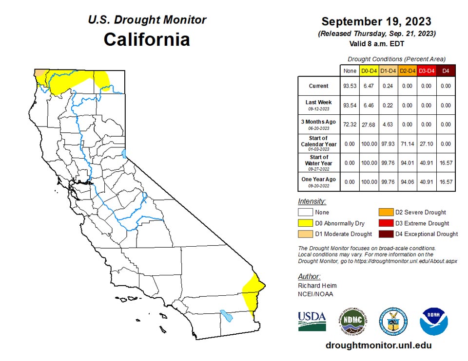
California and National Drought Summary for September 19, 2023
Summary
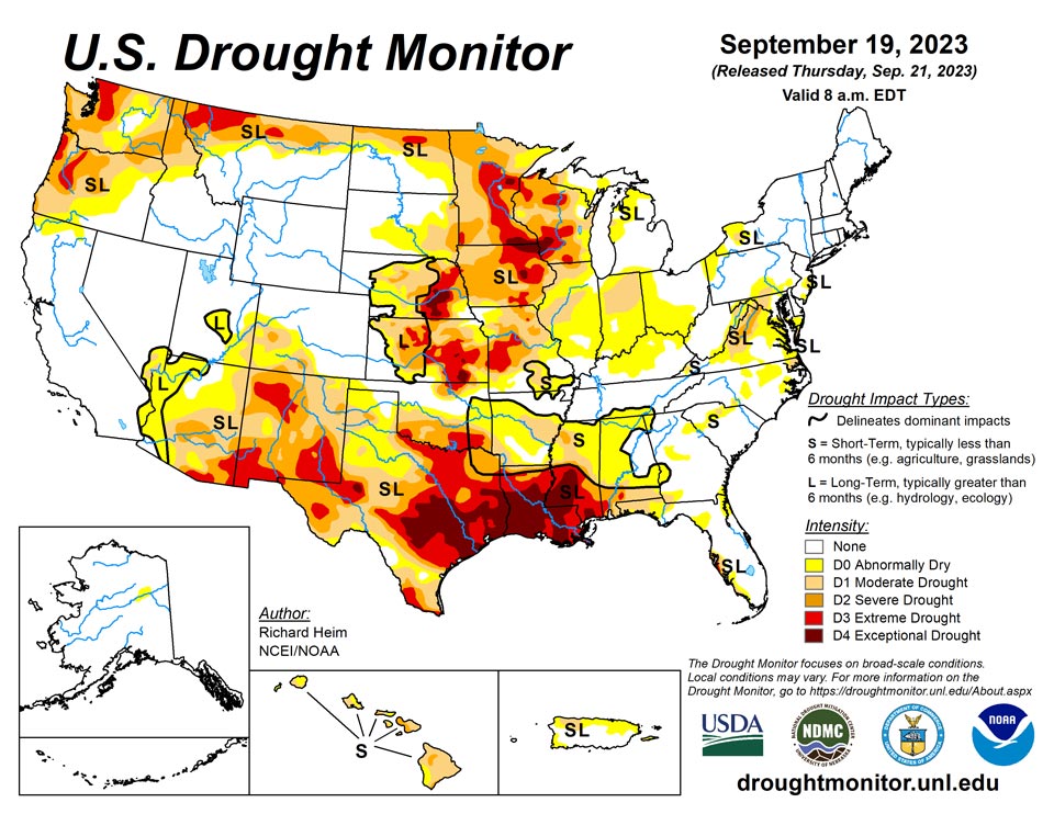
September 21, 2023 - Several Pacific weather systems moved through the jet-stream flow during this U.S. Drought Monitor (USDM) week (September 13-19). The upper-level circulation still consisted of an upper-level ridge over the western contiguous U.S. (CONUS), but it was weakened by the traversing Pacific weather systems. The ridge kept most of the western U.S. dry with warmer-than-normal temperatures from northern California to Montana. Cold fronts and surface low-pressure systems, that accompanied the weather systems, brought rain to the Southwest, southern Plains, Southeast, and Northeast. Heavy rain fell across western to central Texas, improving drought conditions. The rain in the East fell mostly on non-drought areas. The fronts kept temperatures cooler than normal from the Southwest to most of the southern Plains and across much of the country from the Mississippi River to East Coast – only the Gulf of Mexico coast and New England had a warmer-than-normal week. In addition to getting rain from frontal systems, parts of New England were soaked by the remnants of Hurricane Lee over the weekend. The northern Plains and parts of the central Plains, the Great Lakes, and the Mississippi and Ohio Valleys had a drier-than-normal week. The dryness this week was a continuation of dry conditions that have lasted for several months – in some cases for years – across parts of the country and that have dried out soils across more than half of the CONUS. According to U.S. Department of Agriculture statistics, 58% of the nation’s topsoil moisture and 59% of the subsoil moisture was dry or very dry. For topsoil moisture, based on data going back to 2015, this amount is second only to the drought of 2022, which peaked at 68%. The continued dry conditions resulted in expansion or intensification of drought and abnormal dryness across parts of the Mississippi and Ohio Valleys, Mid-Atlantic states, and Pacific Northwest.
Northeast
Precipitation in the Northeast ranged from less than a tenth of an inch in western portions to over 5 inches in Maine. Bands of 2+ inches occurred in West Virginia and from Delaware to Massachusetts. The driest areas were in western New York and Pennsylvania, and parts of Maryland. Abnormal dryness was removed from Delaware, but it expanded in western New York, parts of Pennsylvania, and parts of West Virginia. Moderate drought expanded in parts of Pennsylvania, Maryland, and western New York.
Southeast
Half an inch of rain was widespread across the Southeast with areas of 2+ inches. The heaviest rains fell mostly on non-drought areas. There were dry areas, with less than a fourth of an inch of rain, in parts of Virginia, North Carolina, Mississippi, Georgia, and Florida. D0 and D1 expanded in parts of northern and southwestern Florida and parts of Virginia; D2 expanded in Virginia and spilled over a little into Maryland. D0 contracted in parts of Georgia and South Carolina but expanded in other parts, with D1 slightly expanding in southwest Georgia. The effects of the heat and dryness of the summer and arly fall culminated in D0 and D1 expanding over a large part of Alabama. According to U.S. Department of Agriculture (USDA) reports, 41% of the topsoil moisture was short or very short of moisture (dry or very dry) in Alabama and Virginia. The percentage of subsoil moisture short or very short was 48% in Virginia and 41% in Alabama.
South
A large part of Texas received over 2 inches of rain this week. These areas included western to central Texas and parts of the Southeast and Far South. Over 5 inches of rain was reported at stations near Lubbock, Austin, Houston, and Galveston Bay, with the CoCoRaHS station at Nassau Bay 0.9ENE reporting 9.57 inches. The rain resulted in the contraction of D1-D4 in western to central Texas and in the southeast and far south sections of the state. Areas of half an inch to 2 inches of rain occurred over parts of western and southern Oklahoma. But most of Arkansas and Mississippi, parts of Louisiana and eastern Oklahoma, and much of the Rio Grande Valley were dry this week. The compound effects of the excessive heat and dryness of the summer and early fall prompted expansion of abnormal dryness and moderate to exceptional drought in Mississippi, Louisiana, northeastern Texas, and southeast Oklahoma, with abnormal dryness and moderate drought expanding in Arkansas and eastern Oklahoma. The high evapotranspiration and lack of rain has dried out soils and resulted in impacts that include low or dry streams and cattle ponds, desiccated pasture and cropland, and stressed vegetation dropping leaves. Reports include: hay and grasses are short and insufficient for cattle; soils are so dry that the ground is as hard as concrete. Reports like this are typical across the region. According to USDA reports, topsoil moisture is short or very short across 80% of Louisiana, 74% of Mississippi, 72% of Oklahoma, 69% of Arkansas, and 59% of Texas. The subsoil moisture statistics are: 87% Louisiana, 73% Oklahoma and Texas, 67% Mississippi, and 55% Arkansas. Over 60% of the pasture and rangeland is in poor to very poor condition in Texas (71%) and Louisiana (68%), and over 40% in Oklahoma (49%) and Mississippi (41%).
Midwest
Showers associated with the cold fronts brought areas of rain to parts of Ohio and western parts of the Midwest region, with precipitation totals of half an inch or more. Locally 2 inches or more of rain fell in parts of northern Illinois and southern Wisconsin. But large parts of the region continued dry this week. Areas of drought and abnormal dryness were pulled back where the heaviest rains fell in northeast Minnesota and northern Illinois. Continuing dry soils and the compounded effects of 6 months of below-normal precipitation and summer heat resulted in the expansion of moderate to exceptional drought in parts of the Upper Mississippi River Valley states, and abnormal dryness and drought in parts of the Ohio River Valley states. Low creeks and ponds and browning of crops and lawns have been reported in Indiana. Reports like this are typical across the region. According to USDA statistics, topsoil moisture is short to very short across 79% of Iowa, 75% of Minnesota, 68% of Illinois, 64% of Wisconsin, 62% of Missouri, 56% of Indiana, and 43% of Ohio and Kentucky. The subsoil moisture statistics are: 80% Iowa, 76% Minnesota, 68% Wisconsin, 66% Illinois, 63% Missouri, 55% Indiana, and 42% Ohio. In Minnesota, 66% of the pasture and rangeland was in poor to very poor condition, with the statistics 48% for Iowa, 45% for Wisconsin, 44% for Missouri, and 41% for Illinois.
High Plains
Half an inch to locally 2 inches of rain fell over western and southern parts of the High Plains region, mostly in Colorado, southern Kansas, and parts of Nebraska. But most of Wyoming, the Dakotas, Nebraska, and Kansas were dry this week. The rain trimmed D0 in southern Colorado and contracted D0-D1 in southwestern Kansas. D0 and D3 expanded in eastern Kansas. D0 expanded in parts of southwest Nebraska, but the compounded effects of excessive summer heat and overall dryness over the last 1 to 2 years resulted in expansion of D3 and D4 in parts of southeast Nebraska. Sporadic summer showers have not had much of an impact on the multi-year drought, with low soil moisture continuing and stressed vegetation as seen on satellite-based indicators. A farmer/rancher in Nuckolls County, Nebraska reported stock ponds had never gone dry in his 65 years living in the county until this summer and his crops were all burned up. Reports like this are typical across the region. According to USDA statistics, 50% or more of the topsoil moisture was short or very short in Kansas (68%), Nebraska (60%), North Dakota (51%), and South Dakota (50%), and 50% or more of the subsoil moisture was dry or very dry in Kansas (75%), Nebraska (65%), and North and South Dakota (52% each). Half (50%) of the pasture and rangeland in Kansas was in poor to very poor condition.
West
Half an inch to locally 2+ inches of rain fell over parts of Arizona, New Mexico, and Utah, but most of the West received no rain this week. High evapotranspiration due to persistently hot temperatures, low streamflow and soil moisture, and lack of precipitation over 1-month to 12-month time scales resulted in the expansion of D2 and D3 in northwest Washington, expansion of D2 in eastern Washington and the Idaho panhandle, and expansion of D1 and D2 and the introduction of D3 in western Oregon. Rain from weather systems in past weeks, especially the remnants of Hurricane Hilary, resulted in contraction of D1 in central Oregon, D0 and D1 in Utah, and D0 to D3 in western Montana. While parts of New Mexico received rain this week, other parts were dry. The weather system that dumped rain on Texas also soaked east-central New Mexico, so drought contracted there. But prolonged dryness resulted in expansion of D1 and D2 in central to northeast New Mexico and D3 in northwest and southern parts of the state, as well as D3 expansion in adjacent southeast Arizona. According to USDA reports, more than two-thirds of the topsoil was short or very short of moisture in New Mexico (87%), Washington (83%), Montana (82%), and Oregon (74%), and more than two-thirds of the subsoil moisture was short or very short in New Mexico (87%), Montana (79%), Washington (78%), and Oregon (75%). Half or more of the pasture and rangeland was in poor or very poor condition in Washington (65%) and Arizona (57%).
Caribbean
Some rain fell over parts of Puerto Rico this week, but for the most part it was less than the weekly normal. Temperatures continued hot, with maximum temperatures in the mid-90s prompting excessive heat warnings. High evapotranspiration, low streamflow and soil moisture, and persistent dryness over the last several months prompted expansion of D0 in western Puerto Rico and the addition of new D0 in the east.
Abundant rains fell on the U. S. Virgin Islands last autumn (September – November 2022), but since December of last year, rainfall totals have consistently been well below normal. Well-above-normal to record-high temperatures have accompanied the dryness starting between late April and early July 2023 (depending on location), increasing the rate and extent of surface moisture and groundwater depletion. And for roughly the past 2 months, winds have peaked at 20 mph or higher on most days, further aggravating the degrading moisture budget.
The confluence of these conditions for an extended period led to worsening the drought classification to D4 (exceptional drought) on both St. Croix and St. Thomas -- the most extreme designation possible in the Drought Monitor (note that D4 means conditions this extreme occur about once every 50 years based on local climatology; it does not necessarily imply the worst conditions on record). Meanwhile, farther to the east, St. John is also experiencing problematic dryness, but conditions are not as extreme. Last week, enough deterioration was observed over the prior few weeks to prompt worsening the classification from D1 to D2 (severe drought), and D2 remains the designation this week.
Of the three U. S. Virgin Islands assessed in the Drought Monitor, St. Croix is probably experiencing the most extreme conditions, at least according to the statistics. Over the past 9.5 months, rainfall deficits are very slightly better than on St. Thomas; however, almost 25 percent of the 9.5-month-total fell on one day, significantly reducing any benefit the rainfall might have induced. In addition, the heat has been more extreme on St. Croix than elsewhere, with near-record to record high temperatures common over the past couple of months.
From December 1, 2022 to September 19, 2023 St. Croix received 13.07 inches of rain, which is almost a foot lower than (and less than 53 percent of) normal [24.83 inches]. And of this total, 3.19 inches fell on one day (June 29), which limits how much benefit the rainfall can provide. Discounting this day, the 9.5-month rainfall total would be 9.88 inches, which is barely more than 40 percent of normal. This past week, a mere 0.06 of an inch was reported, making the September-to-date total just 0.23 of an inch (less than 8 percent of normal). Rainfall has totaled less than 20 percent of normal for 4 of the last 10 months (including September-to-date). In addition, much-above-normal temperatures have accompanied the dryness since late April, with frequent periods of near-record to record heat since early August. Since April 27, temperatures have averaged 2.3 deg. F above normal, with the lack of surface moisture allowing daytime highs to reach extreme to unprecedented levels more recently. Since April 27, only one day has averaged cooler than normal. Daily record high temperatures were tied or exceeded on 19 of the 24 days from August 27 – September 9, and records were noted on 12 of the 13 days August 5 – 11. The high reached 96 deg. F on August 14, which was the first time above 95 deg. F since October 1995. Of 724 months on record since 1951 at the airport, only 3 months saw temperatures peak higher (98 deg. F in October 1972, 97 in June 1993, and 97 in October 1995). More recently, daily highs reached 96 deg. F or higher on 3 of the first 17 days of September 2023. The most anomalous day was September 12. With a high of 95 deg. F and a low of 85 deg. F, the average temperature was 7 deg. F above normal.
The drought, exacerbated by heat and wind, has significantly impacted agriculture. Farmers across the island report localized, sporadic rain, but it is not penetrating the hard, hot, and dry soil. Over 200 head of cattle and 20 horses have died from these conditions, and egg production is only about half of normal due to the affects of the heat and dryness on chickens. Farm animal populations have been kept thin to reduce the amount of water needed, and hay is being purchased and stored in anticipation of food shortages created by sparse, poor-quality grasses. The Adventure 28 Well has been monitored for several years now. According to the U. S. Geological Survey (USGS), water was less than 10 feet below the surface in mid-November 2017. Frequent periods of drought have caused the water level to drop over the past few years. After abundant September – November 2022 rainfall, the water level rose to about 25 feet below ground level, but the last 10 months of worsening drought have caused the water level to drop to over 34 feet below ground level on September 19.
On the last 2 days of the period (September 18-19), King Airport finally reported a decent amount of rain (1.30 inches); this was the wettest 2-day period since November 4 – 5, 2022, when 3.63 inches fell. The rainfall, however, didn’t even bring September-to-date totals up to half of normal. On September 19, moderate to heavy rains (0.8 to 1.8 inches) fell on some areas near Cruz Bay and Frederiksted, but most areas received less. For the roughly 9.5 months since December 1, 2022, King Airport recorded 13.72 inches of rain, which is slightly under half of the normal (27.92 inches). Less than half of normal rainfall was reported for 5 of the last 9 full months. Above-normal temperatures have exacerbated drought impacts for the past 2.5 months, although temperatures have not been as extreme as those reported on St. Croix. Since July 1, temperatures have averaged almost 1.4 deg. F above normal. No daily record highs were set, but for September 12 – 14 and 16, record high minimums were recorded (82 deg. F on the 16th; 84 deg. F the other days).
Farmers on St. Thomas report increasing concerns with ponds slowly evaporating, but also that the limited and sporadic rain has helped recharge soil moisture a little. Many are still not planting due to the drought, heat, and wind. Efforts to increase water efficiency are underway to prepare for continued drought. Orchards and fruit trees have been watered as much as possible, and so far, large-scale losses have not occurred. Herders are rotating livestock, separating males from females to keep herd populations down due to the lack of forage and water. They are purchasing grain and hay to ensure enough food for the animals. At the Grade School 3 Well – monitored since 2020 – water reached 1.48 feet below ground level in early November 2022 after a few wet months but had dropped down to 16.63 feet below ground level in early August due to the drought and heat. It has rebounded somewhat in September, but at 13.17 feel below ground level on September 19th, it’s way below the levels observed last autumn.
Conditions have not been as bad on St. John, where severe drought (D2) exists. But still, significant impacts from the heat, drought, and wind have been reported. Since December 1, 2022, rainfall has totaled closer to normal than on areas farther west. Windswept Beach reported 23.82 inches during the last 9.5 months, which is close to 74 percent of normal (32.35 inches). Amounts have been a little lower since February 1, with slightly more than two-thirds of normal recorded. These amounts are substantially wetter than on St. Croix and St. Thomas, thus the less extreme drought classification. Farmers report that row and specialty crops are generally in fair condition with enough water to keep them from being lost. There is a concentration on microgreens, fruit, and quick crops which are being rotated frequently, and while conditions are not optimum, farmers have generally been able to keep production from dipping too severely. Land is being prepared for the next few months, hoping that additional production during the wetter time of year might make up for sales lost due to the ongoing drought. At the Susannaberg DPW well – monitored most of the time since September 2016 – water actually reached ground level in late 2017 but has been on a general downward trend since. Last year’s wet autumn allowed water to climb to 7.55 feet below ground level on November 25, 2022, but the ensuing drought has caused the top of the water to retreat to more than 20 feet below ground level.
Pacific
Beneficial rain fell in Alaska this week, eliminating D0 areas in the east and panhandle. Only a small area of D0 remained in the east central region near Yukon Flats.
Hawaii was mostly drier than normal this week, but no change was made to the depiction.
Along the chain of islands stretching across (west to east) Palau, The Mariana Islands, Micronesia, and the Marshall Islands, central and western sections are free from any notable dryness, but several locations from eastern Micronesia across the Marshall Islands are abnormally dry (D0). This includes two locations newly sliding into D0 this week (Kwajalein an Ailinglapalap). Well to the south, Tutuila on American Samoa remains in moderate drought (D1) despite a few very wet days in early September. This is the only drought noted among the U. S. Affiliated Pacific Islands.
Several days of reports are missing from Koror, but the dozen or so days of reports through September 19 add up to almost 9 inches for the month to date. With anywhere from 13.4 to 26.9 inches of rain during each of the prior 4 months, the Republic is free of any impacts from dryness, and the past few months of heavy rain will probably keep any problems at bay even if conditions dry out during the next couple of months.
Across the Marianas, the first 19 days of September have been a little drier than normal at Guam and Rota, where totals are under 7 inches for the months so far. Saipan has received over 9 inches of rain and is above normal for the month. During August, the three aforementioned locations recorded anywhere from 18.2 to 19.5 inches of rain, squelching any potential concerns about dryness for the time being.
Similar to the Marianas, most locations across Micronesia are drier than normal for September 1-19. Five sites (Yap, Kosrae, Lukunor, Pingelap, and Rumung) recorded 52 to 73 percent of normal for this period (generally 2.4 to 5.0 inches of rain, except 7.15 inches at Kosrae. But from June through August, rainfall was abundant across almost all of Micronesia, with anywhere from 10 to 31 inches reported at every location each month. Exceptions included a dry June and July at Fananu (12.28 inches, below the optimal amount of 8 inches both months), but a wet August there eased any developing concerns due to dryness. In addition, August was dry at Pingelap. About 80 percent of normal fell there during July, which was well above the amount needed to keep up with water usage. But August brought only 54 percent of normal rainfall (7 inches, below the optimum amount), and so far in September, 56 percent of normal (5 inches) has been reported. At that rate, September would also produce less rainfall than is generally needed to keep up with demand, although only by a few tenths of an inch. The subnormal rainfall for roughly the past 3.5 months, and with rain falling at a rate short of the preferred 8 inches per month during August 1 – September 19, abnormal dryness (D0) persists at Pingelap. Farther south, Kapingamarangi has endured several periods of significant drought over the past few years but concerns about recurring drought have been alleviated for the time being. Through September 19, year-to-date rainfall totaled 141.83 inches, far exceeding the normal of 98.48 inches. This is the wettest 9-month period since just over 148 inches fell March – November 2019. In contrast, the driest such period was May 2020 – January 2021, when less than 33 inches fell. As a result, resurgent drought should not be a concern for the foreseeable future.
September is off to a dry start in most of the Marshalls. Over 13 inches of rain has fallen on Mili, but other locations report only 2.7 to 5.4 inches. Wotje reports 3.3 inches during this period, which is about two-thirds normal and on pace for well under the 8 inches needed to ensure rainfall is keeping up with water demand. Rainfall was closer to normal in August, but as Wotje is climatologically one of the driest locations across the Pacific Ocean, monthly totals were considerably below the preferred total of 8 inches. Above-normal rain fell during the prior few months, but totals were considerably less than most other sites due to the relatively dry climatology. Considering all these factors, Wotje remains abnormally dry (D0) as it was last week. Subnormal precipitation has also been observed in the western Marshalls at Kwajalein and Ailinglapalap. At Kwajalein, less than half of normal rainfall was recorded in July 2023 while both August and September-to-date report 70 to 76 percent of normal. All three months brought less than 8 inches to Kwajalein, although August was just slightly less. With only 4.88 inches of rain this month so far, enough of a rainfall deficit has accumulated to justify a classification of abnormally dry (D0) being introduced this week. Ailinglapalap has been wetter than that during the same period, but somewhat below-normal July and August rainfall has been followed by a September with only 2.76 inches of rain (41 percent of normal) during the first 19 days. These conditions – especially the short-term lack of rainfall – justify also introducing D0 at Ailinglapalap this week. Across the eastern Marshalls, Mili has been considerably wetter than most of the Nation during the past several months, and while only 3.17 inches of rain has fallen on Majuro so far this September, August totals of over 11 inches were sufficient to squelch any concerns about abnormal dryness for the time being.
Rainfall reported from Jaluit has been low enough for over a year to justify introducing D0 this week, but there are concerns that the location has had a dry bias during this period, with reports generally lower than the actual amount that fell. Reports indicate that below normal rain fell for 17 of the 19 months since May 2022, including 10 months with 75 percent of normal or less reported. This equates to monthly totals below the optimum amount of 8 inches for 11 of those months. These statistics easily justify introducing D0 but concerns about the accuracy of the data prompted setting Jaluit’s official classification to “no data” this week. We are investigating the potential error and hope to rectify the situation soon.
Following a few exceptionally wet days in early September, a pattern of below normal rainfall returned to Pago Pago last week. The Austral winter (June – August 2023) is a dry time of year in the territory, with normal rainfall of 18.63 inches. This year, however, only 13.71 inches fell, with a meager 2.26 inches observed in August (36 percent of normal). Early September brought a few days of very heavy rain to Pago Pago, with 7.87 inches reported September 6-12 – more than any full month since May 2023. Somewhat drier than normal conditions returned this past week, with 1.61 inches reported. Summing September 1-19, more than twice the normal amount of rain has fallen. But with drier than normal conditions prevailing during the summer, the scant amount of rain recorded during August, and reports of vegetative stress continuing in parts of Pago Pago despite the soaking rains earlier in September, moderate drought (D1) remains in place this week.
Looking Ahead
In the two days since the valid time of this USDM, rain has fallen across parts of the West, parts of the Plains to Mississippi Valley, and parts of Florida. For September 21-26, a strong weather system will slowly move out of the Rockies into the Plains and spread heavy rain across much of the Plains to Mississippi Valley, while a low-pressure system moves along the East Coast, spreading heavy rain to coastal areas, and a third Pacific weather system brings rain to coastal areas from northern California to Washington. Weekly precipitation totals could range from 1 to locally 5 inches or more in these regions. Other parts of the Far West, the Four Corners states, much of the Southeast, and the Appalachians to eastern Great Lakes are expected to receive little to no precipitation. Temperatures are expected to be warmer than normal across parts of the Plains to the Mississippi River Valley and Great Lakes.
The Climate Prediction Center’s (CPC) 6-10 Day Outlook (valid September 26-30) favors above-normal precipitation from northern California to North Dakota and across much of the Southeast, with below-normal precipitation centered over Colorado and extending from Missouri to the Great Lakes and New England. Odds favor near normal precipitation for Alaska. The outlook is for below-normal temperatures over southwest Alaska and the Far West in the CONUS, and above-normal temperatures from the Rockies to Appalachians and over northeast Alaska.
The temperature pattern favored in CPC’s 8-14 Day Outlook (valid September 28-October 4) is a continuation of that in the 6-10 Day Outlook, with cooler-than-normal temperatures extending to the Rocky Mountains and the warmer-than-normal area extending to the East Coast. The area favored for above-normal precipitation extends across the Great Plains, while the below-normal area extends to the Lower Mississippi Valley. Odds favor above-normal precipitation for most of Alaska.
Author(s):
Richard Heim, NOAA/NCEI
Richard Tinker, NOAA/NWS/NCEP/CPC
Dryness Categories
D0 Abnormally Dry—used for areas showing dryness but not yet in drought, or for areas recovering from drought.
Drought Intensity Categories
D1 Moderate Drought
D2 Severe Drought
D3 Extreme Drought
D4 Exceptional Drought
Drought or Dryness Types
S Short-term, typically less than 6 months (agriculture, grasslands)
L Long-term, typically more than 6 months (hydrology, ecology)
SL Area contains both short- and long-term impacts
Source: National Drought Mitigation Center
