


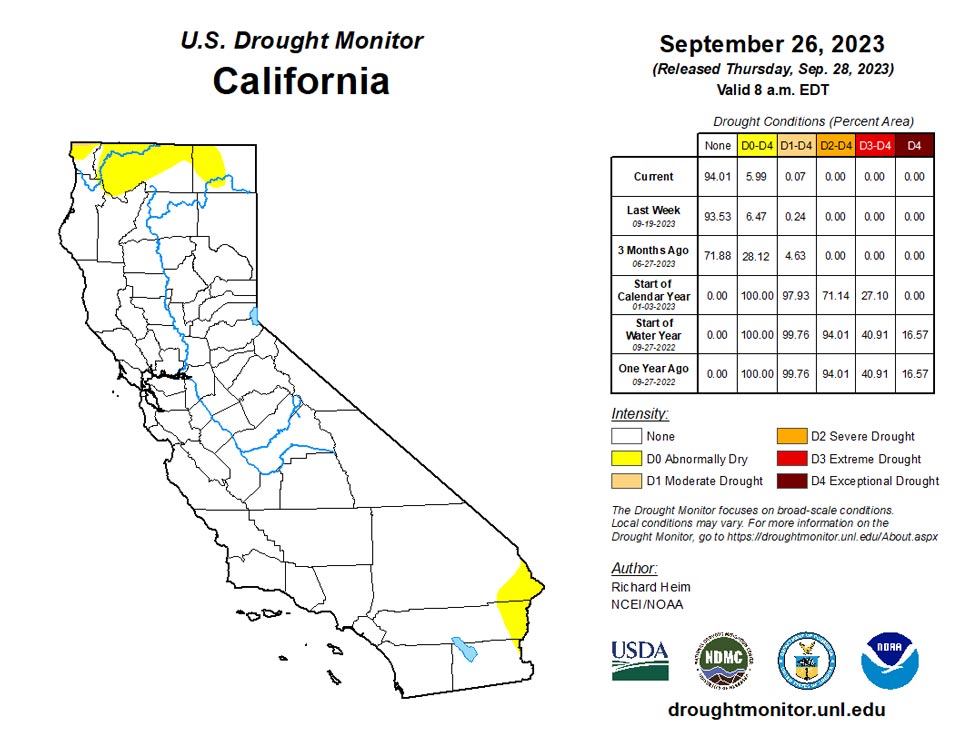
California and National Drought Summary for September 26, 2023
Summary
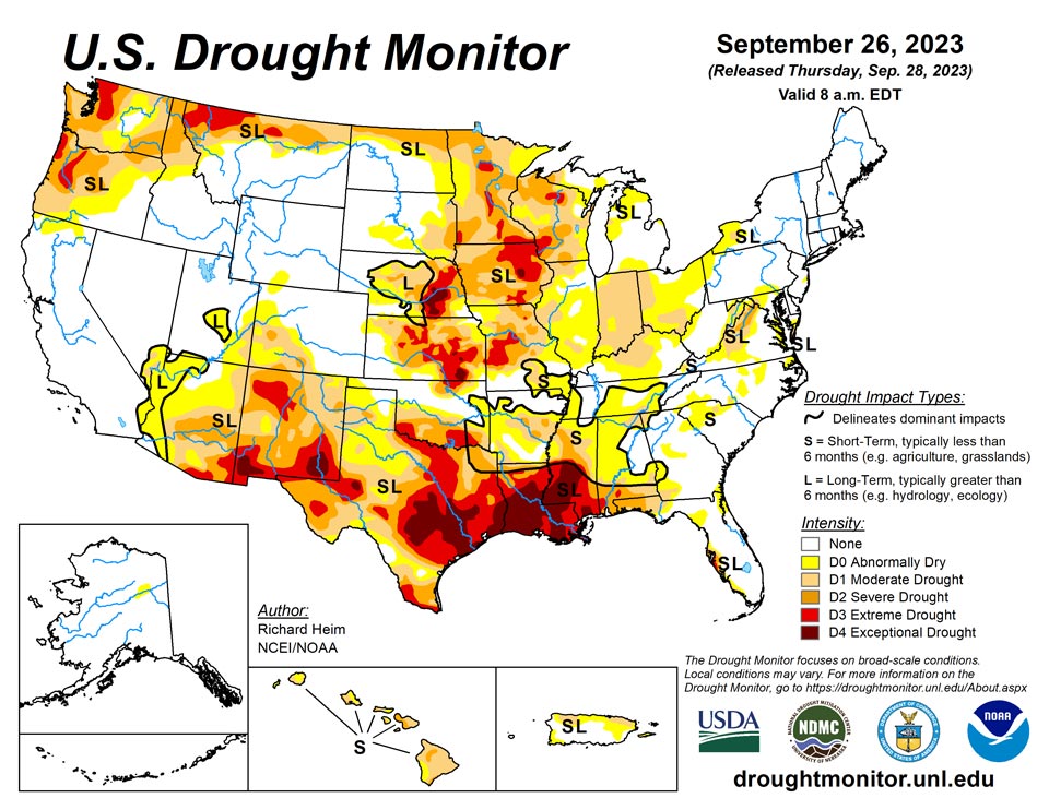
September 28, 2023 - The upper-level circulation over the contiguous U.S. (CONUS) during this U.S. Drought Monitor (USDM) week (September 20-26) consisted of an upper-level ridge of high pressure, that extended from the southern Plains to Hudson Bay, and a low-pressure trough over the eastern Pacific. The trough sent weather systems spinning across the CONUS, with their fronts and surface low pressure systems generating areas of rain across the Pacific Northwest, northern Rockies, and Great Plains to the Mississippi Valley. Meanwhile, Tropical Storm Ophelia moved up the East Coast, spreading rain from North Carolina to southern New England. These areas were wetter than normal for the week. Some of the rain was locally heavy, with over 5 inches reported in places. Much of the rain fell over severely dry areas, which resulted in contraction or reduction in the intensity of drought in parts of the Great Plains, Upper Mississippi Valley, and Mid-Atlantic states. It was drier than normal across the rest of the West, large parts of the central to southern Plains, and most of the country between the Mississippi Valley and Appalachians. The continued dry conditions from the Ohio Valley to central Gulf of Mexico Coast resulted in expansion or intensification of drought and abnormal dryness in these areas. Temperatures averaged warmer than normal beneath the ridge across the Plains, Mississippi Valley, and Great Lakes. The week was cooler than normal in the West and across the East Coast states.
Northeast
The remnants of Tropical Storm Ophelia spread 2 inches of rain across an area from Delaware and the eastern half of Maryland to Connecticut and Rhode Island. Weekly rainfall totals of half an inch or more extended west into West Virginia and western Pennsylvania, and north to Massachusetts, and also occurred over northern Maine. The rest of the Northeast region had little to no precipitation. Abnormal dryness and moderate to severe drought were reduced in Maryland, Delaware, Pennsylvania, and New Jersey. Low streamflow and soil moisture prompted the expansion of abnormal dryness in western New York.
Southeast
The eastern half of North Carolina and Virginia, and parts of Florida, received 2 or more inches of rain this week, with rainfall totals over 6 inches locally in coastal North Carolina. Interior portions of the Southeast region received little to no rain. Abnormal dryness and moderate drought were reduced in North Carolina and Virginia. Spotty heavy rains in western Florida contracted D0-D2, while other parts of the west-central coast continued dry and D0-D3 expanded. Severe drought expanded in the Florida panhandle and parts of Alabama; abnormal dryness and moderate drought grew in Alabama, Georgia, and Florida; and abnormal dryness expanded in the western Carolinas.
South
Bands of heavy rain fell across eastern Oklahoma, western Arkansas, and the ArkLaTex, with amounts over 5 inches recorded. Amounts of half an inch to 2 inches extended outward from this central band. But the western half of Texas and Oklahoma, and much of Mississippi and Tennessee received little to no rain. Hydrological impacts were severe in parts of the South region, with Falcon International Reservoir in south Texas near record-low levels, comparable to the levels reached during the droughts of 2002 and 1956 (during the Great Plains 1950s Drought). Temperatures were warmer than normal across most of the region, with anomalies reaching 8 to 12 degrees above normal over Texas. Moderate to exceptional drought expanded in Mississippi, extreme drought expanded in southwest Oklahoma and southern Texas, and abnormal dryness and some moderate drought spread across parts of Tennessee. Abnormal dryness and moderate to exceptional drought were trimmed in parts of Oklahoma, Texas, and Louisiana, with 2-category changes occurring in places. Arkansas had contraction of drought in the west and expansion or intensification in the central to eastern parts. The lack of precipitation and persistently hot temperatures during the last several months in the South have severely dried out soils. According to September 24 U.S. Department of Agriculture (USDA) statistics, 80% of the topsoil moisture in Louisiana was short or very short (dry or very dry). The statistics were 75% for Mississippi, 66% for Texas, 63% for Oklahoma, 62% for Arkansas, and 38% for Tennessee.
Midwest
Western parts of the Midwest region were inundated with heavy rain while eastern parts received little to no rain this week. Large areas in Minnesota and Wisconsin, and parts of Iowa, Illinois, and Missouri, received 2 inches or more, with locally 5+ inches of rain observed. Abnormal dryness and moderate to exceptional drought were reduced in these states, with some 2-category changes occurring. Meanwhile, abnormal dryness and moderate drought expanded across much of Indiana, Ohio, and Kentucky, where soils were drying, streams were low, and the last 1 to 2 months were extremely dry, and in parts of Michigan, Missouri, and Illinois. Reports received by the Indiana Extension Office included rapid maturation of crops, trees losing leaves, plants dying, large cracks in soils, stunted lawns, and dropping pond levels across the state, with burn bans in place. In Missouri, there were reports of dry ponds in the Bootheel. Temperatures were warmer than normal across most of the region, with anomalies reaching 8 to 12 degrees above normal over parts of Minnesota and Wisconsin. Soils continued to dry in the Ohio Valley. According to USDA statistics, 68% of the topsoil in Indiana was short or very short of moisture; this was an increase of 12% compared to last week. The statistics were 55% in Ohio (an increase of 12% compared to last week), 52% in Kentucky (up 9%), and 30% in Michigan (up 16%). The rain in the Upper Mississippi Valley improved soil moisture, but not by much. In Iowa, 73% of the topsoil moisture was still short to very short, 70% in Minnesota, 60% in Wisconsin, and 58% in Missouri.
High Plains
Northern and eastern parts of the High Plains region received half an inch to over 2 inches of rain this week, while Colorado and parts of Wyoming and Kansas received little to no rain. D0-D4 contracted in Nebraska, D0-D3 were reduced in Kansas and North Dakota, and D0-D2 shrank in South Dakota. On the other hand, abnormal dryness returned to Wyoming and abnormal dryness and moderate drought expanded in Colorado. Two-thirds (67%) of the topsoil in Kansas was still short or very short of moisture, according to USDA statistics.
West
The southerly flow ahead of the eastern Pacific trough created an atmospheric river event that resulted in half an inch to 2 inches of precipitation across coastal areas from northern California to Washington. While the precipitation was helpful, it did not make up for deficits that have built up over the last several months; parts of Washington are still 10 inches or more below normal over the last 6 months. Severe drought was eliminated over southwest coastal Oregon where rainfall totals exceeded 3 inches and the total for the month was above normal. Much of Montana and parts of the northern Rockies received widespread 1 to 3 inches of precipitation; this resulted in contraction of D0-D2 in Montana. The rest of the West region received little to no precipitation. Abnormal dryness and severe drought expanded in Arizona, and extreme to exceptional drought expanded in southern New Mexico. USDA statistics indicated that three-fourths or more of the topsoil moisture was short or very short in Washington (82%), New Mexico (78%), Montana (77%), and Oregon (74%).
Caribbean
Puerto Rico had a mostly drier-than-normal week with warmer-than-normal temperatures continuing. Low streamflow and mounting precipitation deficits resulted in the expansion of D0 and addition of new D1 in eastern parts of the island. Rain in northwest Puerto Rico shrank D0 and D1 there.
Abundant rains fell on the U. S. Virgin Islands last autumn (September – November 2022), but since December of last year, rainfall totals have consistently been well below normal. Well-above-normal to record-high temperatures have accompanied the dryness starting between late April to early July 2023 (depending on location), increasing the rate and extent of surface moisture and groundwater depletion. And for roughly the past 2 months, winds have peaked at 20 mph or higher on most days, further aggravating the degrading moisture budget.
The confluence of these conditions for an extended period led to worsening the drought classification to D4 (exceptional drought) on both St. Croix and St. Thomas last week -- the most extreme designation possible in the Drought Monitor (note that D4 means conditions this extreme occur about once every 50 years based on local climatology; it does not necessarily imply the worst conditions on record). This past week, below-normal precipitation and record or near-record high temperatures persisted, so the D4 designation on both St. Croix and St. Thomas was left intact. Rohlsen Airport on St. Croix reported 0.31 inch of rain this past week – more than most weeks in the recent past, but well under the weekly normal of approximately 1.14 inches. At the same time, daily high temperatures averaged over 95.1 deg. F, which is 6.5 deg. F above normal. King Airport on St. Thomas reported only 0.03 inch of rain September 20 – 26, inching September rainfall totals to 1.85 inches, which is 3.2 inches below normal. Temperatures ticked up during the last 4 days of the period on St. Thomas. For September 23 – 26. Mean temperatures averaged 3.25 deg. F above normal, which was the highest 4-day mean departure since August 16 – 19 averaged 3.5 deg. F warmer than normal. Meanwhile, farther to the east, St. John is also experiencing problematic dryness, but conditions are not as extreme. This past week, one location near Cruz Bay, St. John recorded 1.8 inches of rain on September 20, contributing to a weekly total of 2.2 inches, but such totals were the exception and not the rule. Windswept Beach, St. John got just under an inch of rain last week – a non-trivial amount, but September totals are still less than half of normal.
Of the three U. S. Virgin Islands assessed in the Drought Monitor, St. Croix is probably experiencing the most extreme conditions, at least according to the statistics. Over the past 9.5 months, rainfall deficits are very slightly better than on St. Thomas; however, almost 25 percent of the 9.5-month-total fell on one day, significantly reducing any benefit the rainfall might have induced. In addition, the heat has been more extreme on St. Croix than elsewhere, with near-record to record high temperatures common over the past couple of months.
From December 1, 2022 to September 26, 2023 St. Croix received 13.47 inches of rain, which is a foot below (and less than 52 percent of) normal [25.98 inches]. But of this total, 3.19 inches fell on one day (June 29), which limits how much benefit the rainfall can provide. Discounting this day, rainfall has been less than 42 percent of normal during this period. Much-above-normal temperatures have accompanied the dryness since late April, with frequent periods of record heat since early August. Since May 8, temperatures have averaged almost 2.8 deg. F above normal, with the lack of surface moisture allowing daytime highs to reach extreme to unprecedented levels more recently. Since April 27, only one day has averaged cooler than normal. Daily record high temperatures were tied or exceeded on 19 of the 24 days from August 27 – September 9, and again on 27 of 31 days since August 27, including 19 of the last 20 days. On August 14, the temperature at Rohlsen Airport topped 95 deg. F for the first time since October 1995. Since then, the temperature topped 95 deg. F 6 more times. From August 27 – September 26, the average high temperature was 94.2 deg. F – over 5.2 deg. F above normal, and over 0.65 deg. F above the average record high during this period.
St. Thomas has been even a little compared to normal since December 1. Through September 26, 13.75 inches of rain have been recorded, which is less than half the normal of 29.3 inches. Temperatures, however, have been considerably closer to normal than on St. Croix this year. September temperatures have averaged slightly over 1.7 deg. F above normal. This is unfavorably high, but below the extreme conditions observed on St. Croix.
Somewhat less than normal rainfall was observed at Windswept Beach on St. John last week (0.97 inch), but September monthly totals are still under half of normal. December 2022 – September 2023 rainfall is well below normal, but less so than on St. Croix and St. Thomas. The 24.74 inches observed during this period is about 73 percent of normal.
The drought, exacerbated by heat and wind, has significantly impacted agriculture. Farmers across the island report localized, sporadic rain, but it is not penetrating the hard, hot, and dry soil. Over 200 head of cattle and 20 horses have died from these conditions, and egg production is only about half of normal due to the affects of the heat and dryness on chickens. Farm animal populations have been kept thin to reduce the amount of water needed, and hay is being purchased and stored in anticipation of food shortages created by sparse, poor-quality grasses. The Adventure 28 Well has been monitored for several years now. According to the U. S. Geological Survey (USGS), water was less than 10 feet below the surface in mid-November 2017. Frequent periods of drought have caused the water level to drop over the past few years. After abundant September – November 2022 rainfall, the water level rose to about 25 feet below ground level, but the last 10 months of worsening drought have caused the water level to drop to over 34 feet below ground level on September 19.
Farmers on St. Thomas report increasing concerns with ponds slowly evaporating, but also that the limited and sporadic rain has helped recharge soil moisture a little. Many are still not planting due to the drought, heat, and wind. Efforts to increase water efficiency are underway to prepare for continued drought. Orchards and fruit trees have been watered as much as possible, and so far, large-scale losses have not occurred. Herders are rotating livestock, separating males from females to keep herd populations down due to the lack of forage and water. They are purchasing grain and hay to ensure enough food for the animals.
Los agricultores de St. Thomas informan de una creciente preocupación por la lenta evaporación de los estanques, pero también de que las lluvias limitadas y esporádicas han ayudado a recargar un poco la humedad del suelo. Muchos todavía no están plantando debido a la sequía, el calor y el viento. Se están realizando esfuerzos para aumentar la eficiencia del agua a fin de prepararse para una sequía continua. Se han regado al máximo los huertos y árboles frutales y hasta el momento no se han producido pérdidas a gran escala. Los pastores rotan el ganado, separando a los machos de las hembras para mantener bajas las poblaciones de rebaños debido a la falta de forraje y agua. Compran cereales y heno para garantizar suficiente alimento para los animales.
Pacific
This week was cooler than normal for Alaska and wetter than normal across the panhandle but drier than normal for the rest of the state. No change was made to the depiction, with only a small area of D0 remaining in the east-central region near Yukon Flats.
Trade-wind showers have been benefitting windward slopes across Hawaii, but they haven’t been enough to improve drought conditions although stream levels have improved. The showers haven’t been getting to the leeward areas, where vegetation continues to be stressed and producer reports indicate very poor pasture conditions. Moderate drought (D1) expanded on Kauai and the Big Island, severe drought (D2) was added to Kauai and Oahu, and D2 expanded on the Big Island.
The islands stretching across (west to east) Palau, The Mariana Islands, Micronesia, and the Marshall Islands are free of drought (D1 or worse), and D0 (abnormally dry) conditions are restricted to central and northern sections of the Marshall Islands. Meanwhile, moderate drought (D1) persisted at Tutuila on Pago Pago – this is the only location in the U. S. Affiliated Pacific Islands experiencing drought (D1 or worse). The only change in classification from last week occurred on Pingelap, where moderate to heavy rains ended abnormally dry (D0) conditions.
Despite some missing data, September 1 – 26 adds up to over 10 inches of rain at Koror. Anywhere from 13.4 to 26.9 inches of rain fell during each of the prior 4 months, making the Republic is free of any impacts from dryness, and the past few months of heavy rain will probably keep any problems at bay even if conditions dry out during the next couple of months.
It was a wet week on the southernmost island of Guam in the Marianas, with 3.8 to 4.2 inches falling. Islands to the north received considerably less precipitation, as Rota, Tinian, and Saipan measured only 0.8 to 1.2 inches September 20 – 26. Normal weekly amounts at this time of year range from about 2.4 inches of rain on the northernmost inhabited islands to 3.3 inches in parts of Guam Island. Rainfall totals in September have been unremarkable, with Saipan recording somewhat above normal rainfall and most other sites receiving 70 to 90 percent of normal. All sites report over 8 inches for the month, which is enough to meet up with water loss and usage each month. This follows abundant August rainfall of 18 to 19.5 inches at most sites. As a result, there are no concerns about dryness for the time being, nor are any expected for the foreseeable future.
In general, rainfall totals increased from west to east across the islands of Micronesia last week. Amounts ranged from near or slightly under 2 inches in western locations like Yap and Ulithi, to between 4.4 and 5.3 inches in central locations like Lukunor and Chuuk Lagoon, to over 6 inches in eastern areas like Pingelap and Kosrae. A few spots on the northern tier of islands were slightly drier outliers (Fananu received about 2 inches of rain), and in southernmost sections of Micronesia, a slightly wetter than normal week at Kapingamarangi (2.3 inches of rain) added to an already-soaking September. Month-to-date totals are now just shy of 23.5 inches there, making September 2023 the wettest month at Kapingamarangi since June 2019 (23.68 inches) with four days to go. Elsewhere, September totals range from considerably below normal at Ulithi and Yap in the West (40 to 60 percent of normal, although a few days are missing) to near normal in central Micronesia, to somewhat wet (near 130 percent of normal) in Nukuoro and Pohnpei. The exceptional amount reported at Kapingamarangi is almost 3 times normal for September.
Last week, there were no drought designations anywhere in Micronesia, and the only site with any notable dryness was Pingelap (D0). Rainfall there, however, has increased since early September. The 3.65 inches reported last week pushes the September 1 – 26 total to 12.1 inches, which is about normal and well over the amount needed to keep up with demand. This has prompted the removal of D0 from Pingelap, and all monitored sites in Micronesia are now free of any drought or abnormal dryness. There is no immediate concern brought about by the subnormal September rainfall in western sections of the Nation – nost notably Yap and Ulithi – since exceedingly heavy rains (44 to 47 inches) fell the prior two months.
Unlike areas farther west, three of the six monitored locations were experiencing abnormal dryness (D0) last week (Kwajalein, Ailinglapalap, and Wotje), and these three locations remain in abnormal dryness this week. Weekly rainfall totals increased from north to south during September 20 – 26, with about 2.75 inches falling on Jaluit and Mili in the South, near-normal totals of 1 to 1.4 inches reported in Ailinglapalap and Majuro, and subnormal amounts of rain in Kwajalein (0.74 inch) and Wotje (no rain). These rains were insufficient to provide any relief in abnormally dry areas but were enough to stave off any deterioration into drought. With 4 days left in September, the month has brought much wetter than normal weather to Mili (16.8 inches, or 185 percent of normal) and typical rainfall totals to Jaluit (9.1 inches, or 90 percent of normal). Other areas have not seen as much rain, with Kwajalein receiving 6.4 inches (70 percent of normal) while Ailinglapalap, Majuro, and Wotje accumulated only 3.7 to 4.8 inches (43 to 55 percent of normal). September will be the second or third consecutive month with subnormal rainfall at these drier locales, And the third consecutive month short of the 8 inches needed to keep the moisture budget from declining. Conditions in the D0 sites are similar, but Kwajalein is a little drier than the others, at least mathematically. For July-September, 18.7 inches of rain has fallen there, which is more than 11 inches below (63 percent of) normal. But to date, no significant impacts have been reported due to the dryness, so the designation remains D0.
Following a few exceptionally wet days in early September, a pattern of below normal rainfall returned to Pago Pago after the first week of September. The Austral winter (June – August 2023) is a dry time of year in the territory, with normal rainfall of 18.63 inches. This year, however, only 13.71 inches fell, with a meager 2.26 inches observed in August (36 percent of normal). Early September brought a few days of very heavy rain to Pago Pago, with 6.77 inches dousing the region September 6 – 7. But these rains did not herald a lasting pattern change. A little less than 3.1 inches fell during September 8 – 26 when close to 5 inches would be expected. Due to meager rains earlier in the austral winter, reports of continuing vegetative stress, and a return to subnormal rains since the early-September downpours, moderate drought (D1) remains in place this week.
Looking Ahead
In the two days since the Tuesday valid time of this USDM, the atmospheric river continued in the Pacific Northwest and rain has fallen across parts of the Midwest, Texas, and Florida. For September 28-October 3, a slow-moving weather system will drop 1 to locally 2 inches of rain across the Ohio Valley and parts of the Upper Mississippi Valley, while a Pacific weather system will move across the northwestern CONUS, spreading 1 to 2 inches of precipitation across the Pacific Northwest and Montana, with heavier amounts (up to 4 inches or more expected) in coastal areas of Washington and Oregon. The Florida peninsula is forecast to get 2 to 4 inches of rain, while the Gulf Coast, Rio Grande Valley, and Mid-Atlantic states can expect an inch or less. The Southwest, New England, Carolina Piedmont, and most of New York and the southern Plains to Iowa are predicted to receive little to no precipitation. Temperatures are progged to be above normal from the Plains to Northeast and near to below normal across the Southeast and West.
For much of the next 2 weeks, the atmospheric circulation will consist of an upper-level trough over the western CONUS and a ridge over the Mississippi Valley. The trough/ridge system will slowly shift east during the period. The Climate Prediction Center’s (CPC) 6-10 Day Outlook (valid October 3-7) and 8-14 Day Outlook (valid October 5-11) favor a fairly stable pattern of warmer-than-normal temperatures from the Plains to East Coast and cooler-than-normal temperatures over the West and over the southeastern half of Alaska. The outlook is for above-normal precipitation over the Plains, Upper Mississippi Valley, northern half of the West, and most of Alaska. Odds favor below-normal precipitation over the Northeast and Appalachian Mountain chain, extending into the Ohio Valley and to the central Gulf Coast, as well as in the Alaska panhandle.
Author(s):
Richard Heim, NOAA/NCEI
Richard Tinker, NOAA/NWS/NCEP/CPC
Dryness Categories
D0 Abnormally Dry—used for areas showing dryness but not yet in drought, or for areas recovering from drought.
Drought Intensity Categories
D1 Moderate Drought
D2 Severe Drought
D3 Extreme Drought
D4 Exceptional Drought
Drought or Dryness Types
S Short-term, typically less than 6 months (agriculture, grasslands)
L Long-term, typically more than 6 months (hydrology, ecology)
SL Area contains both short- and long-term impacts
Source: National Drought Mitigation Center
