


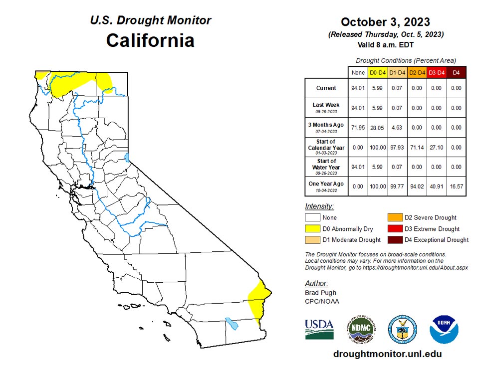
California and National Drought Summary for October 3, 2023
Summary
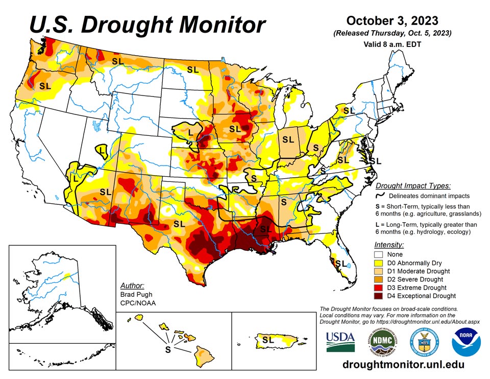
October 5, 2023 - The rapid onset and intensification of drought continued across the South with drought expanding northeast from the Lower Mississippi Valley to the Tennessee Valley and Southern Appalachians. A drier-than-normal September led to an expansion of abnormal dryness (D0) and moderate short-term drought (D1) across the Upper Ohio Valley, Eastern Corn Belt, and western parts of Pennsylvania, New York, and West Virginia. Drought of varying intensity persists across the Middle to Upper Mississippi Valley and parts of the Great Plains. However, heavy rainfall at the beginning of October resulted in improvement for the Southern High Plains. A suppressed 2023 Monsoon led to intensifying drought across Arizona and western New Mexico. Early fall precipitation began to ease drought along the coastal Pacific Northwest. Drought continues to worsen along the leeward side of Maui.
Northeast
A drier-than-normal September (precipitation deficits of 2 to 4 inches) resulted in an expansion of abnormal dryness (D0) and moderate short-term drought (D1) across western parts of Pennsylvania, New York, and West Virginia. Severe drought (D2) was added to western New York, based on 60-day SPI and 28-day average streamflows below the 10th percentile. Despite near to above-average precipitation last month, longer-term precipitation deficits support a continuation of D0 and D1 across parts of southern Pennsylvania, Maryland, and eastern West Virginia.
Southeast
A broad 1-category degradation was necessary for much of Alabama, Georgia, and the western Carolinas. The drought expansion and intensification was based on 30 to 60-day SPI/SPEI, NDMC’s short-term blend, and soil moisture. The largest 30-day precipitation deficits (3 to 5 inches) are centered across the Southern Appalachians. This recent dryness is even leading to much lower 28-day average streamflows. Severe drought (D2) was introduced to the southwest corner of Georgia and expanded across the Florida Panhandle, supported by soil moisture and NDMC’s short-term blend. Heavy rainfall prompted a removal of abnormal dryness (D0) along coastal northeastern Florida, while D0 expanded across the interior areas of northeastern Florida. There was a slight northward expansion of D0 and moderate drought (D1) in Hillsborough and Pasco counties of Florida.
South
A broad 1-category degradation was made to the Lower Mississippi Valley and Tennessee Valley as 30-60 day SPI/SPEI, NDMC short-term blend, soil moisture, and impacts supported expanding/intensifying drought. Impacts in Mississippi include poor pasture conditions, soybean and peanut losses, and cattle sell offs. Severe (D2) to exceptional (D4) drought persists across much of Mississippi and Louisiana, while drought of varying intensity affects the Southern Great Plains. Heavy rainfall (more than 2 inches) on October 2nd supported a 1-category improvement across the Oklahoma Panhandle and western Texas. Based on state recommendations and consistent with the NDMC drought blends, the extreme drought (D3) was slightly reduced across western Texas.
Midwest
A mix of degradations and improvements were made this past week across the Middle to Upper Mississippi Valley, Ohio Valley, and Corn Belt. The largest areas of degradation were focused across Indiana and Ohio where many areas have received less than 25 percent of their normal precipitation during the past 30 days and soil moisture indicators continue to decline. Based on NDMC’s short to long-term blends and soil moisture, extreme (D3) and exceptional (D4) drought was expanded across eastern Iowa. Parts of Kentucky, southern Illinois, Minnesota, and Wisconsin had a 1-category improvement after heavy rainfall (more than 1.5 inches) the previous week.
High Plains
Increasing 30 to 60-day deficits along with support from SPIs at various time scales and the NDMC’s short-term drought blend, a 1-category degradation was made to northeastern Kansas and southeastern Nebraska. Despite a mostly dry week across southern South Dakota, a reassessment of current indicators such as NDMC’s drought blends supported a decrease in abnormal dryness (D0) and moderate drought (D1) in that area. A 1-category degradation was made to northwestern Colorado, based on SPEIs at multiple time scales along with support from soil moisture and vegetation indicators.
West
Following the drier-than-normal Monsoon, a 1-category degradation was warranted for parts of Arizona and western New Mexico. Conversely, heavy rainfall (more than 2 inches) on October 2nd led to a 1-category improvement for parts of eastern New Mexico. NDMC’s short-term blend and soil moisture supported a 1-category degradation in eastern Utah. Extreme drought (D3) was improved to severe drought (D2) in parts of northern Montana based on indicators dating back 12 months. In addition, 28-day average streamflows are above the 5th percentile in northwestern Montana. During the past two weeks, coastal Oregon and the Puget Sound of Washington received 3 to 6 inches of precipitation which supported a 1-category improvement.
Caribbean
No changes were made to Puerto Rico and will be reassessed next week after the passage of Tropical Storm Philippe.
No changes were made to ongoing drought conditions in the U.S. Virgin Islands this week; any rain associated with Tropical Storm Philippe that fell after 8 a.m. Tuesday will be considered in next week’s analysis. Rainfall amounts on St. John ranged from 0.47 inches to 0.65 inches to 0.81 inches. Given decreasing groundwater levels and rainfall amounts that do not do much to move the needle, short- and long-term severe drought continued. Some recovery in groundwater levels occurred this week after rainfall amounts exceeded 1.8 inches at a couple of measuring sites on St. Thomas. However, long-term precipitation deficits remained large enough that exceptional short- and long-term drought continued. Exceptional short- and long-term drought also continued on St. Croix, where a few locations received just over 0.9 inches of rain this week.
Pacific
No changes were made this week with a D0 (abnormal dryness) area remaining across the northeast Interior.
During late September, rainfall associated with the trade winds resulted in improving conditions along the Koolau Range on Oahu and northeast-facing slopes of Maui. Conversely, extreme drought (D3) was added to the leeward sides of Maui and parts of the Big Island. These D3 additions were consistent with NDVI data and reports of poor grazing conditions.
Weather in American Samoa turned wetter this week, with rainfall totals of 1.48 inches at Pago Pago, 1.95 inches at Toa Ridge, and 3.75 inches at Siufaga Ridge. Short-term moderate drought continued, though conditions have likely improved a bit since last week.
Rainfall amounted to 1.06 inches at the Palau airport and 3.04 at Koror, and conditions remained free of drought or abnormal dryness.
The Mariana Islands remained free of drought or abnormal dryness this week. Reports from the CoCoRaHs network on Guam ranged from 1.8 inches of rain on the low end to 3.66 inches on the upper end. Saipan reported 2.4 inches of rain this week, and rain totaled 3.94 inches at the observing site on Rota.
The Federated States of Micronesia remained free of drought or abnormal dryness this week. Yap recorded 1.83 inches of rain, and Ulithi received 2.72 inches. Woleai and Fananu reported 1.56 and 2.75 inches of rain, respectively. This week was a little drier than previous weeks on Chuuk, with only 0.59 inches, following over 5 inches last week. Lukunor reported 3.84 inches of rain, while Nukuoro reported 2.35 inches, continuing recent wetter weather in both locations. Kapingamarangi received 2.4 inches of rain this week, and Pohnpei received 2.53 inches. Kosrae reported 3.54 inches of rain, while Pingelap was a little drier, coming in with 1.27 inches of rain.
Short-term abnormal dryness continued on Kwajalein, though with 3.7 inches having fallen this week, conditions have likely improved some after recent drier weeks. Recent drier weather continued on Ailinglapalap this week with 1.44 inches of rain, marking the fourth consecutive week with less than 2 inches of rain, and short-term abnormal dryness continued there. Following a couple wetter weeks, only 0.51 inches of rain fell this week on Jaluit. However, conditions remained free of drought or abnormal dryness. Wotje reported 0.67 inches of rain, continuing a recent stretch of dry weather, and short-term abnormal dryness continued. While 1.85 inches of rain fell this week on Majuro, this marked the fifth consecutive week with less than 2 inches of rain, which led to near-record dryness for September. Therefore, Majuro was degraded to short-term abnormal dryness. Mili recorded 2.7 inches of rain and remained free of drought or abnormal dryness. No data were reported for Utirik, so no depiction was made there.
Looking Ahead
During the next five days (October 5-9, 2023), a strong cold front is forecast to progress across the central and eastern U.S. with precipitation amounts of an inch or less across the Ohio Valley with heavier amounts (locally more than 2 inches) for southeastern Oklahoma and eastern Texas. The remnants of Tropical Storm Philippe may become entrained within this eastward-advancing cold front and bring heavy rain and flooding to New England on October 7 and 8. Mostly dry weather is forecast throughout the Southeast. By the second week of October, enhanced onshore flow with associated periods of precipitation are forecast to return to the Pacific Northwest. A major temperature pattern change is likely during this 5-day period as cooler-than-normal temperatures overspread the central and eastern U.S.
The Climate Prediction Center’s 6-10 day outlook (valid October 10-14, 2023) favors above-normal precipitation along the Gulf and East Coasts. Increased probabilities for above-normal precipitation are also forecast for the Pacific Northwest and Northern Rockies. Below-normal precipitation is most likely across the Central to Southern Great Plains and Southwest. Below-normal temperatures are favored for most of the Northeast, while above-normal temperature probabilities are enhanced from the West Coast to the Mississippi Valley.
Author(s):
Brad Pugh, NOAA/CPC
Curtis Riganti, National Drought Mitigation Center
Dryness Categories
D0 Abnormally Dry—used for areas showing dryness but not yet in drought, or for areas recovering from drought.
Drought Intensity Categories
D1 Moderate Drought
D2 Severe Drought
D3 Extreme Drought
D4 Exceptional Drought
Drought or Dryness Types
S Short-term, typically less than 6 months (agriculture, grasslands)
L Long-term, typically more than 6 months (hydrology, ecology)
SL Area contains both short- and long-term impacts
Source: National Drought Mitigation Center
