


California and National Drought Summary for October 20, 2015
Summary
Dry weather dominated much of the country, favoring summer crop harvesting and winter wheat planting. However, topsoil moisture shortages hampered wheat emergence and establishment in a variety of regions, including portions of the Plains, lower Midwest, and interior Northwest. Meanwhile, significant short-term drought continued to grip the South, primarily from the southeastern Great Plains to the Mississippi Delta. In addition to concerns about recently planted winter wheat, Southern drought issues included stress on pastures and late-maturing summer crops; an elevated risk of wildfires; and diminishing surface-water supplies. In stark contrast, dry weather in South Carolina and environs favored flood-recovery efforts. Starting on October 16-17, widespread freezes ended the Midwestern growing season—as much as 1 to 2 weeks later than the normal first freeze in some locations. On October 18-19, freezes into the mid-Atlantic region and interior Southeast were roughly on schedule, or even a little earlier than normal. Elsewhere, a period of record-setting Western warmth preceded the arrival of a slow-moving storm system. Showers overspread California by October 15 and over the next several days reached into the Great Basin, Southwest, and Intermountain West. The Western precipitation caused local flooding, but replenished topsoil moisture, benefited rangeland and pastures, and provided limited relief from long-term drought. Significant rain began to overspread the south-central U.S. on October 21, a day after the drought-monitoring period ended, and will be reflected in next week’s U.S. Drought Monitor.Great Plains
Mostly minor expansion of abnormal dryness (D0) and moderate drought (D1) was noted across the northern and central Plains. Conditions were not as dry as those being experienced farther south, but some impact on winter grain emergence has been reported. In Colorado, most (95%) of the winter wheat had been planted by October 18, but emergence (60%) lagged the 5-year average by 12 percentage points. On the same date, topsoil moisture was 59% very short to short in Kansas and 50% very short to short in Colorado.Hawaii, Alaska and Puerto Rico
Neither drought nor dryness is currently being depicted in Hawaii. In Alaska, ongoing wetness in southern Alaska led to further reduction of abnormal dryness (D0) on the Kenai Peninsula and environs. Anchorage recently completed its wettest September on record, with a monthly total of 7.71 inches, and received another 1.73 inches during the first 20 days of October. Meanwhile, heavy showers in northeastern Puerto Rico led to a small area of reduction in drought intensity (from severe to moderate drought, or D2 to D1). There was also a slight reduction in the coverage of abnormal dryness (D0) in north-central Puerto Rico. The remainder of Puerto Rico’s drought depiction remained unchanged. In San Juan, the tenth-longest string of consecutive 90-degree readings, which lasted from September 24 to October 14, ended at 21 days.Mid-South and Environs
A sharp, 3- to 4-month drought has brought significant impacts to a broad area stretching from southern Oklahoma and central and eastern Texas to the Mississippi Delta. In mid-October, a spell of extreme heat—accompanied by gusty winds and low humidity—caused further drought intensification and brought a rash of fires. Little Rock, Arkansas, experienced its hottest October day on record (98°F on October 15). Other all-time October records set in Arkansas on the 15th included 97°F in Monticello and Stuttgart. In Louisiana, Shreveport (98°F on October 15) just missed its monthly record high of 99°F, set on October 1, 1938. With a high of 93°F on October 15, Memphis, Tennessee, reported its latest reading above the 90-degree mark (previously, 92°F on October 14, 1963).Due to the drought, a variety of burn bans are in effect. In Mississippi, the state forestry commission has reportedly responded to more than 430 wildfires since October 1. A number of fires have burned in areas that are typically marshy or swampy. Near Sabine Pass, Texas, a wildfire charred approximately 5,000 acres of tall grass. And east of Bastrop, Texas, the Hidden Pines fire—which started on October 13—has consumed more than 4,500 acres of mostly forested land and destroyed 64 homes.
By October 18, USDA reported topsoil moisture 89% very short to short in Arkansas, along with 85% in Louisiana, and 83% in Mississippi. On the same date, pastures rated very poor included 49% in Arkansas, 46% in Louisiana and Texas, and 43% in Mississippi. Some producers were opting to await rain before planting winter wheat; in Arkansas, for example, wheat was 22% planted by October 18, compared to the 5-year average of 27%.
Midwestern and Great Lakes States
Mostly dry weather supported a rapid expansion of abnormal dryness (D0) and moderate drought (D1), especially from Missouri to Michigan and Ohio, and across the upper Midwest. By October 18, topsoil moisture—as rated by the U.S. Department of Agriculture—stood at 68% very short to short in Missouri, along with 53% in Indiana, 52% in Illinois, and 46% in Ohio. Sub-state readings indicated more significant dryness in several areas. Among them was the western division of Illinois—bordered by southeastern Iowa and northeastern Missouri—which reported topsoil moisture 86% very short to short, and the east-central division of Missouri (91% very short to short). Although the short-term Midwestern dryness remained favorable for fieldwork, recently planted winter wheat was in need of rain to ensure even emergence and proper crop establishment.Southeast
Although much of the region remained free of drought, there was a slight expansion of abnormal dryness (D0) and moderate drought (D1) in central and southern Georgia. Through October 20, year-to-date rainfall in Macon, Georgia, totaled 30.20 inches (81% of normal). In contrast, D0 was trimmed slightly in southern Florida, supported by ongoing showers and an assessment of the 2015 wet season.The Northeast
Scattered rain and snow showers in the vicinity of Lakes Erie and Ontario prevented significant expansion of abnormal dryness (D0). Closer to the Atlantic Coast, dry weather kept moderate drought (D1) intact from northern New Jersey to southern Maine. Through October 20, year-to-date precipitation totaled 27.26 inches (79% of normal) in Boston, Massachusetts, and 27.76 inches (80%) in Bridgeport, Connecticut.West
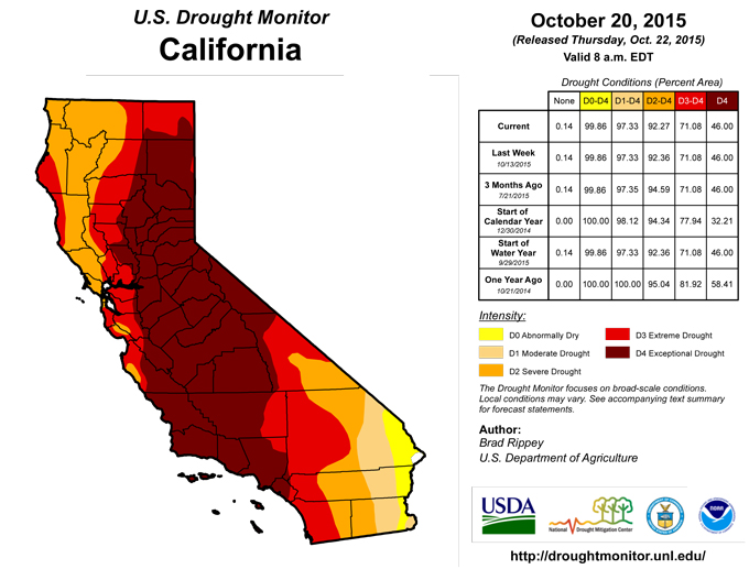
Precipitation began to overspread central and southern California on October 15 and eventually reached into many other areas of the western U.S. However, extremely dry conditions persisted in much of Oregon and Washington, hampering winter crop establishment. By October 18, winter wheat emergence was at least 10 percentage points behind the 5-year average pace in Oregon (18% emerged) and Washington (62%). California led the nation with both topsoil and subsoil moisture rated 90% very short to short. Approximately two-thirds of the rangeland and pastures were rated very poor to poor in Oregon (67%) and California (65%). Finally, significant water-supply shortages—owing to the multi-year drought—were noted in Arizona, California, Nevada, and New Mexico. In the Northwest, statewide reservoir storage was also below average in Oregon, and Washington. On September 30, California’s statewide reservoir storage was 54% of the historical average for this time of year—and the second-lowest on record behind 1977.During the drought-monitoring period, precipitation became heavy enough to result in some very minor improvements in the long-term drought depiction, primarily in Arizona and Nevada. Further refinements may be needed next week as assessments continue, especially since the storm was still in progress on October 20.
Looking Ahead
During the next 5 days, a slow-moving storm system will provide significant drought relief but possibly cause flash flooding in the south-central U.S. Five-day rainfall totals could reach at least 2 to 5 inches on the southern High Plains; 2 to 6 inches in the western Gulf Coast region; and 3 to 7 inches across the southeastern Plains. Showers will also overspread the northern and central Plains, although totals from Nebraska to the Dakotas will be mostly an inch or less. Scattered showers will also reach the Ohio Valley and the Midwest, but mostly dry weather will prevail through the weekend in the southern Atlantic States and the Far West. Outside of the storm system’s primary impact area (e.g. the south-central U.S.), warm weather will prevail nearly nationwide.The NWS 6- to 10-day outlook for October 27 – 31 calls for the likelihood of warmer-than-normal weather across Florida, Alaska, and from the Pacific Coast to the northern and central Plains and the upper Midwest. Meanwhile, near- to below-normal temperatures can be expected across much of the South, East, and lower Midwest. The last 5 days of October should feature near- to above-normal precipitation across the majority of the U.S., with the greatest likelihood of wet weather occurring across the lower Southeast. In contrast, drier-than-normal conditions should occur in western Alaska and from the northern Plains into the upper Great Lakes region.
Author(s):
Brad Rippey, U.S. Department of Agriculture
Dryness Categories
D0 ... Abnormally Dry ... used for areas showing dryness but not yet in drought, or for areas recovering from drought.Drought Intensity Categories
D1 ... Moderate DroughtD2 ... Severe Drought
D3 ... Extreme Drought
D4 ... Exceptional Drought
Drought or Dryness Types
S ... Short-Term, typically <6 months (e.g. agricultural, grasslands)L ... Long-Term, typically >6 months (e.g. hydrology, ecology)
Source: National Drought Mitigation Center
