


California and National Drought Summary for October 17, 2023
Summary
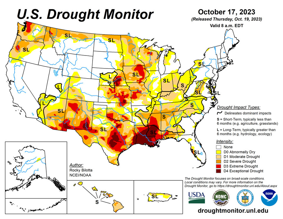
October 19, 2023 - An intense low-pressure system moved across the contiguous U.S., bringing heavy precipitation (greater than 2 inches) across much of the central Plains and Midwest this week. While in the southeast, upper-level energy moving across the Southeast brought rain over parts of Alabama, Georgia, South Carolina, and northern Florida, before moving into the southern Mid-Atlantic. The most widespread improvements were made to northern Nebraska, eastern South Dakota, southern Minnesota, southern Wisconsin, northern Indiana and southern Texas where more well above normal precipitation was observed this past week. Dry conditions continued across much of the Southern region, with widespread degradations occurring across the Tennessee Valley, central Mississippi Valley and northern parts of the southern Plains. Following a wet September, minor improvements were warranted for parts of Washington. In Hawaii, drought continues to intensify across parts of Kauai and the Big Island.
Northeast
Above-normal precipitation fell across southern portions of the region resulting in slight improvements to D0 (abnormal dryness) and D1 (moderate drought) in Maryland and West Virginia. Much of New York and New England remained dry this week, resulting in the expansion of abnormal dryness and moderate drought in western New York. No changes were made to New England.
Southeast
More than an inch of precipitation fell across much of the region this week, with heavy precipitation from central Alabama to central South Carolina, as well as northern Florida. Moderate drought was removed from the Big Bend region in Florida, while abnormal dryness (D0) was removed from parts of central and southern Georgia and eastern North Carolina. Conversely, dryness continues in parts of northern Virginia and northern Alabama, resulting in the expansion of abnormal dryness (D0) to severe drought (D2) across these areas. Moderate drought (D1) was expanded in eastern and western parts of Virginia and western North Carolina. Precipitation was also sparse along parts of the Carolina coast, resulting in the expansion of D0. The drought expansion and intensification was based on short-term SPI/SPEI, NDMC’s short-term blend, streamflow and soil moisture data.
South
Dry conditions continue across much of the Southern region. Exceptional drought (D4) and extreme drought (D3) was expanded in central and northern Mississippi, while D3 was expanded into northern Louisiana. Moderate drought (D1) to severe drought (D2) was expanded in southern Arkansas. Board 1-category degradation occurred over the states of Oklahoma and Tennessee, in addition to parts of western, central and northern Texas, where dryness continues to degrade conditions. Precipitation in these areas are around 1-2 inches below normal for the month. The drought expansion and intensification was based on short-term SPI/SPEI, NDMC’s short-term blend, streamflow and soil moisture data. While heavy precipitation brought improvements to parts of southern and eastern Texas and in southern Mississippi, with some areas reporting over 2 inches of rainfall this week, resulting in exceptional drought being removed from southern Mississippi and extreme drought was removed from southern Texas.
Midwest
A broad 1-category improvement was made to southern Minnesota, southern Wisconsin, northern Illinois and northern Indiana and in parts of Iowa and Ohio where more than an inch of precipitation occurred this past week, with some areas receiving more than 5 inches of precipitation. This excess precipitation, in these areas, alleviated longer-term precipitation deficits and improved soil moisture and streamflow impacts, resulting in improvements to abnormal dryness (D0) and all drought categories. Exceptional drought (D4) was from the region, located in eastern Iowa, and extreme drought (D3) from parts of central and southwest Minnesota. Meanwhile, dry conditions continue to affect the northern and southern parts of the region. Parts of northeastern Wisconsin continues to be dry, resulting in the expansion of moderate drought (D1) and severe drought (D2), while D0 and D1 was expanded into parts of northwest and southeast Missouri, and D0 and D1 was expanded into parts western, central and eastern Kentucky. Degradations were supported by precipitation deficits, short-term SPI/SPEI timescales, streamflow and soil moisture data.
High Plains
Heavy precipitation brought widespread improvements to the southeastern parts of the region, especially along the South Dakota and Nebraska border. Much of northern Nebraska received at least 2 inches of precipitation, with some areas reporting more than 7 inches this week. Board 1-category improvements were made across northern Nebraska, while 2-category improvements were made where historic rainfall was reported. The heavy precipitation also improved abnormal dryness (D0) and moderate to severe drought (D1-D2) conditions in eastern South Dakota, as shown in short-term SPI/SPEI timescales and soil moisture data. A small area in southwest Nebraska, Chase County, was degraded to D1 due to acute dryness over the past two months and justified by short-term SPI/SPEI data and soil moisture being consistently under the 20th percentile. In Kansas, northern parts of the state received precipitation this past week but not enough to lead to large improvements. Precipitation did improve a small area of extreme drought (D3) in the central part of the state, in the counties of McPherson and Saline. Status quo was maintained across much of the state with some degradation occurring along the eastern part of the state based on SPI/SPEI and soil moisture data.
West
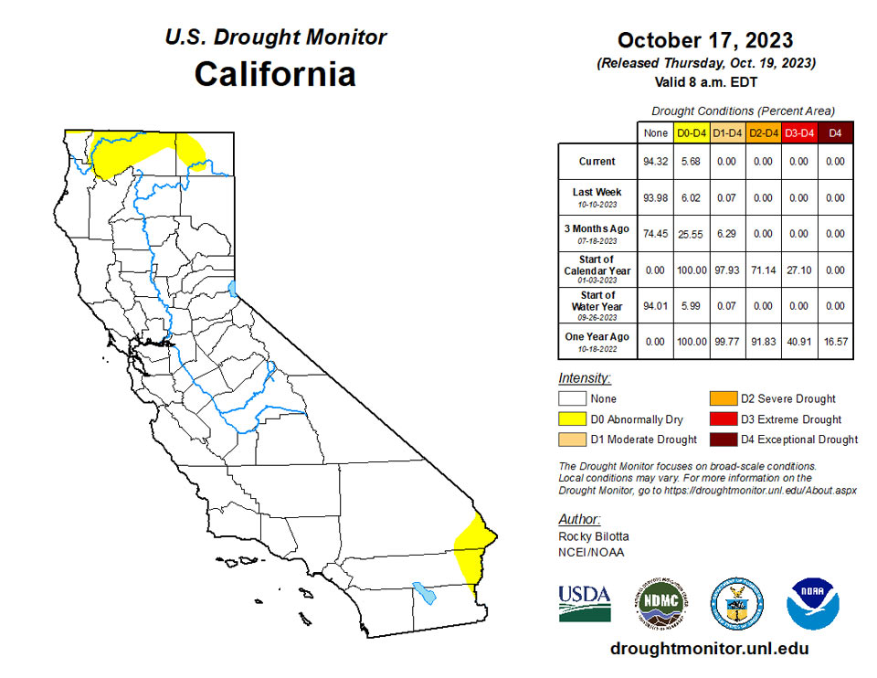
Precipitation fell across much of the West with heavy precipitation along the coast from Washington to northern California, where more than 1 inch of precipitation occurred this past week. Above-normal precipitation led to improvements to severe drought (D2) in southwest Washington, along with abnormal dryness (D0) to extreme drought (D1-D3) improvements to western Oregon and D0 to moderate drought (D1) improvements in northern California. Beneficial precipitation led to improvements in moderate drought to extreme drought (D0-D3) in portions of northwest Montana, as shown in SPI/SPEI, streamflow and soil moisture data. Status quo was maintained across the rest of the region this week.
Caribbean
Precipitation fell over parts of Puerto Rico this week but not enough to make improvements to moderate drought (D1) or abnormal dryness (D0) on the island.
With little to no rain, drought conditions persisted across the US Virgin Islands.
Rainfall totals varied this week across St. Croix. While the Henry Rohlsen Airport had no rain, most CoCoRaHs stations across the island had less than 1 inch of rain, with the exception of two locations that had a little over 1 inch. The month-to-date rainfall total at the airport was 214.3% of normal (5.10 inches) and year-to-date total was 70.2% of normal. Last week's rainfall helped increase the groundwater levels; however, they were still ~33 ft below land surface. SPI values at the 3, 6, 9, and 12 were indicative of moderate to exceptional drought, while the 1-month was indicative of drought free conditions. For this week, short- and long-term extreme drought persisted across St. Croix.
In St. Thomas, the Cyril E King Airport had close to 1 inch of rain this week, resulting in a month-to-date total of 186.3% of normal rain (5.05 inches). The year-to-date total at the airport is 61.5% of normal. CoCoRaHs stations had a weekly total of less than 1 inch. SPI values at the 3, 6, 9, and 12 months are indicative of abnormally dry conditions to extreme drought, while drought free conditions were indicative at the 1-month. For this week, short- and long-term extreme drought continued.
Long-term abnormally dry conditions continued across St. John since it had little to no rain this week. The Windswept Beach location had no rain, resulting in a month-to-date total of 9.41 inches. This is 306.9% of normal rain and 95.3% of normal for the year-to-date. SPI values at the 1, 3, 6, and 9 months were indicative of drought free conditions, while at the 12-month were indicative of abnormally dry conditions.
Pacific
No changes were made this week to the abnormal dryness (D0) area on the western Yukon Flats.
Dry conditions continue across the islands of Hawaii this week. The lower leeward slopes of Kauai remain dry, resulting in expansion of severe drought on the island. On the Big Island, severe (D3) drought was introduced in the north central portion of the island, while existing D3 drought was expanded near South Point towards the northeast.
Airai had 0.67 inch of rain this week. Despite having a dry week, drought free conditions persisted since the previous week this same location had over 6 inches of rain.
Drought was not a concern across the Mariana Islands since all three locations had over 3 inches of rain for the week and over 7 inches for the month.
Most of the Federated States of Micronesia continued to be free of drought since most locations received close to or over their weekly threshold of 2 inches.
Lukunor, Pingelap, and Woleai had less than an inch of rain this week; however, drought free conditions continued since the previous week these locations had very wet conditions.
It was a dry week for most locations across the Marshall Islands. Several locations had less than 1 inch of rain for the week. Despite the dry conditions this week, Ailinglaplap, Jaluit, and Mili continued to be drought free since they had very wet conditions last week. Meanwhile, Kwajalein and Wotje continued to be abnormally dry since they had little to no rain this week. Majuro was the only location to have over 2 inches of rain at 3.70 inches.
This was a wet week for Tutuila, with all three locations receiving over 1 inch of rain. Suifaga Ridge had the most rain with over 5 inches of rain. Since all three locations surpassed their weekly threshold and the month-to-date totals already surpassed the monthly threshold of 4 inches, Tutuila's drought classification was changed from moderate drought to abnormally dry conditions.
Looking Ahead
During the next five days (October 19-24, 2023), a front extending from the Upper Mississippi Valley to the Southern High Plains will move eastward to the Lower Great Lakes/Mid-Atlantic to the Central Gulf Coast by Friday. The system will produce rain over parts of the Upper/Middle Mississippi Valley on Wednesday evening, moving into the Great Lakes/Ohio Valley by Thursday and continuing eastward into Friday. On October 21, guidance shows potential for significant rainfall over parts of the Northeast, while the West is forecasted to receive rain from the weekend into next week. Some of the precipitation over the West should fall as snow in the higher northern Rockies, with snow levels gradually declining with time.
The Climate Prediction Center’s 6-10 day outlook (valid October 23-27, 2023) favors near to above-normal precipitation throughout much of contiguous U.S., Alaska and Hawaii with below-normal precipitation most likely across the East Coast and in parts of southeast Alaska and on the Big Island in Hawaii. Increased probabilities for above-normal temperatures are forecast from the Plains to the East Coast, as well as much of Alaska and Hawaii, while below-normal temperatures are likely across much of the West.
Author(s):
Rocky Bilotta, NOAA/NCEI
Ahira Sanchez-Lugo, NOAA/NCEI
Dryness Categories
D0 Abnormally Dry—used for areas showing dryness but not yet in drought, or for areas recovering from drought.
Drought Intensity Categories
D1 Moderate Drought
D2 Severe Drought
D3 Extreme Drought
D4 Exceptional Drought
Drought or Dryness Types
S Short-term, typically less than 6 months (agriculture, grasslands)
L Long-term, typically more than 6 months (hydrology, ecology)
SL Area contains both short- and long-term impacts
Source: National Drought Mitigation Center
