


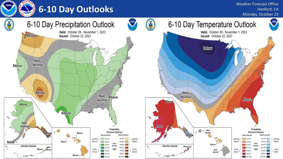
October 23, 2023 - National Weather Service Hanford Office officials report the latest 6-10 Day Temperature Outlook has the San Joaquin Valley at 33 to 40 percent chance of below average temperatures and the Sierra Nevada with a 40 to 50 percent chance of below average temperatures.
The precipitation outlook has a gradient of 33 to 40 percent above average precipitation in the northern portion of the San Joaquin Valley to near normal for a sliver of Kern, Kings and Tulare County before a 33 to 40 percent chance of below normal precipitation for the Kern County Desert.
Area Forecast Discussion
National Weather Service Hanford CA
244 AM PDT Mon Oct 23 2023
.SYNOPSIS...
Average temperatures will be present for the San
Joaquin Valley through mid week before an upper level trough
passing through the region brings a cooling trend towards the
weekend. Some moisture ahead of the trough will result in partly
cloudy conditions and a slight chance for precipitation in the
Sierra Nevada.
&&
.DISCUSSION...
An upper level trough will continue to track south
along the length of California today. Moisture around the center
of the upper low will bring cloudy conditions to the Central
Valley for much of the day, clearing into the late
afternoon/evening. There is a slight chance for precipitation in
the southern portions the forecast region this morning, continuing
from the overnight period. The trough is expected to bring a
slight cooldown to the region, with maximum afternoon temperatures
in the mid to upper 70s. These temperatures are near average for
this time of year. As the trough moves out of the region to the
south, model guidance suggests a weak upper level ridge will enter
the region, keeping conditions relatively consistent through
Wednesday.
Towards the latter portions of this week, forecast ensembles
are indicating another upper level trough will drop into the
region from the Pacific northwest. Ahead of the trough, some
moisture may enter the forecast area from the west and bring
slightly cloudier conditions with a chance for precipitation in the
Sierra Nevada. As the upper low moves through, northerly flow
will bring cooler, drier air to Central California from the polar
regions. There is good potential for a stronger cooldown
associated with this system than earlier in the week. Maximum
afternoon temperatures for Thursday and Friday are expected to
hover near 70 degrees, around 5 degrees below normal. Even cooler
conditions are anticipated for the weekend, with forecast models
indicating afternoon temperatures in the mid 60s, 8 to 10 degrees
below average. Additionally, probabilistic guidance expresses a
70-80% chance for maximums to remain below 70 degrees. The drier
conditions aloft associated with the upper level disturbance will
result in clearing skies later this week.
&&
AVIATION...
Scattered, light showers this morning in the southern San Joaquin
Valley. Otherwise, VFR conditions will continue to prevail for
the next 24 hours.
&&
.AIR QUALITY ISSUES...
ISSUED: 10/22/2023 12:54
EXPIRES: 10/23/2023 23:59
None.
&&
.CERTAINTY...
The level of certainty for days 1 and 2 is high.
The level of certainty for days 3 through 7 is medium.
Certainty levels include low...medium...and high. Please visit
www.weather.gov/hnx/certainty.html for additional information
and/or to provide feedback.
&&
.HNX WATCHES/WARNINGS/ADVISORIES...
Wind Advisory until 8 AM PDT Monday for CAZ338
Source: NWS
