


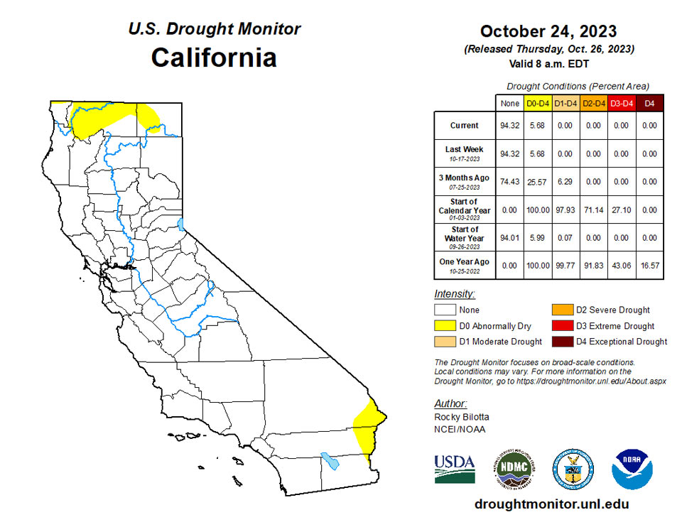
California andNational Drought Summary for October 24, 2023
Summary
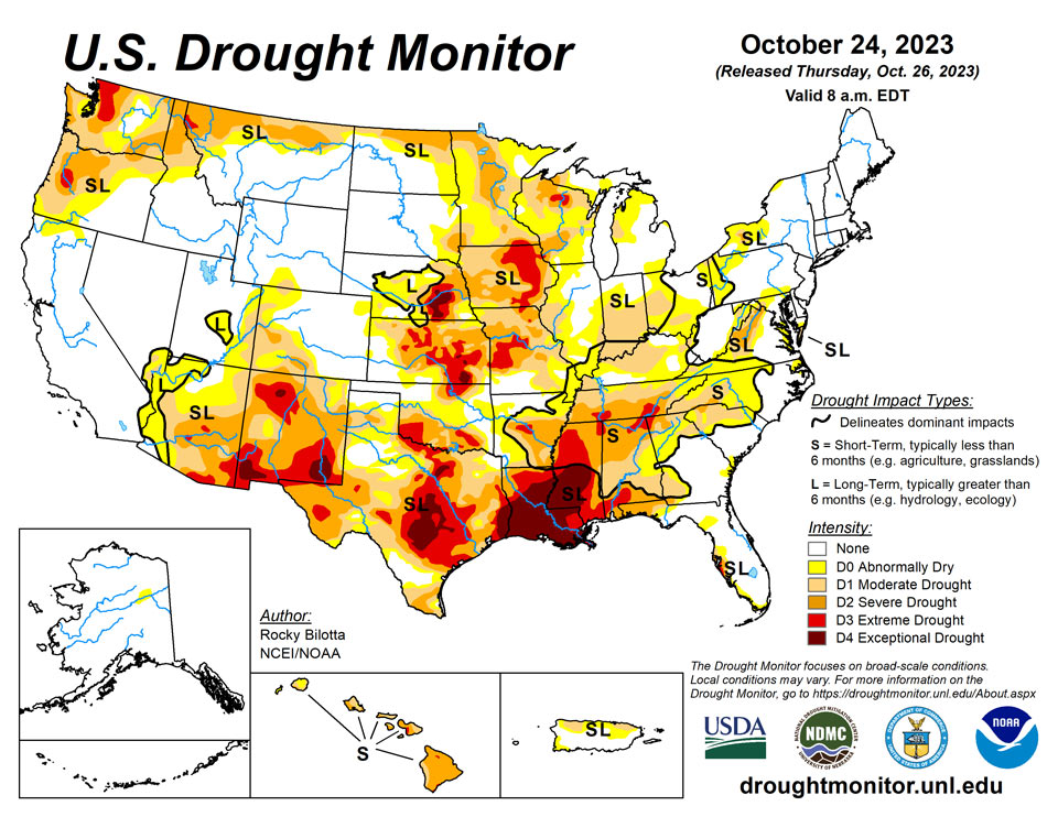
October 26, 2023 - A strong upper-level ridge dominated much of the western U.S., providing anomalously warm temperatures, by as much as 20 degrees above average, and dry conditions over the central and western parts of the country. While a front extending from the Great Lakes to the Gulf Coast produced rain over parts of Ohio Valley and Great Lakes before moving eastward and bringing rain to parts of the Northeast and Southeast. The most widespread improvements were made to parts of eastern Texas, central Wisconsin and in parts of the Ohio River Valley, where above-normal precipitation was observed this past week. Dry conditions continued across much of the Southern region, with widespread degradations occurring across the Tennessee Valley, central Mississippi Valley and northern parts of the Southeast. In the Southwest, near- to record-warm temperatures coupled with below-normal precipitation for the month, resulted in degradation in the southern parts of the region. In Hawaii, drought continues to intensify across all islands, while no changes occurred on Kauai.
Northeast
Above-normal precipitation fell across much of New England and in southern portions of the region, resulting in improvements to abnormal dryness (D0) and moderate drought(D1) in West Virginia. Much of New York remained dry this week, justifying the expansion of D0 and D1 in western New York where precipitation is less than 25% of normal for the week.
Southeast
Precipitation fell across much of the region this week but rainfall amounts were well below normal, resulting in another week of 1-category degradations across parts of Alabama, Georgia and the Carolinas. The drought expansion and intensification was based on short-term SPI/SPEI, NDMC’s short-term blend, streamflow and soil moisture data. Based on these short-term indicators, extreme drought (D3) was expanded in southern Alabama and introduced in parts of northern Alabama and Georgia where precipitation amounts for the last 7 days were less than 5% of normal and range between 2-4 inches below normal for the month. Moderate drought (D2) was expanded in parts of Alabama and Georgia, while D2 was introduced in parts of western North Carolina and southwest South Carolina this week. Moderate drought (D1) was expanded in Georgia, eastern Alabama, northern South Carolina and western North Carolina, while abnormal dryness (D0) was expanded in small parts of eastern Alabama and northern South Carolina.
South
Dry conditions continued across much of the Southern region this week while heavy precipitation fell over parts of eastern Texas to southern Oklahoma. Portions of the Texas Panhandle received up to 4 inches of rainfall (up to 600% above normal) this week, resulting in removal of exceptional drought (D4) while extreme drought (D3) and severe drought (D2) conditions were improved in this region. On the dry side, a broad 1-category degradation was made to Arkansas, Tennessee and in northern parts of Mississippi and Louisiana, where little to no precipitation fell. Extreme drought was expanded in southeast Louisiana, while D3 was expanded in northern Louisiana, northern Mississippi and introduced in parts of central Arkansas and southern Tennessee. Precipitation in these areas are around 2-3 inches below normal for the month. The drought expansion and intensification was based on short-term SPI/SPEI, NDMC’s short-term blend, streamflow and soil moisture data.
Midwest
A broad 1-category improvement was made across much of the northern Ohio Valley, central Wisconsin and western Minnesota, where 0.5 to 3 inches of rainfall (up to 400% of normal) occurred this past week. Above-normal precipitation helped to alleviate longer-term precipitation deficits and improved soil moisture and streamflow impacts, resulting in improvements to abnormal dryness (D0) and all drought categories. Severe drought (D2) improved in southern Minnesota and northeast Wisconsin, while moderate drought (D1) was improved in southern Minnesota, central Wisconsin, western Kentucky and Ohio. Meanwhile, dry conditions continue to affect southern parts of the region, where precipitation is as low as 5% of normal for the week. D0 to D2 was expanded across parts of Missouri, while D1 was expanded into southern Illinois and eastern Kentucky. Degradations were supported by precipitation deficits, short-term SPI/SPEI timescales, streamflow and soil moisture data.
High Plains
Precipitation fell over the northern and eastern parts of the region, with much of the rain falling outside of the drought areas. For this reason, much of the High Plains remained as status quo this week. Little to no precipitation fell over most of Nebraska, Kansas, Colorado and southern Wyoming. This coupled with above-normal temperatures (around 10-15°F above normal), along with deteriorating conditions shown in short-term SPI/SPEI, streamflow and soil moisture data, justified slight degradations across these states. Severe drought (D2) was expanded in northeast Kansas, while moderate drought (D1) was expanded in the southeast part of the state. D1 was also expanded in parts of southwest Wyoming, while abnormal dryness (D0) was expanded from southwest Nebraska into northeast Wyoming and D0 was introduced along the central border of Kansas and Wyoming.
West
Much of the West remained as status quo this week. Precipitation fell across much of the region, which was enough to prevent further degradation but not enough to warrant large improvements. Heavier precipitation fell across parts of Montana, with rain totals up to 300-400% above normal, over the past week. This beneficial rainfall, along with precipitation percentiles and short-term SPI/SPEI, soil moisture and streamflow data, resulted in abnormal dryness (D0) and moderate (D1) to severe (D2) drought improvements along the northern parts of Montana. As for temperature, much of the region was well above normal with temperatures up to 15°F above normal. Parts of the Southwest are experiencing record warm temperatures for this month-to-date period, while Phoenix, AZ, reached 105°F on October 16th and 104°F on October 19th and 20th, setting the three hottest temperatures on record for this time of the year. These above-normal temperatures coupled with below-normal precipitation resulted in the expansion of D1 and D2 in southern Arizona and across the state of New Mexico. Introduction of D3 was also added to northwest New Mexico based on precipitation deficits and short-term SPI/SPEI and soil moisture data.
Caribbean
Hurricane Tammy brought swells and precipitation to parts of Puerto Rico, slightly improving abnormal dryness (D0) on the eastern part of the island.
Hurricane Tammy brought some beneficial rains to parts of the US Virgin Islands (USVI) this drought week; however, drought continued to persist in the region.
In St. John, the Windswept Beach had the most rain this week with 1.48 inches, resulting in a month-to-date (MTD) rainfall total of 10.89 inches (247.1% of normal) and a year-to-date (YTD) rainfall total of 95.9% of normal. Since SPI values were indicative of drought free conditions at the 1,3,6, and 9 months; however, abnormally dry conditions remained at the 12-month period. If conditions continue to improve next week, a 1-category improvement might be considered for St. John.
In St. Thomas, while the CoCoRaHs stations across St. Thomas had weekly rainfall totals that ranged between half an inch to a little over 1 inch, the Cyril E King Airport had 1.53 inches of rain this week. The month-to-date rainfall total at the airport was 6.58 inches (162.8% of normal) and the year-to-date total at this location was 63.3% of normal. Short- and long-term extreme drought persisted despite the beneficial rain since SPI values were indicative of abnormally dry to exceptional drought at the 1, 3, 6, 9, and 12 -months timescales.
Short- and long-term extreme drought also continued across St. Croix. Rainfall totals varied this week across the island, with most locations having little to no rain. While the Henry Rohlsen Airport had no reported rain, most CoCoRaHs stations across the island had less than 1 inch of rain. The airport's month-to-date rainfall total was 5.10 inches or 152.7% of normal. The year-to-date rainfall total was 67.7% of normal. Groundwater levels were declining steadily, and while the SPI value at the 1-month was indicative of drought free conditions, the 3, 6, 9, and 12-month timescales were indicative of moderate to exceptional drought.
Pacific
No changes were made this week to the abnormal dryness (D0) area on the western Yukon Flats.
Dry conditions continue across much of Hawaii this week, resulting in the expansion of drought on Oahu, Molokai, Lanai, Maui and the Big Island. No changes were made on Kauai this week after pre-frontal rain bands brought some precipitation to parts of the island, but not enough to improve conditions.
Drought was not a concern for Palau and the Mariana Islands this week. Palau had close to 4 inches of rain for the week. While Rota and Saipan (in the Mariana Islands) had less than 1 inch of rain this week, Guam had 1.60 inches of rain. Despite the dry week for Rota and Saipan, drought free conditions persisted across the Mariana Islands. This week marked the first dry week (less than 1 inch of rain) for Rota and Saipan; however, the month-to-date (MTD) rainfall totals for all three locations were over 11 inches, exceeding the monthly threshold of 4 inches to meet most water needs.
This was a dry week for most locations across the Federated States of Micronesia (FSM), with rainfall totals less than 1 inch. Despite the dry conditions, drought was not a concern across the FSM this week since this was only the first or second consecutive dry week and the MTD rainfall totals were close to or over the monthly threshold of 8 inches to meet most water needs.
Across the Marshall Islands, most locations had a wet week (weekly rainfall total equal to or greater than 2 inches). Ailinglaplap, Mili and Wotje had the most rain with rainfall totals above 3 inches. This week marked Wotje's first wet week after several consecutive weeks of dry conditions and its MTD rainfall total was less than the monthly threshold of 8 inches since May. Despite having over 3 inches of rain this week, Wotje's drought classification of abnormally dry conditions persisted. Kwajalein had a little over 2 inches of rain this week, surpassing the weekly threshold of 2 inches to meet most water needs. However, abnormally dry conditions persisted since its MTD rainfall total was less than the monthly threshold of 8 inches. All of the other locations continued to be drought free this week.
Across American Samoa, all three locations had over their weekly threshold of 1 inch, with Siufaga Ridge having close to 4 inches of rain. Since rainfall totals for the weekly and monthly thresholds were surpassed, a 1-category drought improvement was done (from abnormally dry conditions to drought free conditions).
Looking Ahead
During the next five days (October 24-28, 2023), remnant energy and moisture from Tropical Storm Norma could stream northward to spread heavy rainfall to parts of the southern and central U.S. early to mid-next week, while chances of snow increase in the northern Rockies and into parts of the northern Plains late next week. The Weather Prediction Center has highlighted a slight risk of excessive rainfall for parts of northern Texas and west-central Oklahoma due to potential flash flooding. Well above normal temperatures will spread from the Midwest into the East (15-20 degrees above normal), while daytime maximum temperatures for the northern portions of the Rockies and Plains could be 10-20 degrees below normal.
The Climate Prediction Center’s 6-10 day outlook (valid October 28-November 2, 2023) favors near to above-normal precipitation throughout much of contiguous U.S., and Alaska with below-normal precipitation most likely from the Pacific Northwest to the northern Plains, across much of Hawaii and in parts of southeast Alaska. Increased probabilities for below-normal temperatures are forecast for much of the contiguous U.S. while above-normal temperatures are likely from Louisiana to New England, as well as much of Alaska and Hawaii.
Author(s):
Rocky Bilotta, NOAA/NCEI
Ahira Sanchez-Lugo, NOAA/NCEI
Dryness Categories
D0 Abnormally Dry—used for areas showing dryness but not yet in drought, or for areas recovering from drought.
Drought Intensity Categories
D1 Moderate Drought
D2 Severe Drought
D3 Extreme Drought
D4 Exceptional Drought
Drought or Dryness Types
S Short-term, typically less than 6 months (agriculture, grasslands)
L Long-term, typically more than 6 months (hydrology, ecology)
SL Area contains both short- and long-term impacts
Source: National Drought Mitigation Center
