


California and National Drought Summary for October 27, 2015
Summary
A slow-moving storm that had first arrived in California on October 15 drifted eastward across the southwestern and south-central U.S., generating heavy showers. Eventually, the storm lifted northward across the Plains, providing beneficial moisture for emerging winter wheat. However, rain mostly bypassed a few areas, including eastern Kansas and north-central Oklahoma. Farther south, the storm’s trailing cold front became infused with tropical moisture from Patricia, the strongest hurricane on record. (On the morning of October 23, several hours prior to crossing the southwestern coast of Mexico, Patricia’s sustained winds peaked at 200 mph and the central barometric pressure plummeted to 25.96 inches, or 879 millibars. When Patricia made landfall later that day near Cuixmala, Mexico, winds were estimated at 165 mph and the central pressure was 27.17 inches, or 920 millibars.) In part due to the influx of tropical moisture, October 22-25 rainfall topped 20 inches at a few locations in northeastern Texas. Storm-total rainfall reached 5 inches or more in a broader area covering much of eastern Texas, as well as portions of Oklahoma, Arkansas, Louisiana, and Mississippi. Consequently, areas of the South that had received little rainfall in the last 4 months were suddenly deluged by flooding rains. Significant rain began to overspread parts of the Midwest and Southeast on October 27, after the drought-monitoring period ended, and will be reflected in next week’s U.S. Drought Monitor.Great Plains
Widespread rain fell from the southern and central High Plains northward into the Dakotas, hampering fieldwork but providing much-needed moisture for emerging winter grains. On October 25, Oklahoma’s winter wheat was rated 22% very poor to poor, while only 31% of the crop was rated good to excellent. A substantial portion of the wheat was also rated very poor to poor in Texas (20%), Colorado (16%), and Kansas (15%). Although many areas of the Plains received rain that should help to revive pastures and promote winter wheat growth, eastern Kansas and north-central Oklahoma remained dry. In those areas, there was some introduction or expansion of dryness (D0) and moderate drought (D1). In Kansas, statewide topsoil moisture was 52% very short to short by October 25. However, topsoil moisture was at least 70% very short to short in central, north-central, and northeastern Kansas.Hawaii, Alaska and Puerto Rico
There were no changes to the depiction of abnormal dryness (D0) in Alaska, and drought remains at bay in Hawaii—despite a recent drying trend. Meanwhile, heavy, late-October rain in parts of Puerto Rico helped to provide some drought relief. In particular, extreme drought (D3) improved to severe drought (D2) in eastern interior Puerto Rico, as catchment basins began to respond to recent rainfall totals in excess of 5 inches. Slight improvements in the drought depiction were also noted in other parts of eastern Puerto Rico, except along the southern coast, where water rationing is ongoing and aquifer levels have not yet responded.Mid-South, Mississippi Delta, and Texas
A historic rainfall event unfolded from Texas to the Mississippi Delta, greatly easing or completely eradicating short-term drought that had been intensifying during the last 2 to 4 months. The storm system responsible for the drought relief (and flooding) was infused with moisture from record-setting eastern Pacific Hurricane Patricia, which made landfall in southwestern Mexico on October 23. Even after the parent storm system lifted northward across the Plains, a new low-pressure system formed over the northwestern Gulf of Mexico, maintaining the focus for heavy rain through the end of the drought-monitoring period on October 27.Even before tapping into Patricia’s moisture, the parent storm unleashed heavy rain on northwestern Texas. Daily-record amounts for October 21 included 2.38 inches in Borger and 1.38 inches in Dalhart. From October 22-25, Texas rainfall totals reached 11.68 inches in Waco; 7.70 inches in College Station; 7.60 inches in Houston; 7.57 inches in Dallas-Ft. Worth; and 7.55 inches in Tyler and Austin (Bergstrom). Waco experienced its wettest 24-hour period on record, with 9.67 inches of rain falling on October 23-24. Previously, Waco’s wettest 24-hour period had occurred on December 20, 1997, when 7.98 inches fell. Waco also reported its wettest October day (7.75 inches on October 23), eclipsing the record of 5.83 inches set on October 9, 2011. Farther east, Shreveport, LA, received 6.01 inches from October 23-26. Storm-total rainfall exceeded 20 inches at a few locations in northeastern Texas, including Corsicana. From October 23-25, Corsicana was inundated by 21.05 inches of rain, most (16.35 inches) of which fell on the 23rd.
Antecedent dryness prevented large-scale flooding, but downpours resulted in flash flooding and river rises. In Trinidad, Texas, the Trinity River crested 9.45 feet above flood stage on October 25, nearly 7 feet below the level (16.33 feet above flood stage) achieved on June 5, 2015. Farther downstream, the Trinity River near Oakwood, Texas, crested 14.06 feet above flood stage on October 27, a little more than a foot above the level (12.85 feet above flood stage) recorded on May 30, 2015. According to the Texas Water Development Board, statewide reservoirs collectively gained 1.6 million acre-feet (just over one-half trillion gallons) of storage—ending up 81% full for this time of year—during the week ending October 28, after having lost 6.1 million acre-feet (and falling from 85 to 77% full) during the 3 months ending October 21.
As the drought-monitoring period wound down, heavy precipitation shifted from the mid-South and lower Mississippi Valley into the Midwest and Northeast. Outside of Texas, rainfall was especially impressive in the western and central Gulf Coast regions. In southwestern Mississippi, October 24-27 rainfall totaled 8.27 inches in Natchez and 7.71 inches in Vicksburg. Before the storm hit, Natchez had not received a drop of rain since September 21 and had not experienced a 1-inch rainfall since July 5. In southern Louisiana, October 24-26 totals reached 10.85 inches in Baton Rouge and 8.88 inches in New Orleans. Prior to the 24th, neither location had received measurable rainfall in October. The bulk of southern Louisiana’s rain fell on October 25, when totals reached 8.60 inches in Baton Rouge and 8.67 inches in New Orleans.
Midwestern and Great Lakes States
Through the end of the drought-monitoring period (on the morning of October 27), mostly dry weather prevailed across the heart of the Midwest. By October 25, the U.S. Department of Agriculture (USDA) rated topsoil moisture 66% very short to short in Missouri. Topsoil moisture was rated at least half very short to short in Illinois (59%), Indiana (58%), and Ohio (52%). The dry conditions have promoted harvest activities and winter wheat planting, but left newly planted wheat in need of moisture. In USDA’s first winter wheat condition report of the season, dated October 25, nearly one-sixth (15%) of Missouri’s wheat was rated in very poor to poor condition. Due to the short-term dryness, there was further expansion of abnormal dryness (D0) and moderate drought (D1), primarily from Missouri to the lower Great Lakes region.However, significant rain (locally 1 to 2 inches or more) fell in the upper Midwest, trimming the coverage of dryness (D0) and moderate drought (D1). In northeastern South Dakota, where some dryness was removed, October 22-23 rainfall totaled 1.59 inches in Aberdeen and 1.44 inches in Watertown. On the same dates in Minnesota, Alexandria netted 1.31 inches.
Southeast
Rain was moving into the Southeast as the drought-monitoring period ended, and this precipitation will be mostly reflected in next week’s U.S. Drought Monitor. Macon, Georgia, located in a county (Bibb) experiencing abnormal dryness (D0) and moderate drought (D1), received 30.51 inches of rain—80 percent of normal—from January 1 to October 27.The Northeast
Mostly dry weather prevailed, but cool conditions prevented widespread expansion of dryness (D0) and moderate drought (D1). Nevertheless, long-term precipitation deficits continued to mount in portions of the northern Atlantic States, resulting in the linking of previously separate drought areas. Within the area of D1, year-to-date precipitation through October 27 totaled 27.77 inches (78% of normal) in Bridgeport, Connecticut.West
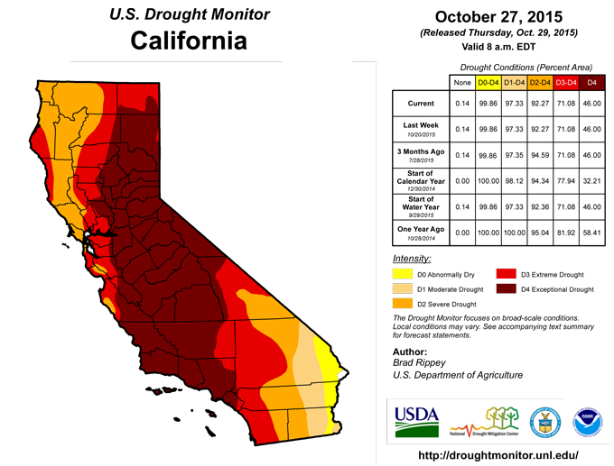
Precipitation began to wind down as the drought-monitoring period began, although heavy showers lingered in the Southwest. New rain and snow, along with further analysis of last week’s precipitation, led to reductions in the coverage of dryness and drought—some widespread—in the Four Corners States. Despite the recent precipitation, low reservoir levels remain a long-term concern in parts of Arizona and New Mexico. Nevertheless, flows in the upper Colorado River basin have been on the rise in recent weeks. Near the Utah-Colorado state line, the instantaneous streamflow of the Colorado River on October 28 was above 5,100 cubic feet per second, ranking in the upper one-fourth of the historical distribution for this time of year. Meanwhile, a mostly dry week led to “status quo” conditions in the hardest-hit drought areas of the Far West, including California. On October 25, California led the nation in topsoil and subsoil moisture rated very short to short (both 90%). Oregon ranked second in both categories (77% very short or short for topsoil moisture and 87% very short or short for subsoil moisture), and led the U.S. with 66% of its rangeland and pastures rated in very poor to poor condition.Looking Ahead
During the next 5 days, active weather will continue across much of the nation. As a storm system moves across eastern Canada, rain will end later today in the northeastern U.S. However, a few rain and snow showers may linger in the Great Lakes region. Meanwhile, a parade of Pacific storms will cross the Northwest, where 5-day rainfall totals could reach 5 to 10 inches (or more) west of the Cascades. Significant precipitation (locally 2 to 6 inches) will also reach the northern Rockies. The first of the Pacific storms will dip into the Southwest before tracking eastward. As a result, heavy rain will return to parts of the south-central U.S. and quickly spread eastward. Five-day rainfall totals of 2 to 4 inches can be expected from the southeastern Plains to the southern Appalachians. In contrast, little or no precipitation will occur across the northern Plains and southern California. Elsewhere, mild weather in the western U.S. will be replaced by sharply colder conditions early next week.The NWS 6- to 10-day outlook for November 3 – 7 calls for the likelihood of warmer-than-normal weather across the eastern two-thirds of the U.S., while below-normal temperatures will cover the West. Meanwhile, wetter-than-normal conditions across the majority of the nation will contrast with below-normal precipitation in the Pacific Northwest, the Northeast, and lower Southeast.
Author(s):
Brad Rippey, U.S. Department of Agriculture
Dryness Categories
D0 ... Abnormally Dry ... used for areas showing dryness but not yet in drought, or for areas recovering from drought.Drought Intensity Categories
D1 ... Moderate DroughtD2 ... Severe Drought
D3 ... Extreme Drought
D4 ... Exceptional Drought
Drought or Dryness Types
S ... Short-Term, typically <6 months (e.g. agricultural, grasslands)L ... Long-Term, typically >6 months (e.g. hydrology, ecology)
Source: National Drought Mitigation Center

