


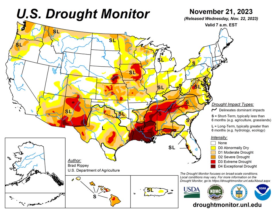
California and National Drought Summary for November 21, 2023
Summary
November 22, 2023 - During much the drought-monitoring period ending November 21, mostly dry weather dominated the country, aside from some downpours in Florida and environs. By November 20-21, however, a storm system crossing the central and eastern U.S. slowed a rapid fieldwork pace but delivered much-needed rain in some of the nation’s key drought areas, including the South. According to the U.S. Department of Agriculture, the U.S. corn harvest was 93% complete by November 19, ahead of the 5-year average of 91%. On the same date, harvest progress numbers for sorghum (96% complete), peanuts (92%), and cotton (77%) were also ahead of average. Until the arrival of the late-period storm, precipitation was mostly confined to a few small areas—across the lower Southeast and from the Ohio Valley into the Northeast. However, parts of Florida’s peninsula received excessive rainfall (4 to 10 inches or more), as a non-tropical storm system grazed the region. Some precipitation also fell in the West, with many of the highest totals in portions of the Pacific Coast States. For the second week in a row, near- or above-normal temperatures prevailed nearly nationwide.
Northeast
Mostly dry weather during the drought-monitoring period led to some expansion of abnormal dryness (D0) and moderate to severe drought (D1). Still, drought had a relatively small Northeastern footprint, due to antecedent wetness in many areas. Rain was on the doorstep of the region as the monitoring period ended; a reflection of that precipitation will appear next week. By November 19, the U.S. Department of Agriculture rated topsoil moisture 57% very short to short in West Virginia, highest in the region.
Southeast
Mixed conditions existed during the drought-monitoring period, with torrential rainfall in parts of Florida contrasting with worsening dryness or drought farther north. By November 21, at the end of the period, significant rain overspread western sections of the region, including Alabama, arresting drought intensification. On November 19, before the rain arrived, the U.S. Department of Agriculture rated topsoil moisture 83% very short to short in Alabama, while 64% of the state’s pastures were rated very poor to poor. Effects of any rain that fell after the data cutoff on November 21 will be reflected next week. Earlier in southern Florida, November 13-16 rainfall officially reached 12.47 inches in North Fort Lauderdale; 10.76 inches in Fort Lauderdale; 10.26 inches in Pembroke Pines; 9.89 inches in Opa Locka; and 8.84 inches in Miami. For all those locations, the heaviest rain fell on November 15, with Miami reporting 7.53 inches. That represented the wettest November day in Miami since November 18, 1992, when 7.56 inches fell. It was also Miami’s wettest day during any time of year since May 22, 2012, when rainfall totaled 9.70 inches. Meanwhile, Marathon, Florida—with 6.68 inches on the 15th—experienced its wettest November day on record (previously, 4.58 inches on November 14, 1954). Significant winds accompanied Florida’s rain, with gusts on November 16 clocked to 57 mph in West Palm Beach; 51 mph in Fort Lauderdale; and 48 mph in Miami. Early on the 16th, an unofficial gust to 86 mph was recorded at Carysfort Reef Light, about 8 miles east-southeast of North Key Largo, Florida. Florida’s rain eventually shifted northward, with Fort Pierce noting a daily-record sum (4.33 inches) for November 16. Fort Pierce collected another record-setting total, 2.37 inches, on November 17
South
Precipitation fell in some areas both early and late in the drought-monitoring period. In Texas and environs, beneficial impacts from previous rainfall necessitated further improvement in the drought situation, in addition to last week’s changes. Farther east, heavy showers and locally severe thunderstorms overspread the Mississippi Delta and neighboring areas late in the monitoring period, with modest reductions in the coverage of exceptional drought (D4) in parts of Louisiana and Mississippi. On November 19, prior to the arrival of significant rainfall, pastures were rated at least 60% very poor to poor in Mississippi (69%), Tennessee (61%), and Louisiana (60%). On the same date, Mississippi led the region with topsoil moisture rated 82% very short to short, followed by Louisiana at 81% and Tennessee at 64%.
Midwest
Precipitation arriving late in the drought-monitoring period provided only limited relief in drought-affected areas. Some areas that missed most of all of the moisture turned a bit drier. On November 19, prior to the storminess, Iowa led the Midwest with topsoil moisture rated 69% very short to short, followed by Missouri at 64% and Kentucky at 56%.
High Plains
There were few changes in the drought depiction, despite some light to moderately heavy precipitation late in the monitoring period. By November 19, Kansas led the High Plains with topsoil moisture rated 68% very short to short, followed by Colorado at 64% and Nebraska at 55%. On that date, Kansas also led the U.S. with 32% of its winter wheat rated in very poor to poor condition, nearly twice the national value of 17%.
West
Generally light to locally moderately heavy rain and snow showers dotted the West. There were some additional improvements in the drought situation in the Northwest, and some slight further deterioration in the southern Rockies and environs. New Mexico led the West on November 19 with topsoil moisture rated 77% very short to short.
Caribbean
In Puerto Rico, weekly rainfall totals exceeding 2 inches were mostly limited to a few western municipalities. The heavier showers bypassed areas experiencing abnormal dryness (D0) and moderate drought (D1), resulting in no changes to the Puerto Rican depiction.
This USDM week (November 15-21) was dominated by a dry, stable air mass over the USVI (U.S. Virgin Islands) associated with a high pressure ridge. A tropical disturbance (what was called Potential Tropical Cyclone 22) moved near the region later in the week, but its rain kept generally to Puerto Rico and westward, mostly missing the USVI. Weekly rainfall totals, based on data available at the time of this report, mostly ranged from zero to a third of an inch on St. Croix, with one report of 0.66 inch, and ranged from a tenth to a half of an inch on St. Thomas and St. John.
Based on USGS well observations, groundwater levels continued rising on St. John, continued falling on St. Thomas, and rose then leveled off on St. Croix. The depth to water level was 5.92 feet on St. John and 6.09 feet on St. Thomas, both of which are in the top third of the recent historical record, but 33.38 feet on St. Croix, which is in the lowest third of the historical record. Satellite observations (VHI) still showed some stressed vegetation on St. Croix.
On St. Croix, rainfall totals for October ranged from 4.59 inches to 9.74 inches, and thus far in November ranged from 2.62 to 6.61 inches. With a wet October and wet early start to November, the status on St. Croix was improved to D1-L in spite of subnormal rainfall this week. Long-term severe drought (D2-L) continued on St. Thomas, while St. John continued with a D-Nothing status (no drought or abnormal dryness).
Pacific
Alaska remained completely free of abnormal dryness (D0), as unsettled weather prevailed. In southeastern Alaska, Ketchikan collected 8.33 inches of rain from November 16-18. In south-central Alaska, Anchorage achieved its snowiest November on record, with 39.2 inches falling by the 20th. The previous November record in Anchorage, set in 1994, had been 38.8 inches.
In Hawaii, a weakening cold front delivered beneficial showers across the western islands, especially Kauai. Aside from some localized improvement in windward sections of Kauai (removal of abnormal dryness, D0), Maui (from severe to moderate drought, D2 to D1); and the Big Island (from D2 to D1), the general trend was for gradually worsening drought. This included the addition of extreme drought (D3) along the southwestern coast of Oahu, as well as the Big Island’s “saddle” region between Mauna Kea and Mauna Loa.
USAPI (U.S.-Affiliated Pacific Islands) Overview: Several tropical systems brought rain to much of Micronesia during this U.S. Drought Monitor (USDM) week (November 15-21); only a few areas received less than the minimum precipitation needed to meet most water needs. Monthly rainfall totals so far this November have been wet (above month-to-date minimums) across the Marianas, Palau, and most of the Marshall Islands. Parts of the Federated States of Micronesia (FSM) were wet and other parts dry, both for the week and for the month to date. American Samoa continued to suffer from hot temperatures and a lack of rainfall.
Rain from what was Tropical Depression 17W gave Palau a wet week, with weekly rainfall totals around 5 inches and month-to-date totals around 8 inches, while a squall line brought mesocyclone rain to the Marianas. Weekly precipitation totals were well above 2 inches at the primary Marianas stations, with November-to-date totals from 4 to over 6 inches. All locations in Palau and the Marianas continued at D-Nothing (no drought or abnormal dryness).
A monsoon-like trough with a couple embedded disturbances brought rain to much of the FSM and Marshall Islands, although parts of the FSM missed out on the rain. Weekly and month-to-date rainfall totals were below the corresponding minimums needed to meet most water needs, based on data available at the time of this report, at Lukunor, Pingelap, and Ulithi. Lukunor reported 0.36 inch for the week and 1.52 inches for the month to date, which are below the weekly minimum of 2 inches and monthly minimum of 5.60 inches for this far in November. Ulithi had 0.50 inch for the week and 2.63 inches for November, while Pingelap reported 1.01 and 3.64 inches, respectively. For each of these stations, this week marked the third consecutive dry week, so their status was changed to D0-S (short-term abnormally dry). At Yap and Wotje, this week and the month to date were below the corresponding minimums, but the previous week was wet, so their status remained at D-Nothing. With this week wet and/or the month-to-date wet, the rest of the locations in the Marshalls and FSM continued at D-Nothing.
A strong high pressure system over American Samoa inhibited precipitation this week and brought unusually hot temperatures that prompted heat advisories. A record high temperature occurred at Pago Pago on November 15 when the reading reached 91 degrees F. The last 2 weeks have been dry, with only 0.14 inch and 0.55 inch of rain recorded at the Pago Pago airport last week and so far this week, respectively. The month-to-date total was 1.93 inches at Pago Pago and 2.75 inches at the automated station on Toa Ridge, both of which are below corresponding minimums. With the previous week and October wet, D-Nothing continued at Tutuila this week, but D0-S may be considered next week if dry conditions continue.
Looking Ahead
A low-pressure system crossing the Midwest will gradually weaken and drift eastward, while a trailing cold front will largely clear the Atlantic Seaboard by Wednesday. Additional rainfall across the eastern one-third of the U.S. could reach 1 to 3 inches, especially in the middle Atlantic States. Thanksgiving Day, November 23, will feature mild, dry weather across much of the country, although snow may blanket portions of the northern and central Rockies. The generally quiet pattern should last through the weekend after Thanksgiving, with most areas experiencing seasonable temperatures and minimal precipitation. In fact, negligible precipitation is expected during the next 5 days in much of the Mississippi Valley, as well as an area stretching from California to Texas.
The NWS 6- to 10-day outlook for November 27 – December 1 calls for the likelihood of near- or below-normal temperatures and precipitation across most of the country. Warmer-than-normal weather will be confined to southern Florida and areas along the Pacific Coast, as well as the nation’s norther tier from Washington to Montana. Meanwhile, wetter-than-normal conditions should be limited to the Deep South, from the southern half of Texas to the southern Atlantic Coast.
Author(s):
Brad Rippey, U.S. Department of Agriculture
Richard Heim, NOAA/NCEI
Dryness Categories
D0 Abnormally Dry—used for areas showing dryness but not yet in drought, or for areas recovering from drought.
Drought Intensity Categories
D1 Moderate Drought
D2 Severe Drought
D3 Extreme Drought
D4 Exceptional Drought
Drought or Dryness Types
S Short-term, typically less than 6 months (agriculture, grasslands)
L Long-term, typically more than 6 months (hydrology, ecology)
SL Area contains both short- and long-term impacts
Source: National Drought Mitigation Center

