


California and National Drought Summary for November 3, 2015
Summary
A series of storm systems swept across the lower 48 States, generating wet weather that soaked many portions of the contiguous U.S., including a second round of heavy rains that provided drought improvement and relief to the southern Great Plains and Mississippi Delta. Unfortunately, the rains were accompanied by severe weather and flash flooding in Texas, including a record daily total of 14.99 inches at Austin (5.76 inches in one hour) on October 30, and an EF2 tornado in Floresville that damaged the high school. Additional dryness or drought relief from moderate to heavy rains (more than 2 inches) also occurred across most of the Southeast, west-central Corn Belt and western Great Lakes region, Ohio and Tennessee Valleys, much of the Atlantic Coast States, and the Pacific Northwest, northern Rockies, and Sierra Nevada. Heavy precipitation also fell on interior and northeastern Puerto Rico and along the southeastern Alaskan Panhandle. Weekly temperatures generally averaged above to much-above normal in the lower 48 States, with near to below-normal readings limited from the Southwest northeastward into the middle Mississippi Valley, and in interior New England.Alaska and Puerto Rico
In Alaska, light precipitation (0.2-0.7 inches) fell on western and southwestern sections while little or no precipitation was measured in northern and eastern areas. Weekly totals exceeding 2 inches were limited to the southeastern Panhandle and Kodiak Island. Temperatures averaged slightly above normal for the week. With winter conditions across the state, no changes were made to the existing D0 in the interior areas; however, the impact type (SL) was changed to L to reflect the locked in winter conditions, and that August and September were generally wet.In Puerto Rico, scattered light to moderate (0.5-2 inches), and occasionally heavy (2-8 inches) showers fell on interior locations, especially in western sections where there was no drought. In south-central (northern Ponce and Juana Diaz, Villalba) and northeastern (Dorado and Toa Baja) areas, however, 3-6 inches was enough to trim back some of the D1 edges. Elsewhere, adequate rain fell to prevent deterioration but not enough to eliminate the accumulated deficits from the spring and summer.
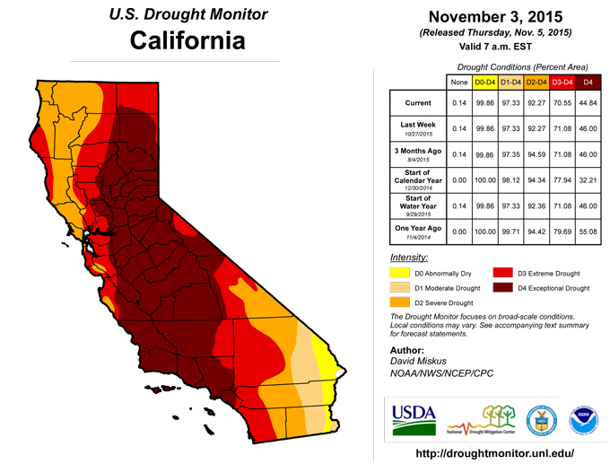
California and Great Basin
An early-season, moisture-laden Pacific storm system brought beneficial precipitation (including snows to higher elevations) to extreme northwestern and central California, including 2-3.5 inches of precipitation to the Sierra Nevada and northeastward across west-central and northeastern Nevada. The precipitation (and snow) was an early bonus to the 2015-16 Water Year in the Sierras, but with 4 consecutive years of drought, this precipitation was just a start to moisten the soils for hopefully more (frozen preferred) precipitation this winter, thus no changes were made in the Sierras. However, according to the NRCS Snotel sites, it was refreshing to see the Sierra average basins WYTD (since Oct. 1) precipitation and snow water content at 152-170% of normal and 608-1150% of normal, respectively, as of Nov. 3, but one must remember that normal are quite small early in the Water Year, so huge percentages can occur with a wet start (but better wet than dry). Additionally, the Impact Lines were redrawn to reflect where recent wetness has occurred (L only) versus where much-below normal short-term precipitation was recorded (SL).In contrast, the past 6 months have been unusually wet in parts of the semi-arid Great Basin (200-300% of normal precipitation, surpluses of 4-8 inches), especially in extreme eastern California (east of Sierra range) and western Nevada. This has led to minimal fall wild fires, decent pasture and range conditions, and adequate soil moisture. Although the Nevada statewide reservoir levels were still dismal (Oct. 1: at 5% capacity, normal=35%) and will require ample mountain snowpack this winter, the past 6 months wetness (from all tools) in a semi-arid environment is significant and a good start to the 2015-16 Water Year. Therefore, D4 was improved to D3 in western Nevada (southwest Pershing, northwest and southern Churchill, southern Lyon, and western Mineral counties) and eastern California (northern Mono county) to reflect this recent moisture. In addition, some D3 to D2 improvement was made farther south along the CA-NV border (southern Nye and east-central Inyo counties) where the past 3-6 months have NOT been arid.
Midwest and Great Lakes region
Similar to the southern Plains and Delta (minus the magnitude of the rain totals), widespread light to moderate (0.5-2 inches) and occasionally heavy (2-6 inches) rains fell on much of the Midwest and Great Lakes region, halting or ending a general expansion of abnormal dryness or drought in most of this region. With lower temperatures, little or no evapotranspiration, and (still) unfrozen ground, rainfall during the autumn can go a long way in recharging the soil moisture. As a result, D1 was improved 1-2 categories in northwestern Tennessee, western Kentucky, and south-central Indiana where a large band of 2-6 inches of steady, all-day rains greatly eased or erased short-term deficits. Similarly, 2-4 inches in central Kentucky, southeastern Indiana, and southwestern Ohio eliminated abnormal dryness. In southwestern Wisconsin, 2-3 inches of rain was enough for a 1-category improvement, but not so in southwestern Minnesota and northeastern Iowa where totals (0.5-1.5 inches) were not enough to significantly reduce deficiencies. Light to moderate rains also halted the expansion of short-term dryness and drought in the western Great Lakes region, and actually trimmed away some of the D0 and D1 edges where the totals were large enough (northern Wisconsin, UP of Michigan, northern lower Michigan). In Missouri and southeastern Iowa, bands of moderate to heavy rain (1.5-2.5 inches) allowed for some trimming of the D1 edges, along with a bit of D0 and D1 improvement in central Illinois (1.5 to 2 inches of rain). Not surprisingly, the NASS/USDA statewide topsoil moisture rated short to very short came down (improved) 10-34 percentage points on Nov. 1 from the previous week in Wisconsin, Iowa, Missouri, Illinois, Indiana, Ohio, Michigan, Kentucky, and Tennessee, although Missouri, Illinois, and Indiana was still at 42, 38, and 38%, respectively.Mississippi Delta and Southern Plains
Extreme precipitation events seem to be the norm in this region as a sudden (1-2 weeks) end to the 3-month flash drought neared reality. Two swaths of copious rains (more than 8 inches), one between San Antonio and Austin, TX, and another from Houston, TX, to north of Alexandria, LA, produced flash and river flooding, with at least 5 fatalities in Texas. Needless to say, after the previous week’s rainfall, these amounts were more than enough to eliminate the remaining D1 and D0 across south-central and southeastern Texas and the southern two-thirds of Louisiana. In addition to these incredible totals, widespread moderate to heavy rains (2-6 inches) were measured across the eastern two-thirds of the state, south-central Oklahoma, central Arkansas, nearly all of Louisiana and the southern two-thirds of Mississippi. A widespread 1- to occasionally 2-category improvement was made in these areas as all D2 was removed. According to the Texas Water Development Board, statewide reservoirs stood at 82.1% full as of Nov. 4, continuing to climb after falling from 85% to 77% full during the flash drought. In addition, the Texas state climatologist John Nielsen-Gammon estimated that October 2015 statewide precipitation stood at 6.51 inches (previous Oct. record 6.26 inches in 1919), making 2015 the third year with at least two monthly records (May and October). The other two years were 2004 (June and November) and 2007 (March and July). Short to very short topsoil moisture dropped to 16, 19, 5, and 16% in Texas, Arkansas, Louisiana, and Mississippi, respectively, as of Nov. 1, down from 32, 48, 39, and 58% the previous week, according to NASS/USDA. Residual areas of D1 and D0 remained where 2-week precipitation totals were lower and larger 90-day deficiencies remained, however, the numerous reports of drought impacts a few weeks ago have instead turned to excessive moisture problems.Northern and Central Plains
Weekly totals were much lower across the northern and central Plains as compared to areas to the south and east; however, in North Dakota, timely rains (0.2-0.7 inches) helped improve the condition of the winter wheat while farmers utilized the dry weather to continue harvesting corn and sunflower seeds which were done well ahead of normal. Even though little or no rain fell on South Dakota, 90-day surpluses, lower temperatures, and minimal evapotranspiration have kept the D0(S) from worsening. In southern Nebraska and eastern Kansas, light to moderate (0.3-0.9 inches) rains generally kept conditions stable, although a reassessment of short-term tools led to a slight redraw of the D1 areas in Kansas and D0 in southwestern Nebraska. In southwestern Colorado and southwestern Kansas, 0.6-1.5 inches of rain, locally to 2.5 inches, plus heavy rains from last week, were enough to eliminate the D0 in Kiowa, Cheyenne, and Prowers counties (Colorado), and Greeley and Hamilton counties (Kansas).Pacific Northwest and Northern Rockies
A constant barrage of Pacific moisture and storm systems brought daily precipitation, quite heavy during mid-week, to coastal Washington, northwestern Oregon, the northern Cascades, and northern Rockies. For the week, totals ranged between 6-15 inches in the first three areas, and 2-6 inches in the latter region. With this week’s copious amounts and wet weather during the past 3-4 months, 1-category improvements were made to areas with the greatest amounts, namely western Washington and northwestern Oregon (D2 to D1), central coastal Oregon (D3 to D2), western side of Cascades (D3 to D2), northeastern Washington, northern Idaho, and northwestern Montana (D3 to D2), and north-central Montana (D0 to D2 1-cat improvements; Glacier, Pondera, Teton, and Toole counties), the latter which was wet out to 180-days. Similarly, some D0 was removed from eastern Montana as the short-term indices were either normal or wet. Just like many basins in the West, this early Water Year (since Oct. 1) precipitation is welcome to moisten the soils, but it will take ample winter precipitation in the form of mountain snows to truly replenish the depleted reservoirs next spring, especially in Oregon. In contrast, short-term dryness (past 3 months) in central sections of Wyoming expanded the D0(S) in this state.Southeast
The upper-air low that inundated Texas and the Delta gradually tracked into the Southeast late in the week, dumping heavy rains on the central Gulf northeastward across Georgia, the Carolinas, and into Virginia. The rains, however, missed most of Florida (minus the western Panhandle) and southeastern Georgia. The flash drought that had affected the southern Plains and Mississippi Delta for 3 months (mid-July to mid-October) was slowly expanding eastward, but this week’s precipitation put a damper on the dryness. From western Alabama into east-central Georgia, 2-4 inches, locally to 8 inches, improved most of the D1 to D0, and eliminated some of the D0 where the amounts were largest. According to NASS/USDA, topsoil moisture rated short to very short for both Alabama and Georgia stood at 30% as of Nov. 1, down from 58% and 42% a week prior, respectively. And this did not include the heavy rains of Nov. 2 and 3. In contrast, only light rains fell on the central Florida Panhandle (Apalachicola to Tallahassee) and points east and south. With short-term (90-days) dryness increasing in parts of the state, D0 was expanded in the central Panhandle and extreme southern Florida, and added to east-central (Space) coast.Southwest
Although precipitation was generally light (about 0.5 inches) across Arizona and New Mexico, slight adjustments were made based upon numerous indices (especially the station SPIs) out to 12-months that depicted wetness across the D1 areas of northern Arizona and northwestern New Mexico in order to better match the conditions in neighboring states (southern Utah and Colorado). This is similar to the changes made in the Great Basin (Nevada). As a result, D1 was improved to D0 across northern and central Arizona and a bit in northwestern New Mexico (Cibola County). In addition, some D1 was returned to southern Yavapai County, AZ, to better reflect long-term deficits. Based upon the Oct. 1 USDA/NRCS statewide reservoir storage data, however, Arizona and New Mexico were still below normal (35% and 28% capacity versus normal of 49% and 42%, respectively), so ample winter precipitation (decent mountain snowpack) is still needed to offset the long-term hydrologic (reservoir) shortages.The Northeast
Early in the period, widespread showers and thunderstorms dropped moderate (1-2 inches) to occasionally heavy (2-4 inches) rain on much of New England and the mid-Atlantic, ending a 3-week stretch of relatively dry weather. Since the past few weeks were mostly dry, this week’s rains were not enough to make many improvements except where the heaviest rains fell on D0 areas, thereby greatly reducing or eliminating 90-day shortages. This included removal of some small D0 in northwestern and northeastern Pennsylvania, upstate New York, and north-central West Virginia. The larger D0-D1 area along the New England coast remained unchanged as those deficits are also long-term (going back 1 to 2 years), and will need a sustained period of surplus precipitation to eliminate them. This was demonstrated by the USGS average stream flows that quickly dropping back to below (10-25th) or much below (less than 10th) normal flow percentiles in early November in the D1 area just a few days after 1.5-3 inches of rain fell on October 28-29.Looking Ahead
For the upcoming 5-day period (November 5-9), moderate to heavy (1-3 inches) precipitation is expected from the southern Great Plains northeastward into the eastern Ohio Valley. Light to moderate precipitation (0.5-1.5 inches) is forecast from Louisiana eastward to the North Carolina Outer Banks, southern Florida, the central Great Lakes region, parts of the Rockies, and the Pacific Northwest. Little or no precipitation should occur in most of California and the Great Basin, the High Plains, and the Northeast. Temperatures should average below-normal in the western third of the Nation, and above normal in the northern half of the Plains and eastern third of the U.S.For the ensuing 5 days (November 10-14), the odds favor above median precipitation in the Pacific Northwest, central Rockies, north-central and southern Plains, Midwest and Great Lakes region, New England and mid-Atlantic, and most of Alaska except sub-median chances in the southwest. Below median odds are likely from central California northeastward into western North Dakota. Below-normal temperatures are favored in the West and Alaska, and above-normal readings in the eastern half of the Nation.
Author(s):
David Miskus, NOAA/NWS/NCEP/CPC
Dryness Categories
D0 ... Abnormally Dry ... used for areas showing dryness but not yet in drought, or for areas recovering from drought.Drought Intensity Categories
D1 ... Moderate DroughtD2 ... Severe Drought
D3 ... Extreme Drought
D4 ... Exceptional Drought
Drought or Dryness Types
S ... Short-Term, typically <6 months (e.g. agricultural, grasslands)L ... Long-Term, typically >6 months (e.g. hydrology, ecology)
Source: National Drought Mitigation Center

