


California and National Drought Summary for December 5, 2023
Summary
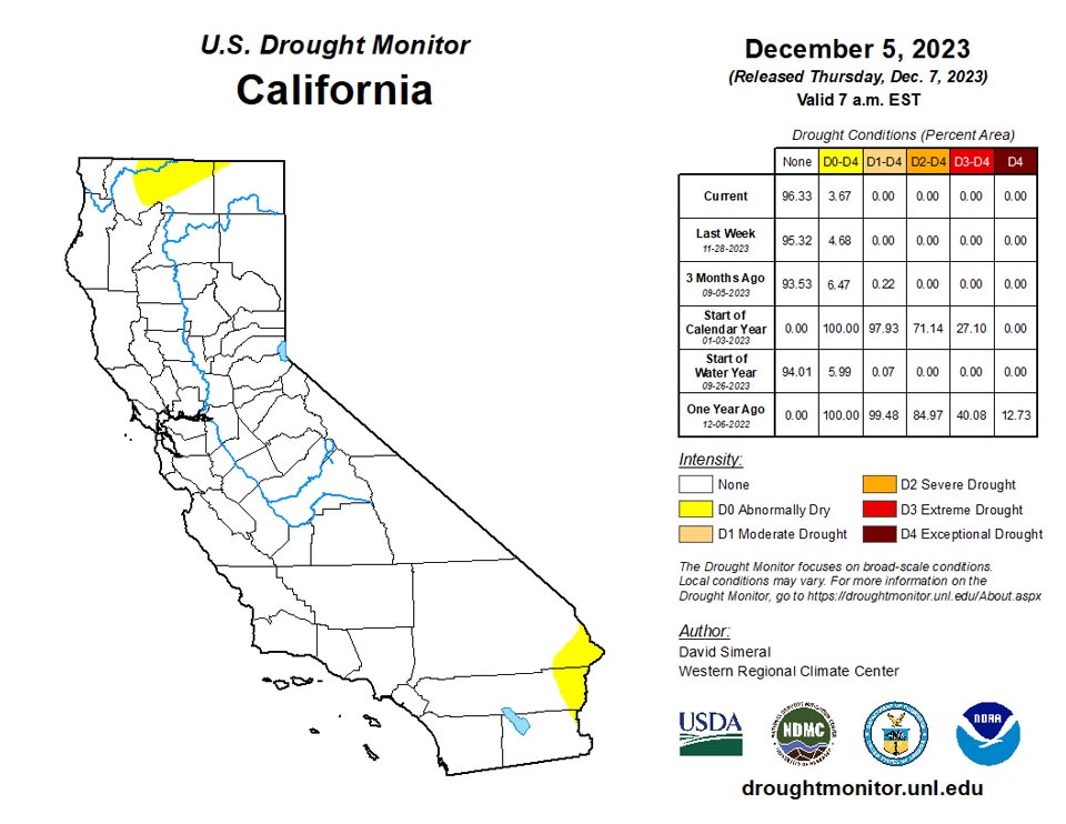
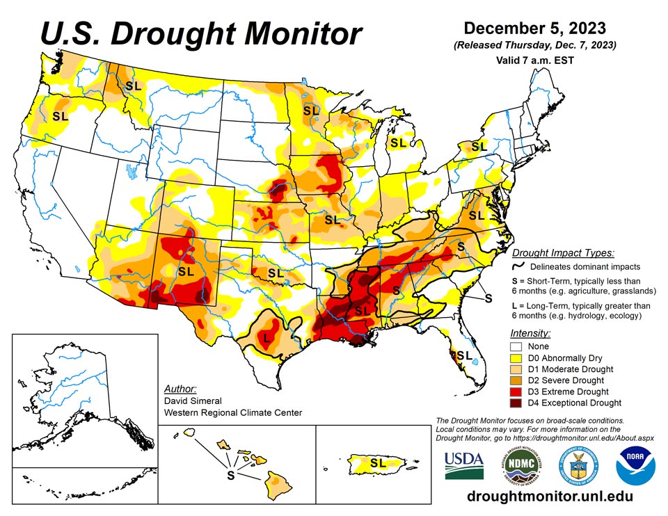
December 7, 2023 - This U.S. Drought Monitor (USDM) week saw continued improvements on the map in drought-affected areas of the South, Southeast, and Pacific Northwest. In the South and Southeast, heavy rains over the weekend impacted areas of the Mid-South, and Gulf Coast states with isolated locations in southern Louisiana and the Florida Panhandle receiving up to 7-inch accumulations. In the Pacific Northwest, a series of atmospheric rivers delivered heavy rainfall to western Oregon and Washington as well as significant mountain snow to the higher elevations of the Olympic Peninsula, Cascade Range, and the Blue Mountains of northeastern Oregon. Some of the highest precipitation accumulations (8-15+ inches liquid) were observed in the Olympic Mountains, Cascades of southwestern Washington, and in the coastal ranges of west-central Oregon. Further inland, higher elevations in central Idaho and northwestern Montana ranges, Northern Great Basin ranges, the Tetons and Wind River ranges in northwestern Wyoming, the Wasatch Range in northern Utah, and the Colorado Rockies all received significant snowfall accumulations that helped to boost snowpack levels closer to normal to above normal levels. Likewise, high-elevation snows were observed in the mountains of the Southwest including along the Mogollon Rim and Chuska Mountains of Arizona as well as in the Nacimiento and Sangre de Cristo ranges of New Mexico. In California, snowpack conditions continue to lag normal levels with the statewide snow water equivalent (SWE) at 29% of normal (12/5). According to the Natural Resources Conservation Service (NRCS) SNOTEL network (12/5), region-wide (2-digit HUCs) percent of median snow water equivalent (SWE) levels were as follows: Pacific Northwest 73%, Souris-Red-Rainy 70%, Missouri 73%, California 73%, Great Basin 102%, Upper Colorado 86%, Lower Colorado 78%, Rio Grande 65%, and Arkansas-White-Red 64%. In areas of the Midwest, Great Lakes, and northern New England, light-to-moderate snowfall accumulations (ranging from 1 to 12+ inches) were observed during the past week with the highest totals (12+ inches) reported in areas of Vermont, New Hampshire, and Maine. In areas of the Hawaiian Islands, locally heavy showers and flash flooding were observed last week in association with a Kona Low system that helped to ease drought conditions across the island chain.
Northeast
For the week, some minor improvements were made on the map in Upstate New York, New Jersey, and Maryland in response to improving conditions during the past 30-60-day period. In contrast, areas of Abnormally Dry (D0) expanded in southeastern Pennsylvania in response to dry soils and short-term dryness (past 30-60 days). In other parts of the region, some locally heavy snowfall accumulations (up to 18 inches in northern Maine) were observed in the Adirondacks of Upstate New York, northern Vermont and New Hampshire, and Maine. According to the National Weather Service (NWS) National Operational Hydrologic Remote Sensing Center (NOHRSC) regional snow analysis (12/6) reports that the Northeast Region is 64.9% covered by snow with an average snow depth of 3.7 inches and a maximum depth of 25.2 inches, while the Southern Great Lakes Region (which includes areas downwind of Lake Erie and Lake Ontario) was 21.7% covered by snow. For the week, average temperatures were above normal across much of the region with departures ranging from 1 to 5+ degrees F above normal. Some pockets of cooler-than-normal temperatures were observed in the eastern half of Pennsylvania, Maryland, and New Jersey.
Southeast
During the past week, light to heavy rainfall accumulations (ranging from 1 to 6 inches) were observed across areas of the region, with the highest accumulations observed in isolated areas of the Florida Panhandle and southwestern Georgia. In response, one-category improvements were made in drought-affected areas of Alabama, Florida, and Georgia. Conversely, areas of Extreme Drought (D3) expanded on the map in western portions of the Carolinas where dry conditions have prevailed during the past 30-90-day period and widespread very low streamflow levels (< 10th percentile) were observed during the past week. Average temperatures across most of the region were near to above normal (1 to 4 degrees F) for the week, with the greatest departures observed along the coastal plains of Georgia and in the Carolinas. According to the latest U.S. Department of Agriculture Florida Crop Progress and Condition Report (12/4), rainfall during the past few weeks has helped improve drought conditions, winter crops, and forages. Additionally, many reports have come in that temperatures and precipitation have been optimal for sugar cane and leafy vegetable production.
South
In the South, locally very heavy rainfall (up to 9 inches) was observed along the Gulf Coast regions of Texas, Louisiana, and Mississippi leading to one-category improvements in areas experiencing severe drought conditions. In Texas, areas of Extreme Drought (D3) expanded on the Edwards Plateau and South Central due to a combination of factors including long-term precipitation deficits and poor hydrologic conditions (streamflows, groundwater, and reservoir storage). Statewide reservoir conditions in Texas were at 68% full (12/6), with some poor conditions being reported including in the San Angelo area reservoirs which were at 22.9% full, according to Water Data for Texas. In northeastern Oklahoma, recent precipitation events led to some minor improvements in areas of Moderate Drought (D1) and Severe Drought (D2) while areas of Abnormally Dry (D0) were added in the Panhandle region. According to the Oklahoma Mesonet (12/5), the Panhandle region has gone 64 consecutive days with less than 0.25 inches of rainfall. In Tennessee, reductions in areas of Severe Drought (D2) and Extreme Drought (D3) were made on the map in response to precipitation during the past 14-day period. However, 4-to-8-inch precipitation deficits (60-day period) remain across the state as well as areas with poor surface water conditions.
Midwest
For the week, some light precipitation accumulations (generally < 1 inch liquid) were observed in the region including some light snowfall, mixed rain-snow, and rain. The drought situation across part of the region has been complicated by a mix of wet/dry signals in the drought indicators during the past 30-90-day period. In terms of hydrologic conditions, the U.S. Geological Survey (USGS) is reporting numerous creeks and rivers with 14-day average flows below the 10th percentile in Iowa, Missouri, Illinois, Indiana, Michigan, and Ohio. Likewise, below-normal soil moisture conditions are showing up in areas of the region (particularly Iowa) on the NASA GRACE surface and root-zone soil moisture drought indicator as well as on the NASA SPoRT products. Looking at snowpack conditions, the NWS NOHRSC reports 56.2% of the Northern Great Lakes Region is covered by snow with an average depth of 0.8 inches and a maximum of 6.5 inches. Average temperatures for the week were generally above normal (2 to 10 degrees F) across the region with the greatest anomalies observed across northern Minnesota, while cooler-than-normal temperatures (2 to 4 degrees F) were observed in northern Wisconsin and northern Michigan.
High Plains
On this week’s map, some widespread one-category improvements were made across southeastern Kansas in response to precipitation during the past 30-60 days. According to the USGS, streamflow levels in the southeastern and east-central part of the state are normal to above normal. Conversely, numerous stream gauges are reporting much below-normal flows (< 10th percentile) in the central part of the state. In the Dakotas, conditions on the map remained status quo. In terms of snowpack conditions, the NWS NOHRSC reports the Upper Midwest Region (which includes the Dakotas, eastern Montana, and northeastern Wyoming) is currently 4.8% covered by snow with a maximum depth of 10 inches. Average temperatures for the week were generally above normal (2 to 10+ degrees F) with the greatest departures observed in the Dakotas. Today (12/5), high temperatures in North Dakota are expected to reach near 60 degrees F.
West
On the map, improvements were made across areas of the Southwest and Pacific Northwest including New Mexico, Oregon, and Montana. In northern New Mexico, areas of Extreme Drought (D3) were reduced in response to recent precipitation (past 14-day period) including high-elevation snowfall in the Nacimiento and Sangre de Cristo ranges. According to the NRCS SNOTEL network (12/5), sub-basin (8-digit HUCs) percent of median SWE levels were above normal in several New Mexico sub-basins including: Rio Grande-Santa Fe 116%, Jemez 170%, Chaco 161%, Rio Puerco 212%, and Upper Gila 192%. In the Pacific Northwest, an extended atmospheric river event delivered much-needed precipitation to the region including heavy rains and high elevation snowfall in western portions of Oregon and Washington as well as in the far northwestern corner of California, leading to one-category improvements on the map. According to the USGS, streamflow levels across western Washington and Oregon are ranging from normal (southern Oregon) to well above normal (northwestern Oregon and western Washington). The highest flows, including areas with severe flooding (i.e., Skagit and Snohomish rivers), were observed in western Washington. For the week, average temperatures across the region were generally above normal (2 to 8 degrees C) with the greatest positive departures observed in central portions of Oregon and Idaho and across the eastern two-thirds of Montana.
Caribbean
In Puerto Rico, areas of Abnormally Dry (D0) expanded across much of the Cordillera Central in response to low streamflows and precipitation shortfalls during the past 30-60-day period. Additionally, an area of Moderate Drought (D1) was added in eastern Puerto Rico where streamflows have dipped below the 10th percentile, according to the USGS.
This week, drier-than-normal conditions continued across the U.S. Virgin Islands. The weekly rainfall reports showed that both St. Thomas and St. Croix had less than 0.4 inches of rain this week. The 1-, 3-, 6-, 9- and 12-month SPI maps also showed that short- and long-term drought conditions prevailed on St. Thomas and long-term drought condition persisted on St. Croix. In contrast, St. John remained free from drought condition this week.
Specifically, St. John (Rafe Boulon/Windswept Beach) received 0.13 inches of rain this week. The depth to water level at Susannaberg DPW 3 well (St. John, USVI) on 5 December 2023 was 5.62 ft below land surface. The water level below the land surface slightly increased this week but remained below 6 ft (i.e., shallow depth). Thus, St. John remained free of drought.
St. Thomas (Cyril E. King Airport) recorded no rain this week. The depth to water level Grade School 3 well (St. Thomas, USVI) on 5 December 2023 was 8.76 ft below land surface. An increase in depth to water level this week was observed as compared to last week (which was 7.92 ft). This confirms the persistence of the severe drought condition. Thus, St. Thomas remained in short- and long-term severe drought condition (D2-SL).
St. Croix (Henry Rohlsen AP) reported 0.13 inches of rain this week. The depth to water level at Adventure 28 Well (St. Croix, USVI) on 5 December 2023 was 33.27 ft below land surface showing an increase from the depth of last week (32.87 ft). Thus, St. Croix remained in long-term moderate drought condition (D1-L).
Pacific
In Alaska, conditions on the map remained status quo with no drought conditions observed.
In the Hawaiian Islands, a Kona Low event brought much-needed moisture to the island chain, where rainfall accumulations during the past week ranged from 1 to 8 inches with the Big Island and Kauai receiving the highest totals. On the Big Island, the Hilo International Airport observed 6.24 inches of rain on 11/30, breaking a daily rainfall record and bringing the monthly rainfall total for November to 14.39 inches. On the map, one-category changes were made across all islands.
Most parts of the Marshall Islands were free from drought condition this week. Ailinglapalap received 1.61 inches of rain this week. However, the monthly rainfall for November was 18.74 inches so that Ailinglapalap remained drought free. This week, 2.37 inches of rain was reported on Jaluit.to remain free of drought. On Mili, 2.29 inches of rain was observed this week so that the island remains drought free. Kwajalein received 2.09 inches of rain this week, resulting in drought-free conditions. This week, 2.67 inches of rain was reported on Majuro, allowing the island to remain free of dryness. On Wotje, only 0.32 inches of rain was reported. Because the monthly rainfall in November on Wotje was also only 5.06 inches, the island remains in abnormally dry condition. No depiction was made for Utirik due to missing data.
Pago Pago reported 0.18 inches of rain this week. In addition, Pago Pago was drier than normal for the past four weeks. The November monthly total rain on Pago Pago was only 3.58 inches. In addition, Siufaga Ridge and Toa Ridge observed 0.64 and 0.12 inches of rain this week, respectively. Thus, conditions on American Samoa have deteriorated from abnormal dryness to short-term moderate drought.
Palau IAP (Airai) reported 3.14 inches of rain this week (one day missing). Koror COOP station also reported 0.72 inches of rain (five days missing). Thus, the island remained free of drought or abnormal dryness.
On Saipan, 1.62 inches of rain was observed this week. In addition, Saipan (IAP, manual gauge) and Saipan (ASOS) received 1.78 and 1.56 inches of rain, respectively. Rota and Guam also received weekly totals of 2.42 and 1.49 inches of rain, respectively. However, because of wet conditions in the past weeks, the island remained drought free.
Near-normal conditions prevailed across much of the Federated States of Micronesia. This week, Kapingamarangi and Kosrae reported 1.95 and 4.54 inches of rain, respectively, to remain free of drought. Wet conditions were observed on Pohnpei, reporting 4.95 inches of rainfall this week. Nukuoro, Chuuk, and Woleai reported 0.21, 1.35, 0.17, respectively. However, because of near-normal conditions over the islands in the past few weeks, they remain free of drought.
Lukunoch had a weekly rainfall amount of 0.27 inches with one day unaccounted for, resulting to remain in abnormally dry conditions. Yap reported rainfall totals of 0.53 inches of rain with one missing. However, except last week, wet conditions prevailed across the island in the past 3 weeks to remain free of drought. On Pingelap, 1.65 inches of rain was reported this week with 3 days missing. In addition, Pingelap had more than 8 inches of rain in November, improving to normal condition. Ulithi reported only 0.63 inches of rain with one day missing. Ulithi was drier than normal in the past six weeks. Thus, the island deteriorated to short-term moderate drought condition. No depiction was made for Fananu due to missing data.
Looking Ahead
The NWS Weather Prediction Center (WPC) 7-Day Quantitative Precipitation Forecast (QPF) calls for moderate-to-heavy precipitation accumulations ranging from 2 to 5+ inches (liquid) across western portions of Washington and Oregon as well as northwestern California, while 1 to 2+ inch accumulations (liquid) are expected in areas of eastern Washington and Oregon, Idaho Panhandle, and northwestern Montana. In the Intermountain West, accumulations around an inch are expected in areas of the northern Great Basin, and the Rockies (central and northern). In the eastern tier of the conterminous U.S., accumulations of 1 to 4 inches are expected with the heaviest totals anticipated in western North Carolina. The NWS Climate Prediction Center (CPC) 6-10 Day Outlooks call for a moderate-to-high probability of above-normal temperatures across California, Arizona, Nevada, southern Oregon as well as in the northern Plains, New England, and south Florida. Conversely, temperatures are expected to be below normal across most of the Gulf Coast region, Texas, and eastern New Mexico. In terms of precipitation, below-normal precipitation is expected across most of the conterminous U.S. except for areas of Texas, Florida, and upper New England.
Author(s):
David Simeral, Western Regional Climate Center
Tsegaye Tadesse, National Drought Mitigation Center
Dryness Categories
D0 Abnormally Dry—used for areas showing dryness but not yet in drought, or for areas recovering from drought.
Drought Intensity Categories
D1 Moderate Drought
D2 Severe Drought
D3 Extreme Drought
D4 Exceptional Drought
Drought or Dryness Types
S Short-term, typically less than 6 months (agriculture, grasslands)
L Long-term, typically more than 6 months (hydrology, ecology)
SL Area contains both short- and long-term impacts
Source: National Drought Mitigation Center
