


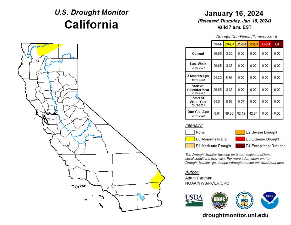
California and National Drought Summary for January 16, 2024
Summary
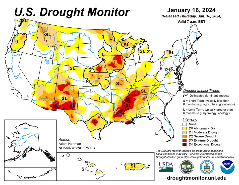
January 18, 2024 - It was another stormy week across much of the eastern lower 48 states leading to widespread drought improvements from the Mississippi River Valley eastward to the Appalachians. A powerful storm system early in the week (January 9-10) brought heavy rainfall to parts of the eastern U.S., with most locations from Georgia to New England picking up more than 2 inches of precipitation, leading to flooding for several locations. In some locations across the Mid-Atlantic and interior Northeast, flooding was exacerbated by melting snow left over from a winter storm hitting the region the previous weekend (January 6-7). Behind the powerful storm system early this week, cold air plunged southward from Canada across the northern tier states, gradually spreading southward and eastward and overtaking most of the country east of the Rockies by the end of the week (January 16). Toward the end of the week, another storm system dropped wintry precipitation in a swath stretching from the Ozarks eastward to the Mid-Atlantic and Northeast. Across the western lower 48 states, precipitation was above average for the week, leading to targeted improvements to drought areas across the Intermountain West, where snowpack continues to build for several locations. Unfortunately, weekly precipitation and seasonal snowpack remain below normal this week across the Southwest and northern Rockies, leading to some degradation of drought conditions. No changes are warranted in Alaska this week, as the snowpack is in good shape statewide. Hawaii received more heavy rainfall this week, predominantly from a Kona Low early on, leading to improvement. Conversely, another warm and dry week in Puerto Rico warranted another round of degradation.
Northeast
A strong storm system moved up the Eastern Seaboard in the days leading up to this week, which brought heavy snowfall to parts of the Mid-Atlantic and Northeast. At the start of this week (January 9-10), another powerful storm system dropped more heavy precipitation, primarily in the form of rain, across much of the East Coast leading to flooding in several locations, which was exacerbated by snowmelt left behind by the previous storm. The heavy precipitation (well over 2 inches for many locations) warrants improvement to drought (D1-D2) and abnormally dry (D0) conditions across the central Appalachians, localized abnormally dry areas of coastal Massachusetts, and improvement to severe drought (D2) conditions in western New York. Despite the heavy rainfall region-wide, Nantucket and Martha’s Vineyard largely missed out on the heavier rainfall totals warranting no changes. Groundwater recharge remains a concern for those islands.
Southeast
Short- and long-term drought conditions improved this week throughout the Southeast, associated with the passage of a strong storm system early on in the week and another heading into the weekend. Broad 1-category improvements to the drought depiction are warranted across portions of the southern and central Appalachians and extending into the Piedmont of Virginia, where many locations received over 2 inches of rainfall this week. Improvement to ongoing drought is also warranted across the western Florida Peninsula, where heavy rains (in excess of 2 inches, and locally more than 4 inches) fell along a frontal boundary early in the week.
South
Much of the precipitation this week fell across portions of the Ozarks and Tennessee Valley, associated with a couple of storm systems leading up to the start of the weekend (January 13), with many locations receiving in excess of 1 inch of rainfall. Toward the end of the week (January 15-16), a winter storm dropped several inches of snowfall across many of these same locations. Given the wetter than average conditions last week and another round of above average precipitation again this week, widespread improvement to drought conditions are warranted across portions of Arkansas and Tennessee. In parts of southern Texas, some degradation to the drought depiction is warranted, where short-term precipitation deficits are starting to mount. No changes are warranted elsewhere across the region due to above average precipitation last week and cold temperatures spreading across the region this week.
Midwest
Precipitation well in excess of 200 percent of average for the week warrants widespread improvements to the drought depiction across the Ohio and Middle Mississippi Valleys and the southern Great Lakes. Short-term drought indicators are showing marked improvements in recent weeks and soil moisture and hydrologic conditions (such as stream flows and groundwater) continue to improve for many locations, particularly across the Corn Belt.
High Plains
Storminess in recent weeks and frigid temperatures this week warrant no changes across much of the Central and Northern Plains. However, there are mixed improvements (Colorado Plateau) and degradations (High Plains along the Front Range) warranted this week. Improvements to snowpack and short-term precipitation deficits this week warrant the improvements across the Colorado Plateau. Conversely, the lack of seasonal snow cover has led to degradations across parts of the High Plains along the Front Range, due to topsoils being exposed and drying out.
West
Some degradation of drought conditions is warranted where below average precipitation was observed this week. This is especially the case across western portions of Montana, where below average seasonal snow cover has left soils predominantly exposed, resulting in a slow decline in soil moisture over the past couple of months. On the other hand, targeted improvements are warranted across parts of the Pacific Northwest and eastern Great Basin, where 7-day precipitation totals and storminess in recent weeks have improved some of the long-term drought indicators. The active storm track in recent weeks has also led to gradual improvements to seasonal snowpack for several locations across the higher elevations of the Pacific Northwest, Great Basin, and portions of the Colorado Plateau.
Caribbean
Another week of above average temperatures and below average precipitation during what is already a dry time of the year resulted in a widespread 1-category degradation of conditions across Puerto Rico for the second week in a row. Stream flows are running well below normal throughout the island and rainfall deficits continue to climb.
A nearby front brought periods of clouds and scattered showers to the USVI this past drought week (Wed, Jan 10 – Tue, Jan 16, 2024), with maximum rainfall accumulation just over one inch. Mid to upper-level high pressure and drier air prevented the development of deep convection/widespread thundershower activity during the week. Breezy conditions ensued later in the period as building surface high pressure over the western Atlantic strengthened the pressure gradient over the northeastern Caribbean.
Satellite-based Quantitative Precipitation Estimates (QPE) from SPoRT IMERG imagery depicted rainfall amounts less than 0.75-inch during the week ending January 16th, though several rain gauges recorded locally greater amounts.
Rain gauge measurements across St. Croix this week ranged from 0.10-inch at station VI-SC-24 (Christiansted 2.1 ENE) to 0.76-inch at VI-SC-34 (Frederiksted 1.9 NE). Intermediate rainfall amounts included 0.18-inch at VI-SC-20 (Frederiksted 1.7 ESE), 0.22-inch at East Hill, 0.32-inch at VI-SC-23 (Christiansted 6.5 W), 0.37-inch at VI-SC-30 (Christiansted 1.7 SW), 0.45-inch at VI-SC-10 (Christiansted 1.6 E), 0.46-inch at VI-SC-29 (Frederiksted 2.5 NNE), and 0.75-inch at VI-SC-35 (Frederiksted 1.3 ENE). At the Adventure 28 Well, groundwater levels ranged from 32.84 feet (Jan 10, midnight) to 33.01 feet (Jan 16, 8am AST), a net fall of -0.17 feet. St. Croix’s drought depiction remains unchanged this week at D1(SL).
St. John received considerable precipitation this week, with 1.04 inches measured at VI-SJ-3 (Windswept Beach), 1.00 inch at VI-SJ-5 (Cruz Bay 1.6 E), and 0.76-inch of rain at VI-SJ-4 (Cruz Bay 0.8 NE). The groundwater level at the Susannaberg DPW-3 Well fell slightly this week by -0.32 feet. Drought-free conditions persist at St. John this week.
Weekly rainfall accumulations on St. Thomas ranged from 0.39-inch at VI-ST-5 (Charlotte Amalie West 4.2 WNW) to 0.83-inch at VI-ST-14 (Nadir 0.3E, Tropical Marine). Intermediate rainfall amounts included 0.52-inch at VI-ST-1 (Anna’s Retreat 2.5 ESE), 0.74-inch at VI-ST-15 (Charlotte Amalie West 1.3 N), and 0.79-inch of rain at VI-ST-13 (Charlotte Amalie 1.2 NNW). The Grade School 3 Well reported a water level of 10.62 feet (Jan 10, midnight) which rose +1.36 feet to 9.26 feet below the land surface (Jan 16, 8am AST). The drought depiction at St. Thomas remains unchanged this week at D2(L).
As this is early in the dry season for the northeastern Caribbean basin, there are no compelling reasons to change the drought depictions this week at any of the Islands.
Pacific
Given antecedent conditions, decent snowpack leading up to this week, and the time of year, no changes are warranted in Alaska. Alaska remains drought-free.
An area of low pressure (known as a Kona low) brought heavy rainfall to portions of the eastern Hawaiian Islands at the start of this week, leading to broad improvements to the drought depiction in Maui and the Big Island.
During this past drought week (Wed, Jan 10 – Tue, Jan 16, 2024) over the South Pacific, a surface trough and associated area of wind convergence located south and west of American Samoa brought periods of heavy rainfall and isolated thunderstorms to the islands/atolls. North of the equator, a dry trade-wind regime dominated most of the USAPI region, with the more significant rainfall (at least 1-inch) remaining south of about 6 deg N and also over the Republic of Palau. Patchy showers were reported in the vicinity of the Marianas associated with shear lines. Strong storm systems moving over the Northwest Pacific resulted in enhanced pressure gradients and stronger winds for much of the USAPI region late in the drought week. With increasingly dry conditions occurring over much of the region, any periods of strong winds are expected to increase the risk of fire danger.
Satellite-based Quantitative Precipitation Estimates (QPE) from SPoRT IMERG imagery for the past 7-days depict rainfall amounts generally under 0.75-inch over much of the USAPI region. The exceptions included southern Micronesia and the Republic of Palau (generally 2-4 inches). Over the South Pacific, rainfall accumulations ranged from 4-8 inches over the vicinity of American Samoa.
Each of the three reporting sites on American Samoa exceeded the minimum monthly precipitation to meet most water needs (4 inches) during this past week. These stations include Pago Pago (8.06 inches of rain), Siufaga Ridge (6.59 inches), and Toa Ridge (6.00 inches). This is 6-8 times the minimum weekly water threshold of 1 inch, and in the case of Pago Pago twice the monthly minimum of 4 inches. Given such heavy precipitation amounts this week, and a whopping 25 inches in December, Tutuila remains free of any dryness or drought.
The Republic of Palau continues to enjoy drought-free conditions. The Palau International Airport (Airai) received 3.62 inches of rain (1 day missing) this week, and the Koror COOP measured 2.57 inches of rain (1 day missing). Both of these rainfall totals comfortably surpassed the 2-inch weekly minimum water requirement.
Rainfall amounts recorded across the Commonwealth of the Northern Mariana Islands (CNMI) this week ranged from 0.22-inch at Guam to 1.00 inch at both Rota and the Saipan ASOS site. Additional rainfall observations include 0.85-inch at Tinian, 0.61-inch at the Saipan International Airport manual gauge, 0.41-inch at Dededo, and 0.36-inch of precipitation at Agat. Despite late gains in rainfall this week at several stations, in which the weekly minimum water requirement of 1 inch was barely met, the CNMI depictions were all degraded to D0(S).
Some of the driest conditions in recent weeks have occurred across the Republic of the Marshall Islands (RMI). Ailinglaplap measured the most rain this week, a mere 0.20-inch (1 day missing), followed by Majuro (0.11-inch of rain) and Kwajalein (0.05-inch). Majuro and Kwajalein have now experienced 4 consecutive dry weeks, and their drought designations were accordingly degraded to D0(S). The Majuro reservoir level is near 29.5 million gallons, about 82% of capacity. Kwajalein has reported browning of grass and some vegetation yellowing at this time. Jaluit, Mili, and Wotje all reported zero precipitation this week (1-day missing), and the first two stations have now had 4 consecutive dry weeks triggering degradation of their drought depictions to D0(S). Lack of available data at Utirik precluded analysis this week.
With several exceptions, the Federated States of Micronesia (FSM) received well under an inch of rain this past drought week. These exceptions included Kapingamarangi (6.25 inches of rain, 1 day missing), Nukuoro (5.92 inches of rain, 1 day missing), Kosrae (2.12 inches, 2 days missing), and Lukunoch (1.34 inches, 2 days missing). With the exception of Lukunoch, each of these stations surpassed their 2-inch weekly minimum rainfall required to meet most water needs. Despite reaching its weekly minimum water requirement of 2 inches, Kosrae’s designation was degraded to D0(S) based on rainfall and satellite information during the past few weeks. For the majority of FSM stations, conditions are rapidly declining and a number of impacts are already being felt. In Pohnpei, 0.20-inch of precipitation (1 day missing) was noted this week, making this the 5th consecutive dry week. Effective January 12th, a State of Emergency was declared by the governor for Pohnpei State for ongoing drought and response efforts. In Kolonia, coastal town and capital of Pohnpei, water shortages were reported at some hotels, hospitals, and restaurants, as well as a significant fire at a local dump site. Pohnpei’s drought designation was degraded from D0(S) to D1(S) this week. At Yap, 0.83-inch of rain (2 days missing) was measured, marking the 8th consecutive dry week. Water shortages are being reported at some of the outer atolls (Ifaluk, Elato, and Lamotrek), where the lack of rain during the past few weeks prevented the refilling of water tanks. Potable water is being shipped to those areas. Yap’s designation was degraded from D1(S) to D2(S) this week. Woleai and Chuuk received 0.35-inch of rain and 0.18-inch of rain this week, respectively (2 days missing), and the last 4-5 weeks have been dry. The drought designations at both stations were degraded to D0(S). Other precipitation totals measured this week included North Fanif (0.29-inch), Ulithi (0.17-inch, 1 day missing), Pingelap (0.12-inch, 1 day missing), and Rumung (0.04-inch, 3 days missing). No analysis was possible this week at Fananu due to missing data.
Looking Ahead
During the next five days (January 18-22), a fast moving storm system could bring some snowfall to portions of the Great Plains, Midwest, and Mid-Atlantic January 18-20. Surface high pressure behind this system is expected to gradually bring more southerly flow across much of the eastern U.S. as it moves eastward, leading to a moderation of the bitterly cold temperatures east of the Rockies, and some storminess across the south-central U.S., by January 22. A series of storms is also forecast to impact the West Coast over the next five days.
The Climate Prediction Center’s 6-10 day outlook (valid January 22-26), favors enhanced chances of above average temperatures across the entirety of the lower 48 states, with the highest chances (greater the 80%) centered over the Great Lakes. Enhanced chances of above average precipitation is also favored across much of the lower 48 states from coast to coast, with the highest chances (greater than 70%) across the south-central U.S. The exception is across the Northern Plains, where below average precipitation is favored.
Author(s):
Adam Hartman, NOAA/NWS/NCEP/CPC
Anthony Artusa, NOAA/NWS/NCEP/CPC
Dryness Categories
D0 Abnormally Dry—used for areas showing dryness but not yet in drought, or for areas recovering from drought.
Drought Intensity Categories
D1 Moderate Drought
D2 Severe Drought
D3 Extreme Drought
D4 Exceptional Drought
Drought or Dryness Types
S Short-term, typically less than 6 months (agriculture, grasslands)
L Long-term, typically more than 6 months (hydrology, ecology)
SL Area contains both short- and long-term impact
Source: National Drought Mitigation Center
