


California and National Drought Summary for December 1, 2015
Summary
This U.S. Drought Monitor week saw improvements in drought conditions across parts of the Midwest, South, Southern Plains, and portions of the West. Starting late last week, a broad, slow-moving frontal system impacted the Central and Southern Plains as well as Texas. The system delivered mixed precipitation (freezing rain, sleet) including locally heavy rainfall accumulations (two-to-eight plus inches) to portions of Oklahoma and Texas – thus, eliminating remaining areas of drought on the map in both states. Moving northward, areas of the Northern Plains and portions of the Upper Midwest received locally heavy snowfall accumulations (six-to-ten inches) including eastern South Dakota while portions of Minnesota received two-to-eight inches of snow. In the West, conditions have steadily improved during the past twelve months in the desert Southwest leading to removal of remaining areas of drought on the map in northwestern New Mexico as well as continued improvement in northeastern Arizona. Removal of the remaining areas of drought in New Mexico marked the first time since November 23, 2010 that New Mexico was drought-free on the map. Despite overall improvements in the region, lingering longer-term hydrologic impacts remain in the managed reservoir systems including Arizona’s Salt and Verde River as well as the Lower Rio Grande of New Mexico. Elsewhere in the West, cold temperatures dominated during the past week with temperatures plummeting from five-to-twenty degrees below normal across the Far West, Great Basin, Northern Rockies, and western portions of the Southwest. In California and Nevada, the snow season has begun favorably with Natural Resource Conservation Service (NRCS) SNOTEL stations in the Central Sierras, Ruby Mountains, and the headwater region of the Humboldt River Basin in northeastern Nevada currently reporting average to above average snowpack conditions. In the Cascades of Oregon and Washington and the Northern Rockies, snowpack conditions are below normal.Hawaii, Alaska, and Puerto Rico
On this week’s map, no changes were made in the Hawaiian Islands. In Alaska, areas of Abnormally Dry (D0) were removed or reduced in the west-central region and in the Brooks Range, as precipitation during the past 30-60 days was normal to above normal. Additionally, NRCS SNOTEL stations in the Alaska Range were reporting above normal snowpack conditions. In Puerto Rico, heavy rainfall accumulations (four-to-seven inches) led to the reduction of an area of Severe Drought (D2) in eastern Puerto Rico.Mid-Atlantic
On this week’s map, only minor changes were made in the region. In West Virginia, an area of Abnormally Dry (D0) was trimmed back in response to two-to-three inches of rain falling during the past week. Elsewhere in the region, it was generally dry with the exception of light precipitation accumulations (generally less than one inch) in portions of Maryland, coastal North Carolina, and Virginia. Temperatures across the region were two-to-ten degrees above normal.Midwest
The Midwest saw some minor improvements in areas of Moderate Drought (D1) along the Illinois-Indiana border where soil moisture and streamflow conditions have improved during the past 30-day period. Elsewhere in the region, heavy snowfall accumulations were observed in Minnesota, northwestern Iowa, and southeastern South Dakota with greatest accumulations in South Dakota. Overall, average temperatures were above normal across the region with the greatest departures (five-to-ten degrees above normal) observed in the Lower Midwest.The Northeast
On this week’s map, only minor changes were made in the Northeast with the slight expansion of an area currently in Abnormally Dry (D0) in central New York. Average temperatures were generally near to slightly above normal across the region with the exception of Maine where temperatures were slightly below normal. Overall, it was generally dry across the Northeast this week.The Plains
Across the Plains, improvements were made on the map in areas of Abnormally Dry (D0) in southwestern South Dakota and in areas of Abnormally Dry (D0) and Moderate Drought (D1) in Kansas and Oklahoma. This week’s storm events in Oklahoma and Kansas helped to remove short-term precipitation deficits, improve soil moisture, and enhance streamflow activity. In Oklahoma, this week’s precipitation led to the removal of all drought conditions statewide from the map. Temperatures were generally below normal across the western two-thirds of the region and slightly above normal in eastern portions.The South
During the past week, the South was generally dry with exceptions including Arkansas, northern Louisiana, and Texas where significant precipitation accumulations resulted in removal of drought conditions on the map from Texas – the first time since July 21, 2015. Liquid accumulations in northeastern Texas and southwestern Arkansas ranged from four-to-ten inches. In the eastern half of Texas, soil moisture has improved and 28-day average streamflows are well above normal. Temperatures across the region were generally five-to-ten degrees above normal for the week.The Southeast
During the past week, temperatures were above normal across most of the region. Precipitation was minimal with accumulations of less than one inch observed in northwestern Alabama and south Florida. On the map, short-term improvement (30-day) in conditions led to the removal of an area of Abnormally Dry (D0) in northwestern Alabama as well as in south Florida.The West
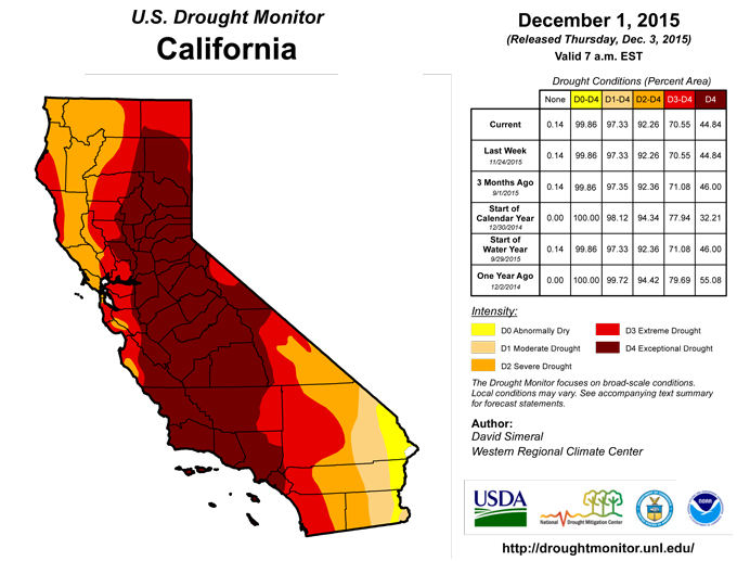
During the past week, average temperatures were well below normal across much of the West with the exception of southeastern Arizona, western New Mexico, and parts of Colorado. Elsewhere, record low temperatures were reported in California, Idaho, Oregon, Washington, and Wyoming. In the Sierras, light-to-moderate snowfall accumulations (generally less than nine inches) were observed late last week and into the weekend. Across the West, current snowpack conditions are above normal in portions of the central Sierra, Great Basin ranges, southeastern and southwestern Utah, and in areas of the southern Rockies. Below normal snowpack conditions are present in the Uintah and Wasatch of Utah, across much of the northern Rockies, and in the Cascades of Oregon and Washington. On this week’s map, improvements were made in areas of Moderate Drought (D1) in northeastern Arizona and northwestern New Mexico where drought-related conditions continue to abate as nearly all objective indicators point toward improvement. This week’s removal of the remaining area of Moderate Drought (D1) marks the first time New Mexico has been out of drought on the map since November 23, 2010. It should be emphasized, however, that the managed hydrologic systems have not fully recovered and that some of the state’s reservoirs remain below normal. In central and west-central Utah, areas of Moderate Drought (D1) and Severe Drought (D2) saw minor improvements as slow recovery in these areas continues. In central Utah, NRCS SNOTEL stations are reporting slightly above average snowpack conditions to date. In the central Rockies of Colorado, areas of Abnormally Dry (D0) were reduced as early season snowpack data supports improvement.Looking Ahead
The NWS WPC 7-Day Quantitative Precipitation Forecast (QPF) calls for significant precipitation totals (ranging from six-to-sixteen inches) in coastal northern California, Oregon, and Washington with coastal areas of Washington expected to receive the greatest accumulations. Otherwise, more meager accumulations are forecasted for the Northern Rockies of Idaho and northern portions of the Sierras; the remainder of the West will be generally dry. In the eastern tier, heaviest precipitation accumulations (one-to-four inches) are forecasted for parts of the Southeast and Mid-Atlantic. The CPC 6–10 day outlooks call for a high probability of above normal temperatures across nearly the entire continental U.S., with the exception of normal temperatures in southern New Mexico and Texas. Across most of the West, with the exception of the Pacific Northwest and extreme northern California, there is a high probably of below normal precipitation. Below normal precipitation is forecasted to extend across the Central and Northern Plains as well as across the Midwest into the Northeast. In contrast, portions of the Southeast, Southern Plains, and Texas have a high probability of above normal precipitation.Author(s):
David Simeral, Western Regional Climate Center
Dryness Categories
D0 ... Abnormally Dry ... used for areas showing dryness but not yet in drought, or for areas recovering from drought.Drought Intensity Categories
D1 ... Moderate DroughtD2 ... Severe Drought
D3 ... Extreme Drought
D4 ... Exceptional Drought
Drought or Dryness Types
S ... Short-Term, typically <6 months (e.g. agricultural, grasslands)L ... Long-Term, typically >6 months (e.g. hydrology, ecology)
Source: National Drought Mitigation Center

