


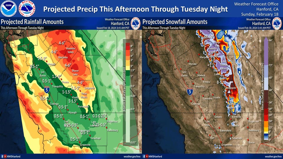
Mariposa projected rainfall: 4.00" - 6.00"
Yosemite Valley projected rainfall: 4.00" - 6.00"
February 18, 2024 - National Weather Service Hanford Office officials report a strong storm system will impact Central California this afternoon through Tuesday night, resulting in periods of heavy precipitation.
The majority of this precipitation will fall this evening through Monday evening.
The snow level will start at around 7,000 feet this afternoon, before dropping to about 6,000 feet Monday night.
Area Forecast Discussion
National Weather Service Hanford CA
403 AM PST Sun Feb 18 2024
.KEY MESSAGES...
1. An atmospheric river will impact Central California this
evening through Monday evening.
2. Excessive runoff from heavy rainfall north of Kern County
Sunday evening through Monday evening may cause mudslides and
rockslides in steep canyons and hillsides, as well as flooding
of low-lying areas.
3. Major winter storm impacts are expected in the Sierra Nevada
above 6,000 feet Sunday evening through Monday evening due to
snow amounts up to four feet.
4. Strong winds will affect portions of the San Joaquin Valley
north of Fresno, the Westside Mountains, Frazier Mountain
Communities and Grapevine area Sunday afternoon through Monday
evening.
5. A few strong thunderstorms are possible north of Kern County
Monday afternoon into Monday evening. Areas of Merced County
have been placed in a Marginal Risk for Severe Thunderstorms.
&&
.DISCUSSION...
An upper level shortwave trough will be exiting Central
California tonight, tracking east towards the Central United
States through the remainder of the weekend. This system brought
rainfall around one to two tenths of an inch to the San Joaquin
Valley Saturday afternoon with some localized areas near three
to four tenths in the Sierra Nevada foothills and along the
Coastal Range. A short period of stable conditions will build in
Sunday morning with winds aloft setting up in a zonal pattern.
This pattern looks to end Sunday afternoon due to a cut-off low
pressure disturbance approaching the region which will be
responsible for a wetter pattern over California until midweek.
The cyclonic flow around this upper low will result in winds
from the south to southwest bringing warm, moist air from the
tropics to the region. Periods of moderate to heavy rainfall are
conceivable in our forecast area Sunday night through Monday
along with heavy snowfall in the Sierra Nevada. According to NBM
guidance, there is a moderate to high probability (50-80%) for
0.5 inches or greater of rainfall for the San Joaquin Valley
north of Kern County between Sunday morning and Monday morning.
This is reflected by the Weather Prediction Center which has
placed these areas under a Marginal Risk (5-15%) for excessive
rainfall during this time period. In addition to these areas,
much of Merced County, Mariposa County, and the foothills of the
Sierra Nevada in Fresno and Madera Counties have been placed
under a Slight Risk (15-40%) for excessive rainfall. Flooding
has the potential to be a major concern for the foothills as
rainfall rates could reach one quarter of an inch per hour or
more and could lead to mudslides and rockslides in steep canyons
and hillsides.
As mentioned above, this system will continue to bring impacts
to the forecast region through midweek, and as such, the
Weather Prediction Center has continued the Marginal Risk
(5-15%) for excessive rainfall through Tuesday morning for the
San Joaquin Valley north of Kern County and included both the
San Joaquin Valley and Kern County in a Marginal Risk (5-15%)
between Tuesday and Wednesday morning. An additional Slight Risk
(15-40%) for excessive rainfall has been given for the eastern
San Joaquin Valley Monday through Tuesday morning which includes
the Sierra Nevada foothills in Mariposa, Madera, Fresno, and
Tulare Counties and includes the cities of Fresno and Visalia.
Due to this, a Flood Watch has been issued from 4 PM PST Sunday
until 10 AM PST Wednesday.
There is also convective potential with this system each day between
today and Wednesday, with thunderstorm development possible in
the north San Joaquin Valley this afternoon including Madera,
Mariposa, and Merced Counties, and the western portions of
Fresno County. This area of general thunderstorms expands
southward to include all of the valley areas north of Kern
County on Monday, according to the Storm Prediction Center. In
addition, much of Merced County has been included in a Marginal
Risk for severe weather tomorrow. There is at least a 5% chance
for damaging winds and at least a 2% chance for tornadic
development from thunderstorms in this area. Strong wind gusts
are likely (greater than 70%) in the northern San Joaquin Valley
and Coastal Range during this time period and as such, a Wind
Advisory has been issued for these areas.
Periods of moderate to heavy snowfall are expected in the Sierra Nevada
above 6,000 feet in association with the upper level system.
Snow levels over Central California will be around 6,000 feet to
start the event this evening, but will rise near 8,000 feet
Sunday night with the entrainment of warmer air from the
southwest. However, after the initial push of warmer air, levels
will begin falling Monday afternoon as the cooler air being
wrapped around the system moves over the region. Snow levels
have a high likelihood (greater than 80%) to fall below 6,000
feet Monday evening into Tuesday according to probabilistic
guidance from the NBM. Resulting snowfall totals between one and
two feet can be expected near the snow level at 6,000 to 7,000
feet with totals over four feet possible at the highest
elevations of the Sierra Nevada. Major winter storm impacts are
anticipated in the mountain areas, with the Weather Prediction
Center giving a high likelihood (greater than 80%) of impacts
including considerable disruptions to daily life, dangerous or
impossible driving conditions, and widespread closures and
disruptions to infrastructure may occur. A Winter Storm Warning
has been issued for the Sierra Nevada above 6,000 feet in
Madera, Fresno, Tulare, Mariposa, and Kern Counties and includes
the areas around Yosemite National Park.
This upper level system is anticipated to lift northward out of
the region late Wednesday, with stable conditions returning
Thursday and Friday as zonal flow builds in aloft. There are
indications that a weaker system could impact the area next
weekend, though there are discrepancies among model output with
the location and strength of this system.
&&
.AVIATION...
Expect MVFR or lower conditions through Sunday morning in and
near any precipitation. Additional heavier precipitation will
begin to spread over central California by Sunday afternoon.
&&
.AIR QUALITY ISSUES...
ISSUED: 02/17/2024 12:41
EXPIRES: 02/18/2024 23:59
On Sunday February 18 2024, Fireplace/Wood Stove Burning Status
is: No Burning Unless Registered in Fresno, Kern, and Kings
Counties. Burning Discouraged in Madera, Merced, and Tulare
Counties, and Kern (Greater Frazier Park Area) and Sequoia
National Park and Forest.
&&
.CERTAINTY...
The level of certainty for days 1 and 2 is medium.
The level of certainty for days 3 through 7 is medium.
Certainty levels include low...medium...and high. Please visit
www.weather.gov/hnx/certainty.html for additional information
and/or to provide feedback.
&&
.HNX WATCHES/WARNINGS/ADVISORIES...
Flood Watch from this afternoon through Wednesday morning for
CAZ300>312-315-317>322-324-325.
Wind Advisory from 4 PM this afternoon to 7 PM PST Monday for
CAZ300>304-308-313-317-318-335-336.
Winter Weather Advisory above 6000 feet until 10 AM PST this
morning for CAZ323-325>330.
Winter Storm Warning above 6000 feet from 4 PM this afternoon
to 4 AM PST Wednesday for CAZ323-326>331-333.
Source: NWS
