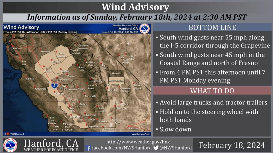
February 18, 2024 - National Weather Service Hanford Office officials report a Wind Advisory is in effect for the Interstate 5 corridor through the Grapevine, the Coastal Range, and areas north of Fresno from 4:00 P.M. this afternoon until 7:00 P.M. Monday evening.
Travel will be difficult, particularly for high profile vehicles, such as campers and tractor trailers.
Highways affected include, but are not limited to Highway 180, Highway 33, Interstate 5 through the Grapevine and north of Tranquility, Highway 152 through Pacheco Pass, and Highway 99 north of Fresno.
Wind Advisory
URGENT - WEATHER MESSAGE
National Weather Service Hanford CA
949 AM PST Sun Feb 18 2024

CAZ300>304-308-317-318-335-336-190200-
/O.CON.KHNX.WI.Y.0011.240219T0000Z-240220T0300Z/
West Side Mountains north of 198-Los Banos - Dos Palos-Merced -
Madera - Mendota-Planada - Le Grand - Snelling-Coalinga - Avenal-
West Side Mountains South of 198-Mariposa Madera Foothills-
Mariposa-Madera Lower Sierra-Grapevine-Frazier Mountain
Communities-
Including the cities of Grapevine, Frazier Park, North Fork, Lake
Mcclure, Coalinga, Blackwells Corner, Lebec, McKittrick, El
Portal, Fish Camp, Madera, Le Grand, Avenal, Merced, San Luis
Reservoir, Los Banos, Mariposa, Coarsegold, Oakhurst, Bass Lake,
Atwater, and Planada
949 AM PST Sun Feb 18 2024

...WIND ADVISORY REMAINS IN EFFECT FROM 4 PM THIS AFTERNOON TO 7 PM
PST MONDAY...

* WHAT...South winds 15 to 25 mph with gusts up to 50 mph expected.

* WHERE...Coalinga - Avenal, Frazier Mountain Communities,
  Grapevine, Los Banos - Dos Palos, Mariposa Madera Foothills,
  Mariposa-Madera Lower Sierra, Merced - Madera - Mendota, Planada -
  Le Grand - Snelling, West Side Mountains South of 198, and West
  Side Mountains north of 198.

* WHEN...From 4 PM this afternoon to 7 PM PST Monday.

* IMPACTS...Gusty winds will blow around unsecured objects. Tree
  limbs could be blown down and a few power outages may result.

PRECAUTIONARY/PREPAREDNESS ACTIONS...

Winds this strong can make driving difficult, especially for high
profile vehicles. Use extra caution.
Source: NWS


