


California and National Drought Summary for December 8, 2015
Alaska, Hawaii, and Puerto Rico
Conditions generally change little during the cold season in Alaska, and this past week was no exception, with areas of abnormal dryness persisting. In Hawaii, November was wet along the east-facing slopes, but a persistent trade wind pattern left leeward areas in the southern half of the state quite dry. Only 10 to 50 percent of normal rainfall was recorded in many leeward areas on the Big Island. This general pattern erased most of the dryness depicted last week, but prompted larger areas of D0 to be introduced in much of the leeward areas of Maui and the Big Island. Meanwhile, the eastern half of Puerto Rico recorded at least moderate rains (over 1 inch) with values generally increasing eastward. Roughly the eastern quarter of the Commonwealth reported over 2 inches of rain, with 5 to 10 inches falling on east-central sections close to the coast. As a result, the Drought Monitor depiction improved in much of the eastern one-third of the Commonwealth, which resulted in an improvement out of drought to D0 in the wettest east-central areas.Northern California and the Northwest
It was a stormy week across Idaho, Washington, Oregon, and (to a lesser extent) northern California. Heavy precipitation pounded the western half of Washington (from the Cascades to the coast) and northwestern Oregon, with more than 20 inches reported in a small part of the latter region near the coast. Along the western slopes of the Washington Cascades and a larger section of northwesternmost Oregon, 10 to locally over 15 inches prevailed. More than 5 inches fell on the northern and central Oregon Cascades, along most of the Oregon and extreme northern California coastline, and spotty areas across the Idaho Panhandle. More moderate amounts of 2 to 5 inches were common in central and northern Idaho, eastern Washington, parts of northeastern Oregon, the northern Sierra Nevada, the California Cascades, and a broader area of northwestern California from west of the Cascades to the Pacific Coast, and southward along the coast to Santa Rosa County. Lesser amounts fell on the remainder of the Northwest and northern California, but almost all areas received at least half an inch.However, an unusually small proportion of the precipitation fell as snow in the Oregon Cascades, reducing the positive impact of the heavy precipitation. Snowfall was a little more generous in the Washington Cascades, but the mountain chain in both states has less snowpack than normal for this time of year.
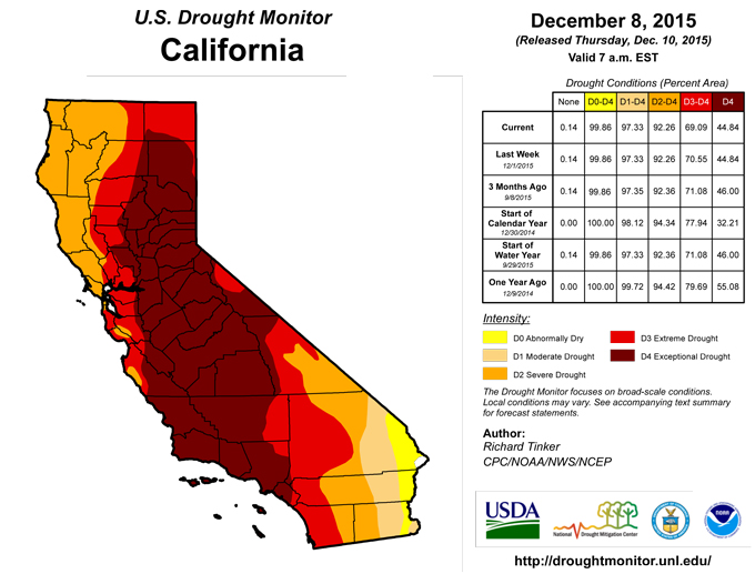
The California precipitation has produced some tangible benefits. National Agricultural Statistics Service reports say winter grain and silage is growing well, as are winter vegetables. On the east slope of the coastal range, some green-up has occurred, but not enough to bring cattle in to graze. However, the area’s multi-year drought means recovery will likely happen very slowly, and the only improvement made this week was the removal of the D3 in coastal northwestern California. Another small change was made in the southwestern Idaho Panhandle, where D3 improved to D2.
In contrast, Drought Monitor classifications improved by one category throughout northwestern Oregon, south-central Washington and adjacent Oregon, and the Washington Cascades, eliminating abnormal dryness as far southeast as Portland, OR. In a swath along the western side of the central Washington Cascades and in coastal northwestern Oregon, precipitation totals are 8 to locally 16 inches above normal. Most of the improved areas recorded a small surplus of precipitation during this period, and some orographically-favored areas, despite higher normals, are now a few inches above normal for the last 6 months.
The Great Lakes Region and Lower Ohio Valley
Although precipitation was light last week, the past 30 days brought 4 to 5 inches of precipitation to the northeastern Lower Peninsula of Michigan, and 3 to 4 inches to the Upper Peninsula of Michigan and adjacent Wisconsin. Precipitation totals have climbed above normal for the most recent 60 day period, and are near normal going back 90 days. As a result, Drought Monitor classifications improved by 1 category areawide, leaving only a small D0 area in the northwestern Upper Peninsula, which was previously in moderate drought.Farther south, moderate drought improved to D0 in a part of southwest Indiana where 30-day precipitation totals are above normal.
The Great Plains
Little if any precipitation fell last week, keeping dryness and drought unchanged in most areas. Abnormal dryness was removed from a few regions where prior precipitation eased conditions more than initially thought. Specifically, dryness was removed from southwestern Oklahoma and adjacent Texas, as well as north-central Oklahoma and adjacent Kansas. Both of these areas received 1.5 to 3.0 more precipitation than normal during the last 30 days.Only a small area in Deep South Texas deteriorated last week as the area of abnormal dryness expanded slightly. Only a few tenths of an inch of rain has fallen since early November, and observed evaporation rates have been higher than normal.
The High Plains, Rockies, Great Basin, Four Corners States, and Central and Southern California
This area covers everywhere from the High Plain westward to the Pacific Ocean, except northern California and the 3 northwesternmost states. The vast majority of this large area received little or no precipitation last week. Significant precipitation was limited to 2 areas: Northwestern Wyoming, where 0.5 to 1.5 inches of precipitation fell, and northwestern Montana, where amounts approached 3 inches in a few spots. Given how early it is in the cold (snowpack-producing) season, a week of moderate precipitation at best won’t affect conditions, and the Drought Monitor is unchanged from last week across this broad area.The Northeast, Central Appalachians, and Upper Ohio Valley
A relatively normal week left dryness and drought unchanged from last week. Generally 0.5 to 1.5 inches of precipitation fell on the Northeast. The central Appalachians were slightly wetter, receiving over 2 inches in spots, while eastern Ohio was drier, reporting only a few tenths of an inch. Since the beginning of the year, the largest deficits (12 to 16 inches) were recorded across Connecticut and small parts of adjacent New York.The South Atlantic States
During the first 8 days of December, excessively heavy rain fell on south Florida, bringing an emphatic end to the region’s dryness and drought. Miami, FL, reported 9.17 inches of rain during this period, which is almost 150% of normal for the entire December – February period (5.9 inches). This is already the wettest December since records began 105 years ago, with 23 days still to go.Farther north, between 1 and 3 inches of rain brought an end to the abnormal dryness in southwest Georgia and the adjacent Florida Panhandle. Rainfall totals in most of the region are now near or above normal for the past 60 days. In contrast, conditions have dried out farther east in northeast Florida and southeast Georgia. Over the last 90 days, 4 to 8 inches less than normal precipitation fell. The D0 area in southeast Georgia expanded slightly, but the Florida depiction was unchanged as the recent dry spell was preceded by considerably wetter conditions there.
Looking Ahead
During December 9-14, stormy weather should continue in the Northwest , bringing additional heavy precipitation to the climatologically-favored areas from the Cascades westward, as well as the Sierra Nevada. From the Washington Cascades westward, generally 2 to 5 inches of precipitation are anticipated while at least 4 inches are expected farther south into northern California. Coastal areas near the Oregon/California border should get 10 to 15 inches by mid-December. Farther east, a broad swath of moderate to heavy precipitation is forecast from the Great Lakes southwestward through much of the Mississippi Valley and eastern Texas. At least 1.5 inches are expected, with totals topping out near 5 inches in western Arkansas. Elsewhere, moderate precipitation is expected to the west and east of the wet swath in the central United States, specifically from the Plains to the Appalachians. Spotty areas in the central and northern Rockies and across Idaho can also expect moderate precipitation, with light amounts at best elsewhere.The ensuing 5 days (December 15-19) bring enhanced chances for above normal precipitation to the Northwest and the northern half of the contiguous states from the Rockies to the Atlantic Ocean. Both Florida and Alaska have increased odds for above normal precipitation as well. Odds tilting toward drier than normal conditions are limited to much of Texas and adjacent New Mexico.
Author(s):
Richard Tinker, NOAA/NWS/NCEP/CPC
Dryness Categories
D0 ... Abnormally Dry ... used for areas showing dryness but not yet in drought, or for areas recovering from drought.Drought Intensity Categories
D1 ... Moderate DroughtD2 ... Severe Drought
D3 ... Extreme Drought
D4 ... Exceptional Drought
Drought or Dryness Types
S ... Short-Term, typically <6 months (e.g. agricultural, grasslands)L ... Long-Term, typically >6 months (e.g. hydrology, ecology)
Source: National Drought Mitigation Center

