


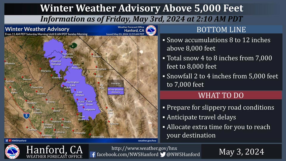
May 3, 2024 - National Weather Service Hanford Office officials report a Winter Weather Advisory remains is in effect for the Sierra Nevada above 5,000 feet from 11 AM PDT Saturday morning until 8 AM PDT Sunday morning.
The majority of this snow will fall Saturday afternoon and Saturday evening.
Wind will gust as high as 60 mph on exposed ridgetops and near the crest. Motorists should be prepared for slick road conditions and potential travel delays.
Area Forecast Discussion
National Weather Service Hanford CA
120 AM PDT Fri May 3 2024
.KEY MESSAGES...
1. The ongoing warming trend will continue today with daytime
highs rising to 4 to 7 degrees above normal.
2. A weekend storm system will bring significant snowfall to
the Sierra Nevada and rainfall to the San Joaquin Valley and
Sierra foothills as well as breezy to windy conditions across
the mountains and deserts.
3. High temperatures are forecast to cool to around 10 to 15
degrees below normal by Sunday.
4. Dry weather and a warming trend will take place Monday
through Friday.
&&
.DISCUSSION...An offshore ridge will continue to keep dry
conditions across our area today with a northwest flow aloft.
The warming trend which began yesterday will continue today with
daytime highs expected to be 4 to 7 DEG F above daily
climatological normals across our CWFA. A fairly strong onshore
gradient will provide for breezy conditions through this morning
along the Mojave Desert Slopes.
A big change will occur over the weekend as a large upper low
drops southeast out of the Gulf of AK today and into the PAC NW
and Norcal by Saturday which will bring increased clouds and
much cooler temperatures to our area. Precipitation is progged
to reach the northern portion of our CWFA by late Saturday
morning and push southward through our area Saturday afternoon
and evening. WPC QPF progs are continuing to indicate close to a
quarter inch to half inch of rain along the east side of the
San Joaquin Valley, increasing to as much as 1 to 1.25 inches of
rain higher up in the surrounding terrain below the snow line.
Up to around one tenth of an inch of rain is expected farther
west and in the south end of the San Joaquin Valley, as well as
for the Kern County mountains. Little to no precipitation is
forecast for the Kern County deserts.
Snow levels are progged to be above 8000 feet at the on set of
the precipitation on Saturday but will lower to 5000 to 6000
feet Saturday night and to 4000 to 5000 feet by the time the
precipitation ends Sunday morning. QPF progs are still
suggesting 5 to 10 inches of snowfall above 7000 feet between
midday Saturday and Sunday morning. A Winter Weather Advisory
remains in effect for the Sierra above 5000 feet for Saturday
through Sunday morning, as the expected snowfall will be
impactful to persons traveling and engaging in recreational
activities in the Sierra this weekend.
Another impact from this system will be a period of gusty winds
over the mountain ridges and in the Kern County Deserts. Latest
NBM probabilistic guidance continues to indicate a 50 to 70
percent chance of wind gusts exceeding 50 mph on Satruday night
and Sunday along the Mojave Desert slopes and across the Kern
County deserts.
Unseasonably cool temperatures will prevail across our area on
Sunday as colder air pushes into our area behind the upper low.
Daytime highs area progged to be 10 to 15 DEG F below
climatological normals. Latest NBM probabilistic guidance
indicates most of the San Joaquin Valley has a 80 to 100 percent
probability of daytime highs below 70 DEG F on Sunday.
The medium range ensemble means have converged on the idea with
an upper ridge amplifying offshore near 135W early next week
then slowly building inland through next Friday. This would
provide for dry weather across our area for next Monday through
Friday and bring a day to day warming trend with temperatures
recovering to near normal levels by Thursday and rise to above
normal by the end of next week.
&&
.AVIATION...VFR conditions will prevail across the central CA
interior for at least the next 24 hours.
&&
.AIR QUALITY ISSUES...None.
&&
.CERTAINTY...
The level of certainty for days 1 and 2 is medium.
The level of certainty for days 3 through 7 is medium.
Certainty levels include low...medium...and high. Please visit
www.weather.gov/hnx/certainty.html for additional information
and/or to provide feedback.
&&
.HNX WATCHES/WARNINGS/ADVISORIES...
Winter Weather Advisory above 5000 feet from 11 AM Saturday to
8 AM PDT Sunday for CAZ323-326.
Winter Weather Advisory above 5000 feet from 2 PM Saturday to
8 AM PDT Sunday for CAZ327>330.
Source: NWS
