


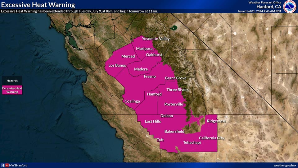
Includes Mariposa, Fresno, Madera, and Tulare Foothills and Yosemite Valley
July 2, 2024 - National Weather Service Hanford Office officials report an Excessive Heat Warning has been issued for the San Joaquin Valley, West Side Hills, Sierra Foothills, Kern River Valley and Kern County Deserts from this morning at 11:00 A.M. through Tuesday, July 9th at 8:00 A.M.
Please keep in mind to stay hydrated and cool.
Excessive Heat Warning
URGENT - WEATHER MESSAGE
National Weather Service Hanford CA
141 AM PDT Tue Jul 2 2024


West Side Mountains north of 198-Los Banos - Dos Palos-Merced -
Madera - Mendota-Planada - Le Grand - Snelling-Coalinga - Avenal-
West Side of Fresno and Kings Counties-Caruthers - San Joaquin -
Selma-Fresno-Clovis-West Side Mountains South of 198-Buttonwillow
- Lost Hills - I5-Delano-Wasco-Shafter-Hanford - Corcoran -
Lemoore-Visalia - Porterville - Reedley-Buena Vista-Bakersfield-
Southeast San Joaquin Valley-South End San Joaquin Valley-
Mariposa Madera Foothills-Mariposa-Madera Lower Sierra-Fresno-
Tulare Foothills-Fresno-Tulare Lower Sierra-South End Sierra
Foothills-South End of the Lower Sierra-Yosemite Valley-Kern
River Valley-Tehachapi-Frazier Mountain Communities-Mojave Desert
Slopes-
Including the cities of Kingsburg, Lake Isabella, San Luis
Reservoir, Coarsegold, Tehachapi, Lost Hills, Bass Lake, Lemoore
Station, Kettleman City, Fish Camp, Taft, Yosemite Valley,
Mojave, Visalia, Oakhurst, Millerton Lake, Planada, Los Banos,
Delano, Madera, Le Grand, Selma, Blackwells Corner, Tulare,
Bakersfield, Avenal, Auberry, Lemoore, Kernville, Buttonwillow,
Arvin, Corcoran, Parlier, Sanger, North Fork, McKittrick,
Shafter, Wasco, Five Points, Hanford, Coalinga, Kerman, Fresno,
Alpaugh, Atwater, Lake Mcclure, Camp Nelson, Frazier Park,
Merced, Goshen, Porterville, Lamont, Richgrove, El Portal, and
Mariposa
141 AM PDT Tue Jul 2 2024

...EXCESSIVE HEAT WARNING REMAINS IN EFFECT FROM 11 AM THIS MORNING
TO 8 AM PDT TUESDAY...

* WHAT...Dangerously hot conditions with a 50 to 90% Probability of
  high temperatures 107F or hotter. There is a 50% Probability of
  minimum temperatures of 73F or warmer. HeatRisk will be Major or
  Level 3 of 4 initially, then become Extreme, Level 4 of 4 on the
  4th of July into the weekend.

* WHERE...A portion of central California.

* WHEN...From 11 AM this morning to 8 AM PDT Tuesday.

* IMPACTS...This level of rare, long-duration extreme heat with
  little to no overnight relief affects everyone, especially those
  without effective cooling and/or adequate hydration.

* ADDITIONAL DETAILS...Impacts likely in most health systems,
  heat-sensitive industries and infrastructure.

PRECAUTIONARY/PREPAREDNESS ACTIONS...

Drink plenty of fluids, stay in an air-conditioned room, stay out of
the sun, and check up on relatives and neighbors.

Do not leave young children and pets in unattended vehicles. Car
interiors will reach lethal temperatures in a matter of minutes.

Take extra precautions when outside. Wear lightweight and loose
fitting clothing. Try to limit strenuous activities to early morning
or evening. Take action when you see symptoms of heat exhaustion and
heat stroke.

To reduce risk during outdoor work, the Occupational Safety and
Health Administration recommends scheduling frequent rest breaks in
shaded or air conditioned environments. Anyone overcome by heat
should be moved to a cool and shaded location. Heat stroke is an
emergency! Call 9 1 1.

Stay cool, stay hydrated, stay informed.
Source: NWS
