


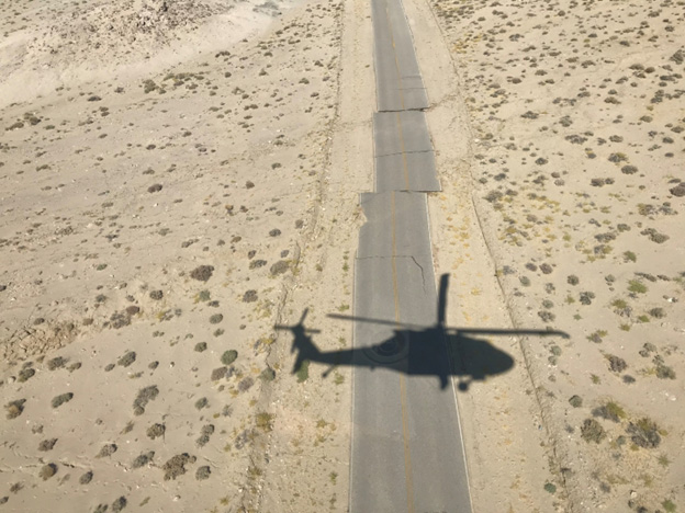
Aerial view of a road deformed by right-lateral offset along the Paxton Ranch Fault Zone near Ridgecrest.Photo credit: Michael DeFrisco, CGS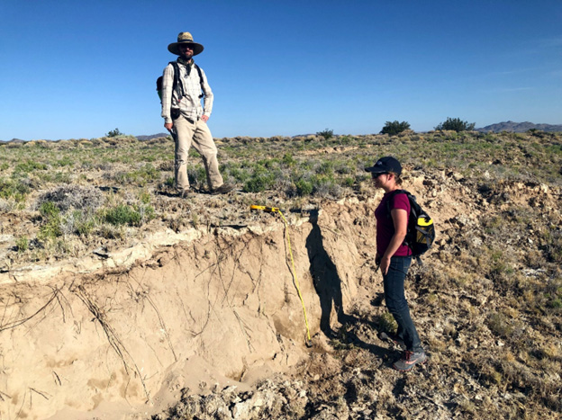
Vertical scarp on a strand of the Paxton Ranch Fault Zone, north of China Lake.
At this location the ground moved about 1 meter vertically during the July 5th, 2019 M7.1 mainshock. Photo credit: Brian Olson, CGS.
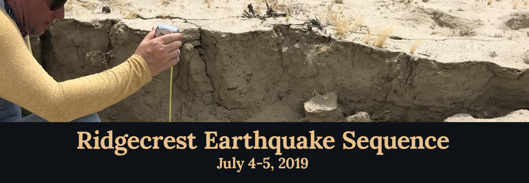
Click the image above to visit our interactive online feature: Ridgecrest Earthquake Sequence – 2019. Learn more about the scientific response in the days following the earthquakes, and view photos of surface rupture and geologists in the field.
Event Synopsis
The Ridgecrest Earthquake Sequence consisted of two earthquake events, a M6.4 foreshock on July 4th and a M7.1 mainshock on July 5th, on faults that cross each other and are now known as the Salt Wells Valley and Paxton Ranch Fault Zones, respectively. These two events occurred northeast of Ridgecrest, CA, with shaking following the events felt as far away as northern California and central Arizona. Both earthquakes had widely distributed surface effects, rupturing the ground surface along numerous fault strands and displacing the ground both vertically and horizontally (Rosa et al., 2024). Liquefaction-related deformation features and sand boils also occurred across the region as a result of the earthquakes.
The region where these earthquakes occurred is known as the southern Walker Lane, just north of the Eastern California Shear Zone (ECSZ), which helps accommodate deformation within the Pacific – North American plate boundary (Wesnousky, 2005). Notable prior historical earthquakes in the region include the 1992 Landers and Big Bear earthquakes, as well as the 1999 Hector Mine earthquake. All of these were located to the southeast of the Ridgecrest earthquakes. The immediate Ridgecrest area has previously experienced documented smaller earthquake swarms associated with minor ground cracking and displacement since the 1980s.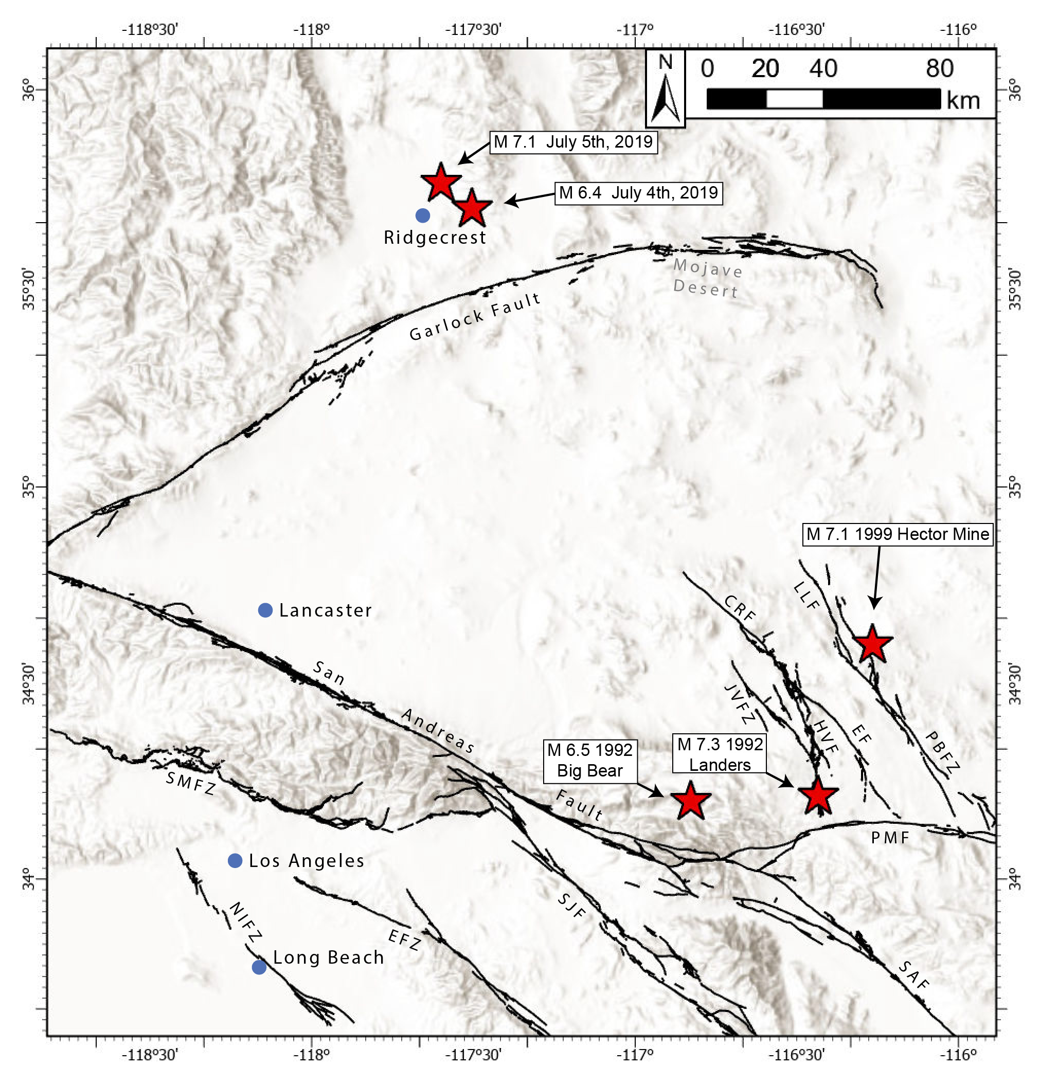 Locations of the 2019 Ridgecrest earthquakes and notable prior earthquakes (red stars). Selected major faults are also shown as black lines: Garlock Fault; San Andreas Fault (SAF); Lavic Lake Fault (LLF); Pisgah-Bullion Fault Zone (PBFZ); Camp Rock Fault (CRF); Emerson Fault (EF); Homestead Valley Fault (HVF); Johnson Valley Fault Zone (JVFZ); Pinto Mountain Fault (PMF); San Jacinto Fault (SJF); Sierra Madre Fault Zone (SMFZ); Newport-Inglewood Fault Zone (NIFZ); Elsinore Fault Zone (EFZ)
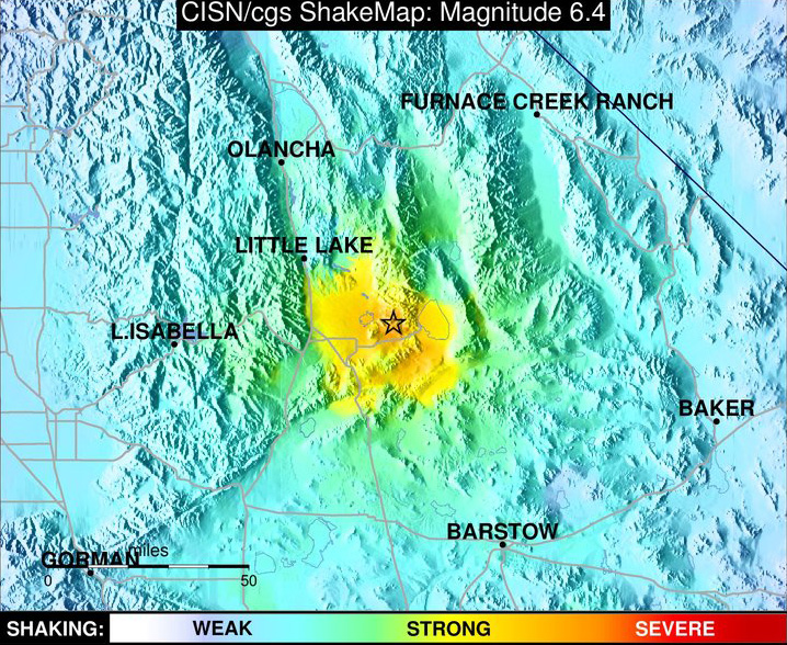
ShakeMap from the foreshock of July 4th, 2019 (M6.4).
A ShakeMap shows the relative intensity of ground shaking in the region surrounding an earthquake's epicenter. To learn more about ShakeMaps and shaking intensity, visit A Broadcaster's Guide to Reporting Earthquake Intensity. Source: California Integrated Seismic Network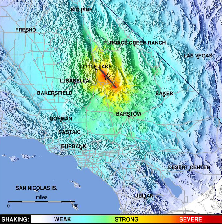
ShakeMap from the mainshock of July 5, 2019 (M7.1).
Source: California Integrated Seismic Network
Response
The Ridgecrest Earthquake Sequence provided a rare opportunity for geologists to observe and document the immediate effects of large earthquakes. The California Geological Survey (CGS) Seismic Hazard Program led the initial response to look at these faults “in the field,” along with the United States Geological Survey (USGS) and other scientific agencies and academics. Field response following the 2019 earthquakes included more than 6,000 on-the-ground site observations, of which more than 1,100 included measurements of ground offset, resulting in the mapping of over 68 km of surface rupture produced from both earthquakes (Ponti et al., 2020).
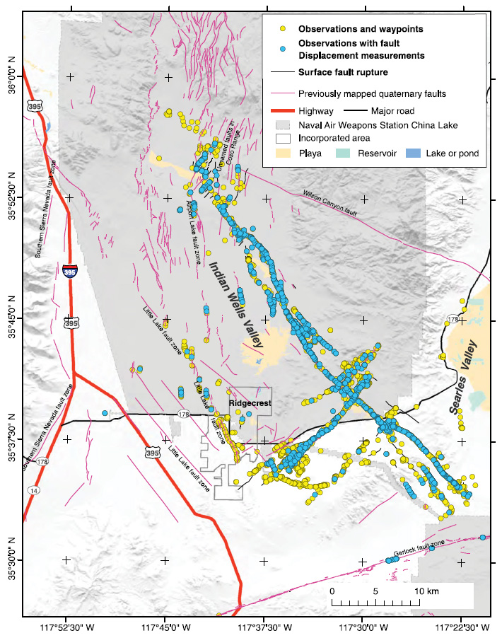
Locations of field observations compiled following the 2019 Ridgecrest Earthquakes. Magenta lines are known Quaternary-aged faults, while thin black lines are surface rupture caused by the earthquakes. Circles indicate sites where observations occurred. Blue circles are observations that include fault displacement measurements (USGS and CGS, 2024). Source: Ponti et al. (2020)
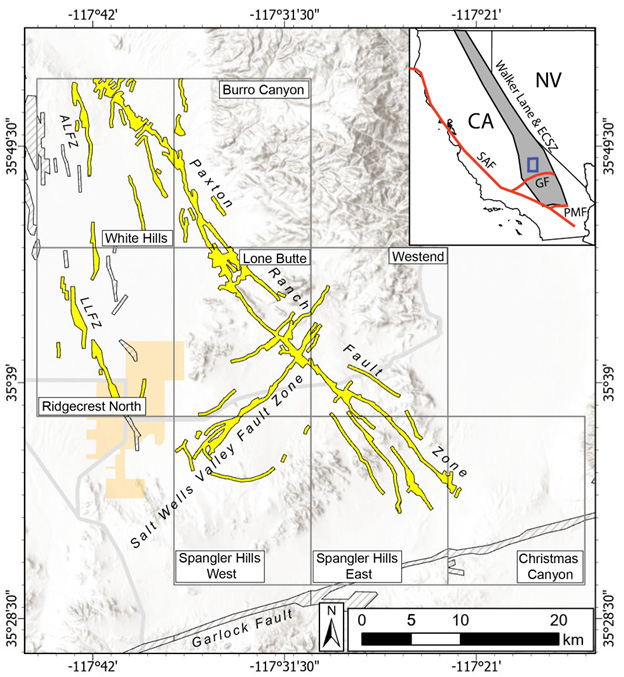
Field mapping and studies following the earthquakes show that the Salt Wells Valley Fault Zone is a mostly continuous, left-lateral fault zone that trends northeast-southwest for approximately 18 km. The largest offset along the Salt Wells Valley Fault Zone is almost 1.6 m of left-lateral movement, observed in the field southwest of the intersection with the Paxton Ranch Fault Zone (DuRoss, et al., 2020). The Paxton Ranch Fault Zone is characterized by right-lateral movement along a northwest trending, approximately 50 km long, fault zone. Right-lateral offsets observed following the M7.1 were as high as 7 m near its epicenter (DuRoss et al., 2020).
Significant Scientific Findings
The 2019 Ridgecrest Earthquake Sequence was a significant event for several reasons:
- Mapping and documentation of widespread surface rupture produced datasets that can be used for improving earthquake hazard estimates and earthquake fault zoning
- The faults of the Ridgecrest sequence intersect at ~90° (Barnhart et al., 2019), in contrast to several other historical earthquake sequences in which the causative faults merge into a single fault at depth
- Both earthquakes created widespread zones of surface deformation that were not limited to the main fault strands
- The earthquakes triggered fault creep along 20-25 km of the Garlock fault, located ~4.5 km to the south of the main Ridgecrest rupture (Barnhart et al., 2019)
CGS-Affiliated Publications

Regional map from SR 257 depicting surface rupture and ground deformation features mapped on lidar and imagery. Download the report for complete information.
CGS Special Report 257
Special Report 257 provides comprehensive documentation of surface rupture produced by the 2019 Ridgecrest Earthquake Sequence that is visible on post-earthquake lidar and imagery. The report includes pdf maps at 1:12,000 scale, in addition to online GIS map and feature services.
- Rosa, C. M., T. Dawson, and R. Kakaria (2024), Surface Rupture Mapping of the 2019 M6.4 and M7.1 Ridgecrest Earthquake Sequence on Lidar and Orthoimagery: California Geological Survey Special Report 257, 37 p.
- GIS Map Service from CGS Special Report 257
- GIS Feature Service from CGS Special Report 257
- Aerial photography from Hudnut et al.
- Lidar from Hudnut et al.
Index map of the quadrangles evaluated in FER 274, and the resulting preliminary Alquist-Priolo Earthquake Fault Zones. Download the report for complete information.
CGS Fault Evaluation Report 274
Fault Evaluation Report 274, currently in preliminary review, examines the Paxton Ranch and Salt Wells Valley fault zones within eight quadrangles for zoning under the Alquist-Priolo Earthquake Fault Zone Act.
-
DuRoss, C. B., R. D. Gold, T. E. Dawson, K. M. Scharer, K. J. Kendrick, S. O. Akciz, S. J. Angster, J. Bachhuber, S. Bacon, S. E. K. Bennett, et al. (2020). Surface Displacement Distributions for the July 2019 Ridgecrest, California, Earthquake Ruptures, Bulletin of the Seismological Society of America. 110, 1400-1418, doi: 10.1785/0120200058 -

Susan E. Hough, Eric Thompson, Grace A. Parker, Robert W. Graves, Kenneth W. Hudnut, Jason Patton, Timothy Dawson, Tyler Ladinsky, Michael Oskin, Krittanon Sirorattanakul, Kelly Blake, Annemarie Baltay, Elizabeth Cochran; Near‐Field Ground Motions from the July 2019 Ridgecrest, California, Earthquake Sequence. Seismological Research Letters 2020. 91 (3): 1542–1555. doi: https://doi.org/10.1785/0220190279 -
Hudnut, K. W., B. A. Brooks, K. Scharer, J. L. Hernandez, T. E. Dawson, M. E. Oskin, J. Ramon Arrowsmith, C. A. Goulet, K. Blake, M. L. Boggs, et al. (2020). Airborne Lidar and Electro-Optical Imagery along Surface Ruptures of the 2019 Ridgecrest Earthquake Sequence, Southern California, Seismological Research Letters. 91, 2096-2107, doi: 10.1785/0220190338 -
Ponti, D. J., J. L. Blair, C. M. Rosa, K. Thomas, A. J. Pickering, S. Akciz, S. Angster, J. P. Avouac, J. Bachhuber, S. Bacon, et al. (2020). Documentation of Surface Fault Rupture and Ground-Deformation Features Produced by the 4 and 5 July 2019 MW 6.4 and MW 7.1 Ridgecrest Earthquake Sequence, Seismological Research Letters. 91 (5): 2942-2959, doi: 10.1785/0220190322 -
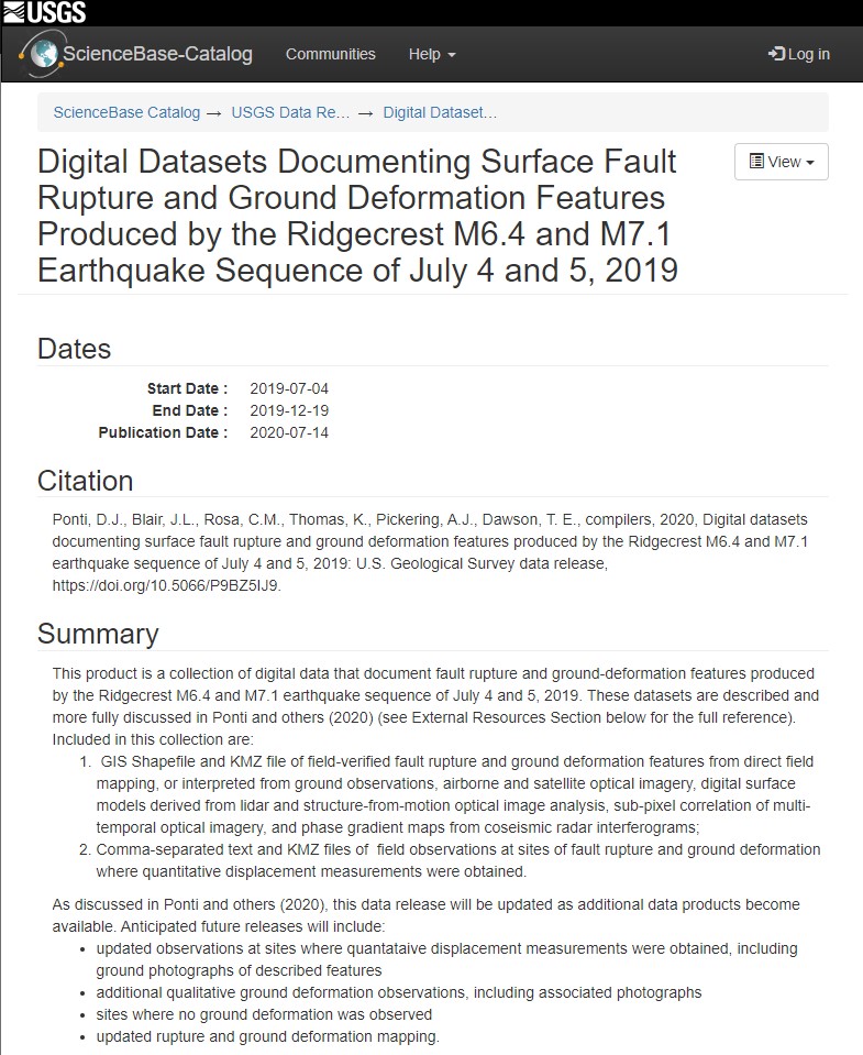 Ponti, D. J., J. L. Blair, C. M. Rosa, K. Thomas, A. J. Pickering, and T. E. Dawson, compilers (2020). Digital Datasets Documenting Surface Fault Rupture and Ground Deformation Features Produced by the Ridgecrest M6.4 and M7.1 Earthquake Sequence of July 4 and 5, 2019, U.S. Geological Survey Data Release, doi: 10.5066/P9BZ5IJ9
 -
Thompson Jobe, J. A., B. Philibosian, C. Chupik, T. Dawson, S. E. K. Bennett, R. Gold, C. DuRoss, T. Ladinsky, K. Kendrick, E. Haddon, et al. (2020). Evidence of Previous Faulting along the 2019 Ridgecrest, California, Earthquake Ruptures, Bulletin of the Seismological Society of America. 110, doi: 10.1785/0120200041
References
- Barnhart, W. D., G. P. Hayes, and R. D. Gold (2019). The July 2019 Ridgecrest, California, Earthquake Sequence: Kinematics of Slip and Stressing in Cross-Fault Ruptures, Geophysical Research Letters, 46, 11,859-11,867. https://doi.org/10.1029/2019GL084741
- DuRoss, C. B., R. D. Gold, T. E. Dawson, K. M. Scharer, K. J. Kendrick, S. O. Akciz, S. J. Angster, J. Bachhuber, S. Bacon, S. E. K. Bennett, et al. (2020). Surface Displacement Distributions for the July 2019 Ridgecrest, California, Earthquake Ruptures, Bulletin of the Seismological Society of America. 110, 1400-1418, doi: 10.1785/0120200058
- Ponti, D. J., J. L. Blair, C. M. Rosa, K. Thomas, A. J. Pickering, S. Akciz, S. Angster, J. P. Avouac, J. Bachhuber, S. Bacon, et al. (2020). Documentation of Surface Fault Rupture and Ground-Deformation Features Produced by the 4 and 5 July 2019 MW 6.4 and MW 7.1 Ridgecrest Earthquake Sequence, Seismological Research Letters. 91 (5): 2942-2959, doi: 10.1785-0220190322
- Rosa, C. M., T. Dawson, and R. Kakaria (2024), Surface Rupture Mapping of the 2019 M6.4 and M7.1 Ridgecrest Earthquake Sequence on Lidar and Orthoimagery: California Geological Survey Special Report 257, 37 p.
- U.S. Geological Survey (USGS) and California Geological Survey (CGS), Quaternary fault and fold database for the United States, accessed February 6, 2024, at: https://www.usgs.gov/natural-hazards/earthquake-hazards/faults.
- Wesnousky, S. G. (2005). Active Faulting in the Walker Lane, Tectonics, 24, doi: 10.1029/2004TC00165
Source: CA. Dept. of Conservation
