


California and National Drought Summary for January 19, 2016
Summary
Outside of the coastal ranges from northern California up to the Olympic Peninsula (along with the Sierra-Nevada), much of the rest of the Lower 48 states had a dry week. Temperatures were also much above-normal in the West and Pacific NW along with the New England region. In addition, even as the El Niño begins to weaken, its influence continues to bring more dryness and drought to the eastern islands of Hawaii.Great Plains and South
Below-normal temperatures and some additional shots of moisture across North Dakota and northern Minnesota have brought about some adjustments for this week’s map with D1 being reduced in North Dakota accompanied by a trimming of D0 in North Dakota and northern Minnesota for those areas now running around 125% of normal for the Water Year-to-date (WYTD) period (since October 1). The rest of the region remains unchanged and drought free.Hawaii, Alaska and Puerto Rico
El Niño continues to influence the drought situation across parts of Hawaii with continued dryness leading to short-term range land and vegetation impacts across more of Maui and the Big Island. As a result, D0 now covers all of Maui and the Big Island while D1 on the Big Island has now expanded to cover the lower elevation Kona slopes.Status quo is the word for Alaska and Puerto Rico this week.
Midwest
No changes are depicted on this week’s map across the Midwest as winter has things in lockdown and in pretty good shape as well with excess moisture more of a problem than too little thus far during the off-season recharge period.Southeast
Temperatures last week were quite seasonable across most of the Southeast. The best rainfall totals were confined to central Florida. This has led to a reduction of D0 in this part of the state. The northern reaches of Florida and Georgia remain unchanged and stay at D0 as the best rains stayed south and dryness (50-75% of normal) is lingering over the past 30-90-days in those areas still depicted as D0 on this week’s map. Impacts remain relatively quiet for the time being although the situation bears watching as we head toward spring and the wet season.The Northeast and Mid-Atlantic
Conditions remain unchanged this week after a relatively quiet week across the region even though temperatures ran 3-6 degrees above normal for most locales.West
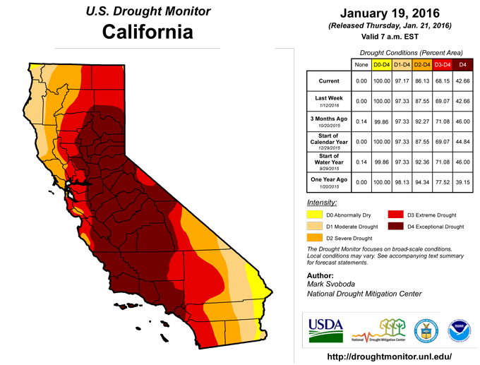
Changes abound across the region this week, but are mostly found outside of California where favorable precipitation continues to come in waves (also covering the coastal ranges from northern California up to the Olympic Peninsula in Washington) with favorable prospects for more precipitation on the horizon this week as well (see the “Looking Ahead” section below). That said, there were still some minor improvements (reduction of D0-D2) made this week in extreme northwestern California and southwestern/south-central Oregon in-and-around the Salmon Mountains, Siskiyou Mountains and Klamath region where WYTD snow water equivalents are running well above-normal thus far. This doesn’t mean the region is drought free by any means, but it’s certainly a good start to the Water Year as we sit near the mid-point of the snow season. Now we’ll see if Mother Nature finishes strong or changes her mind.The biggest improvements on this week’s map can be found in eastern/northern Nevada and across parts of eastern and northern Utah. 1-category improvement for D0-D4 was contained along the eastern flanks in both states with removal of the eastern lobe of D4 in Nevada (generally located prior in-and-around the northern reaches of the Shoshone Mountains) and the eastern lobe of D2 (generally found along the Unita Mountain range) in Utah. The D0-D2 areas were also trimmed and pushed slightly westward in both Utah and Nevada to account for the favorable pattern over the past month or so. This push of improvement to the west also includes the trimming of D0 in northern Arizona as well.
For most of the West, snowpack and snow water equivalent numbers are running above-normal to well above-normal in general. There are still some lagging totals in northern Utah and southeastern Idaho as well as in Wyoming and northwestern Montana. This issue of snow pack will be ever more important as stores of snow will hopefully continue to build as we head into the final half of the snow season, which will then be needed to begin the filling of reservoirs while also providing some buffer against the high demand that will follow come summer. The hydrological impacts (depleted streams, depleted deep soil moisture reserves, reservoirs and ground water) are the last to emerge going into drought and they will be the last to recover coming out. El Niño continues to spur on this slow recovery process (especially for those areas with the long-term “L” drought label), but much more is needed (particularly in the form of snow) to begin chipping away at the “L”, particularly in California and southern Oregon where the multi-year drought has been entrenched for some time now.
Not all areas shared in the improvement though as D0 and D1 continue to expand in western and northern Wyoming from the Big Horn range (30-50% of normal precipitation for the WYTD) west toward Yellowstone. To the north and west, improvement is noted this week in western Montana with the reduction of D0-D2 after recent storms have brought Water Year-to-date precipitation totals up to 125-200% of normal. Even so, this favorable pattern needs to continue in order to improve on the large pocket of D1-D3 found in northwestern Montana.
Looking Ahead
Over the next 5-7 days, temperatures are expected to run well above-normal (3-9 degrees) across the northern tier states from the Pacific NW to the Great Lakes. Below-normal temps are likely across the eastern Great Basin, central Rockies, central Plains, Midwest and across most of the eastern Seaboard from Florida northward into New England. As for precipitation, the best bet for the heaviest totals can be found in east-central California, northern California, and the coastal ranges of Oregon and Washington along with the Gulf Coast and Mid-Atlantic regions.The 6-10 day outlooks (January 26-30, 2016) are calling for a high probability of above-normal temperatures across the entire western half of the country (from the Mississippi River to the Pacific Ocean) with the greatest signature found along the west coast from San Diego to Seattle. Alaska and New England also seems primed to share in this winter warm spell. Precipitation is also most likely across northern California, the Pacific NW and the Great Basin with a slightly better chance of above-normal rains falling across the Southeast and central Florida in particular. Some strong pockets of dryness are most likely across the country’s mid-section including the Midwest and central/southern Plains.
Author(s):
Mark Svoboda, National Drought Mitigation Center
Dryness Categories
D0 ... Abnormally Dry ... used for areas showing dryness but not yet in drought, or for areas recovering from drought.Drought Intensity Categories
D1 ... Moderate DroughtD2 ... Severe Drought
D3 ... Extreme Drought
D4 ... Exceptional Drought
Drought or Dryness Types
S ... Short-Term, typically <6 months (e.g. agricultural, grasslands)L ... Long-Term, typically >6 months (e.g. hydrology, ecology)
Source: National Drought Mitigation Center
