


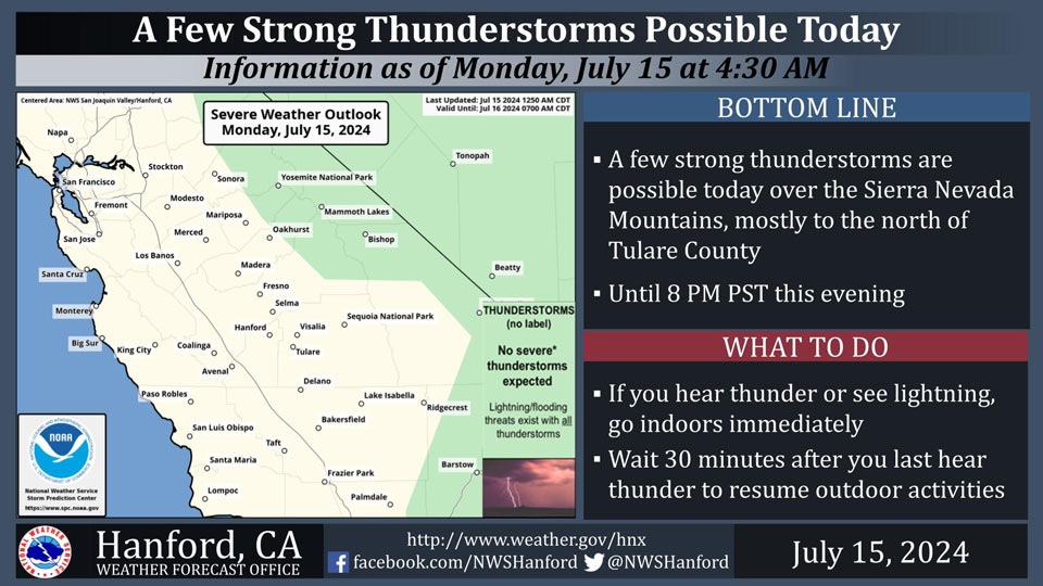
July 15, 2024 - National Weather Service Hanford Office officials report a few thunderstorms are possible in the Sierra Nevada, mostly to the north of Tulare County.
In addition to dangerous cloud to ground lightning strikes, any thunderstorm could produce small hail, gusty and erratic winds, and intense rainfall rates, leading to localized flooding.
Area Forecast Discussion
National Weather Service Hanford CA
233 AM PDT Mon Jul 15 2024
&&
.KEY MESSAGES...
1. The high risk of grass fires in the valley continues, with
fire behavior enhanced even with low wind speeds.
2. This weekend could bring another round of excessive heat to
Central California along with thunderstorms over the Sierra
Nevada.
&&
.DISCUSSION...
The dominate ridge over the entire southern CONUS is centered
over the four corners region. An upper level trough digs into
the NE Pacific sending short-waves into the Pacific NW. This
keeps most of the Golden State in slack upper flow with the
ridge continuing to enjoy visiting the Grand Canyon region
through early on Friday. Then it is a fair probability that the
ridge slides back enough to bring back the heat for the weekend.
There remains some hope in the ensemble clusters that the ridge
will be weaker to keep the 110s at bay.
For this afternoon and early evening the probability of
thunderstorms over the high Sierra is 15 to 30 percent. On the
temperature side the very slight downward trend continues with
PoE of 105 less than 15 percent in the San Joaquin Valley. In
the Kern County Desert remains over 90 percent.
Tuesday the trend of thunderstorms over the Sierra reduces down
to 5 to 15 percent. The PoE of 105, outside of the Kern County
Desert, is below 15 percent. The PoE of 100 degrees is less than
25 percent for Madera and Merced. Then 55 to 80 percent across
the rest of the San Joaquin Valley.
Wednesday through Friday brings a fairly stable pattern to the
region. Sierra thunderstorm probabilities remain fairly low.
Wednesday the PoE of 100 degrees is at it's lowest less than 25
percent with only Visalia and Bakersfield coming in at 45
percent. Then Thursday and Friday the PoE of 100 trends upward
and on Friday ranges from 55 to 70 percent for most of the
valley with the normal exceptions of Visalia and Bakersfield
that come in at 80 percent.
Saturday and Sunday the temperature trend is upward and moving
the bar up to the PoE of 105 lands probabilities at 30 to 60
percent by Sunday. The probability of thunderstorms increases to
10 to 25 percent for the Sierra Nevada. The foothills and Kern
County Desert is looking at probabilities of 5 to 15 percent.
Next Monday the upward trend in temperatures continues with PoE
of 105 degrees increasing to 40 to 75 percent for the San
Joaquin Valley and near 100 percent for the Kern County Desert.
The PoE of 110 degrees on Monday is around 65 percent for the
Kern County Desert. Bakersfield and Visalia is 10 percent.
Out beyond the standard forecast period for Wednesday the 24th
of July PoE of 110 increases to 20 to 40 percent for the San
Joaquin Valley.
&&
.AVIATION...Areas of MVFR and local mountain obscuring IFR in
showers and thunderstorms over the Sierra Nevada through 04Z
Mon. Areas of MVFR and local IFR visibility will continue in
and around wildfires. Otherwise, VFR conditions will prevail
across the central CA interior until further notice.
&&
.FIRE WEATHER...
The typical summer pattern continues with low RH and
temperatures in the upper 90s to lower 100s for the Valley and
into the 70s and 80s for higher elevations continues. Main
threats will be more thunderstorms at the higher elevations with
the peak this afternoon and trending downward for the rest of
the week. Next weekend the probability of thunder increases for
the Sierra.
&&
.AIR QUALITY ISSUES...
None.
&&
.CERTAINTY...
The level of certainty for days 1 and 2 is medium.
The level of certainty for days 3 through 7 is medium.
Certainty levels include low...medium...and high. Please visit
www.weather.gov/hnx/certainty.html for additional information
and/or to provide feedback.
&&
.HNX WATCHES/WARNINGS/ADVISORIES...
None.
Source: NWS
