


Click Here for California Fires
July 18, 2024 - Currently, 57 large active wildfires are currently being managed nationwide, and have burned 1,009,552 acres. Fire managers are using full suppression strategies on 50 of these 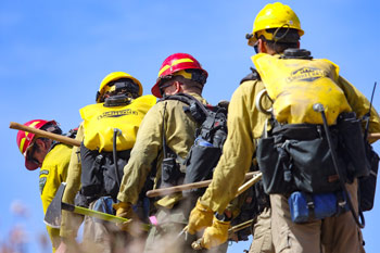 wildfires. About 19,800 wildland firefighters and support personnel are assigned to incidents, including 24 complex incident management teams and 6 Type 1 incident management teams.
Significant wildland fire activity is now occurring in most geographic areas with a high potential for additional large wildland fires to emerge. National resources like hotshot crews, airtankers, smokejumpers and communications equipment, are heavily committed and the National Interagency Coordination Center is coordinating requests for these resources with geographic area coordination centers. Active geographic areas are intensively engaged in prioritization of incidents and reallocation of resources to ensure effective incident operations. Due to these factors, the National Multi-Agency Coordinating Group increased the national preparedness level to PL 5 today.
Evacuation orders are in effect for residents near the Courgar Creek, Lone Rock, Falls, Pioneer, Larch Creek, Durkee, Lake, Texas, Bench Lake, Graff Point and Hill fires. If you live in an area that has been evacuated, please follow the instructions from local authorities. They will provide the latest recommendations based on the threat to your community and appropriate safety measures.
The Great Basin Coordination Center's predictive services staff have issued three fuels and fire behavior advisories for Nevada, Southern Idaho and Utah and Arizona Strip. There is also a fuels and fire behavior advisory in effect for California. Residents, travelers, or workers on their way to any of these states should be advised and familiarize themselves with the elevated risks.
The national predictive services staff at the National Interagency Coordination Center released the National Significant Wildland Fire Potential Outlook for July through October. For additional information about the current outlook visit the Outlook page on the NICC site.
Looking for information on a specific wildfire? Inciweb is a good place to look. If you don't see the fire you are looking for there, try contacting the local jurisdiction for information. If you are in California, it may be a CAL FIRE incident. Looking for information about air quality and smoke? Explore the national Fire and Smoke Map. An abundance of information tools are available through the National Interagency Coordination Center.
Hot, well above normal, temperatures near 100F will continue across the Inland Northwest into eastern Montana, and spread into northern Nevada, northern Utah, and the lower elevations of California. Low afternoon relative humidity below 20% will continue with poor overnight recovery below 30% in places, especially for the Inland Northwest, northern Rockies, and northern Great Basin. Locally breezy westerly winds are expected in the Cascade Gaps of northeast California, Oregon, and Washington. Isolated to scattered mixed wet and dry thunderstorms are likely on the western periphery of monsoon moisture for central and northeast Nevada into western Utah, eastern Idaho, and central Montana. Deeper monsoon moisture will move north and westward from the Southwest into southern and eastern Utah, Colorado, and portions of Wyoming for scattered mainly wet thunderstorms. Cooler conditions are expected from the Plains to the East Coast due to a cold front that will continue to move through Texas and the Southeast. Scattered to widespread showers and thunderstorms will develop along the front, especially from east Texas and the Lower Mississippi Valley through the Southeast, bringing relief to much of the Southern Area. Drier post-frontal conditions are expected to spread into the Great Lakes and Northeast, but winds are forecast to remain light. A drying trend will begin across Interior Alaska today, but temperatures will be near normal. Moderate trade winds and dry conditions will continue in Hawai’i.
| Number of new large fires or emergency response * New fires are identified with an asterisk |
9 | States currently reporting large fires: |
| Number of active large fires Total does not include individual fires within complexes. |
57 | |
| Acres from active fires | 618,190 | |
| Fires contained | 3 |
Year-to-date statistics
| 2024 (1/1/24-7/18/24) | Fires: 25,343 | Acres: 3,169,281 |
| 2023 (1/1/23-7/18/23) | Fires: 27,715 | Acres: 793,198 |
| 2022 (1/1/22-7/18/22) | Fires: 35,115 | Acres: 5,475,833 |
| 2021 (1/1/21-7/18/21) | Fires: 34,941 | Acres: 2,509,231 |
| 2020 (1/1/20-7/18/20) | Fires: 28,685 | Acres: 1,800,389 |
| 2019 (1/1/19-7/18/19) | Fires: 23,378 | Acres: 2,371,397 |
| 2018 (1/1/18-7/18/18) | Fires: 34,801 | Acres: 3,538,592 |
| 2017 (1/1/17-7/18/17) | Fires: 35,154 | Acres: 4,482,774 |
| 2016 (1/1/16-7/18/16) | Fires: 30,169 | Acres: 2,706,290 |
| 2015 (1/1/15-7/18/15) | Fires: 32,673 | Acres: 5,537,989 |
| 2014 (1/1/14-7/18/14) | Fires: 30,151 | Acres: 1,146,493 |
10-year average Year-to-Date
| 2014-2023 | Fires: 31,272 | Acres: 2,980,790 |
Source: NIFC

