


Includes Foothills of Fresno, Mariposa, Madera and Tuolumne Counties Including Yosemite
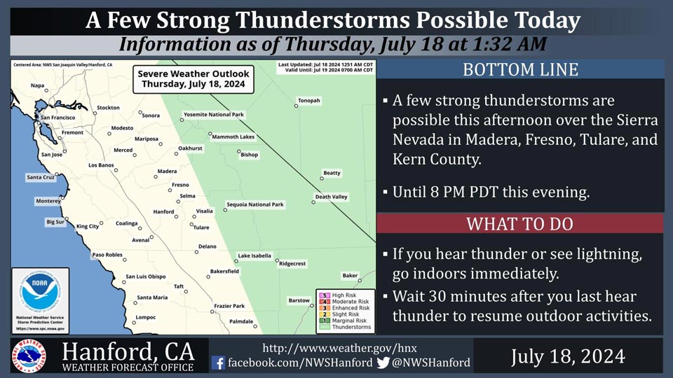
July 18, 2024 - National Weather Service Hanford Office officials report few thunderstorms are possible in the Sierra Nevada this afternoon.
Dangerous cloud to ground lightning, small hail, gusty and erratic winds, and intense rainfall rates are the main threats from these storms.
Lightning and dry grasses could ignite and spread fires.
Area Forecast Discussion
National Weather Service Hanford CA
143 AM PDT Thu Jul 18 2024
&&
.KEY MESSAGES...
1. Excessive Heat Watch in effect for the Kern County Desert and
Desert slopes beginning 11 AM Sunday and in effect for the San
Joaquin Valley, Yosemite Valley, Lake Isabella, and Sierra Nevada
foothills beginning 11 AM Monday. Both watches will go through
at least Thursday morning.
2. The high risk of grass fires in the valley continues, with fire
behavior enhanced even with low wind speeds. In the Sierra Nevada,
the risk increases with afternoon thunderstorms possible from
Thursday through Sunday.
3. Periods of afternoon thunderstorms in the Sierra Nevada continue
this week. The greatest chances will be Thursday and Friday with
a 15 to 25 percent probability. Saturday and Sunday have a 10
to 20 percent probability of thunderstorms in the Sierra Nevada.
4. There is a 30-60% chance afternoon highs reach or exceed 105*F
in the San Joaquin Valley on Monday. By Tuesday and Wednesday,
chances increase to 70-95% for afternoon highs reaching or
exceeding 105*F.
&&
.DISCUSSION...
Broader weather pattern remains mostly unchanged today vs what
we experienced yesterday. Yesterday was likely the coolest day
of the week across the San Joaquin Valley, but that isn't saying
much considering upper 90s were felt across most of the SJ Valley.
Max temperatures are forecast to gradually trend upward through
the rest of the week as high pressure currently located over
the Four Corners region begins to retrograde westward. The ridge
looks to settle over the Great Basin by early next week, so the
axis will remain a tad east of Central California. Daily rounds
of afternoon convection in the Sierra Nevada look conceivable
as well due to southerly flow over the Sierra Nevada. NBM
guidance is projecting a 25% chance of afternoon thunderstorms
for this afternoon. Confidence of a slight chance of afternoon
thunderstorms in the Sierra Nevada continue through the entire
forecast period in this flow pattern regime.
In terms of afternoon highs, we will slowly trend upwards
through this weekend. Afternoon highs across the San Joaquin
Valley are projected to reach around 105*F by Sunday.
Confidence in afternoon highs reaching or exceeding 105*F in the
SJ Valley & above 110*F in the Mojave Desert increases on
Monday due to stronger influence of the ridge of high pressure.
NBM probabilistic data show about a 30-60% chance of highs
reaching or exceeding 105*F on Monday, with those chances rising
to the 70-95% range Tuesday and Wednesday. Morning lows in the
San Joaquin Valley and Mojave desert will be quite warm as well.
So, areas of Major to Extreme HeatRisk next week are forecast.
Ensemble guidance indicates the ridge of high pressure will
still be impacting Central California by next Thursday.
Therefore, have extended the Excessive Heat Watches another 24
hours. See NPWHNX for more details. An additional extension of
the Excessive Heat Watches remains a possibility as long as
ensemble guidance continues to indicate the ridge pattern having
strong influence across Central California through next
Thursday. Perhaps some minor relief from the heat occurs
thereafter, but more model data are needed to gain confidence in
that happening.
&&
.AVIATION...
Areas of MVFR and local IFR visibility will
continue in and around wildfires. Otherwise, VFR conditions will
prevail across the central CA interior over the next 24 hours.
&&
.AIR QUALITY ISSUES...
ISSUED: 07/17/2024 14:55
EXPIRES: 07/18/2024 23:59
None.
&&
.CERTAINTY...
The level of certainty for days 1 and 2 is high.
The level of certainty for days 3 through 7 is medium.
Certainty levels include low...medium...and high. Please visit
www.weather.gov/hnx/certainty.html for additional information
and/or to provide feedback.
&&
.HNX WATCHES/WARNINGS/ADVISORIES...
Excessive Heat Watch from Sunday morning through Thursday
morning for CAZ337>339.
Excessive Heat Watch from Monday morning through Thursday
morning for CAZ300>321-324-325-332.
Source: NWS
