


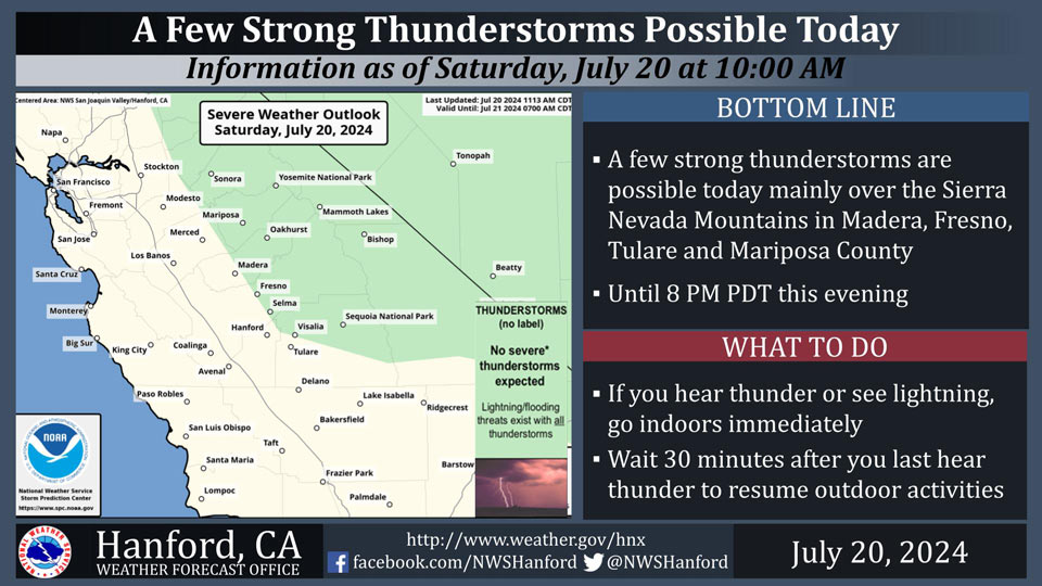
Includes Foothills of Fresno, Mariposa, Madera and Tuolumne Counties Including Yosemite
July 20, 2024 - National Weather Service Hanford Office officials report a few thunderstorms are possible in the Sierra Nevada this afternoon.
Dangerous cloud to ground lightning, small hail, gusty and erratic winds, and intense rainfall rates are the main threats from these storms.
Lightning and dry grasses could ignite and spread fires.
Area Forecast Discussion
National Weather Service Hanford CA
300 AM PDT Sat Jul 20 2024
.KEY MESSAGES...
1. An Excessive Heat Warning is in effect for the Kern County
Desert and Mojave Desert Slopes beginning 11 AM PDT Sunday and
in effect for the San Joaquin Valley, Yosemite Valley, Lake
Isabella, and Sierra Nevada foothills beginning 11 AM PDT
Monday. Both warnings are in effect through 11 PM PDT Wednesday.
2. The high risk of grass fires in the valley continues, with
enhanced fire behavior even with lower wind speeds. In the
Sierra Nevada, the risk increases with afternoon thunderstorms
possible from today through Thursday.
3. Periods of afternoon thunderstorms in the Sierra Nevada
continue through the weekend and into next week. There is a 10
to 20 percent probability each afternoon.
4. There is a 30 to 60 percent chance for afternoon highs to
reach or exceed 105 degrees in the San Joaquin Valley on Monday,
chances increase to 75 to 95 percent for Tuesday then lower to
55 to 75 percent for Wednesday and Thursday.
&&
.DISCUSSION...High pressure centered over AZ is the main
weather concern for our area today as it continues to
strengthen which will result in a continuation of the ongoing
warming trend with daytime temperatures approaching dangerous
levels once again. The other concern for today is that with a
southeast flow aloft transporting a surge of upper level
tropcial moisture into our area and sufficient instability (LI's
between -5 DEG C and -2 DEG C) and CAPE (800 to 1600 J/KG) over
the Sierra Nevada this afternoon, showers and thunderstorms
will be more prevalent today with the best chances near the
crest.
SREF is showing a shortwave pushing into the PAC NW tonight
which help push some marine cooled air into the San Joaquin
Valley on Sunday and allow for a cooling trend to take place
over the lower elevations. However, not much impact from
this will be felt over the mountains and even the Kern County
Deserts where temepratures are expected to rise to dangerous
levels with a PoE of 110 DEG F between 10 and 40 percent. The
shortwave will turn the flow aloft more southerly which will
make the Sierra NEvada less favorable for afternoon convection
on Sunday although there will be enough instability for a slight
chance of afternoon thunderstorms near the crest.
The ridge to our east is the progged to build westward into CA
on Monday and Tuesday resulting in the return of widespread
dangerous heat across our area and the onset of yet another
heat wave. The PoE for 105 DEG F in the valley rises to 30 to 60
percent on Monday and to 75 to 95 percent for Tuesday as
afternoon highs in the valley approach 110 DEG F. The ridge will
remain center just to the east of our area on Wednesday and
Thursday maintaining much above normal temperatures across our
area although daytime temperatures might be slightly cooler due
to another surge in upper level tropical moisture which could
also bring increased chances of afternoon thunderstorms over the
Sierra Nevada.
Ensemble means are showing an upper trough dropping out of the
Gulf of AK late in the week which will push into the PAC NW and
Norcal by next weekend. This will result in a significant
cooling trend across our area Friday through next weekend as
the ridge gets pushes eastward and a cooler and drier westerly
flow becomes established over central CA. By Friday, the PoE
for 105 DEG F lower to 5 to 30 percent across most of the San
Joaquin Valley and to near zero by next weekend with the PoE
for 100 DEG F in most of the valley at 20 percent or less as
temperatures lower to near normal.
&&
.AVIATION...Areas of MVFR and local mountain obscuring IFR in
showers and thunderstorms over higher elevations of the Sierra
Nevada between 18Z Sat and 03Z Sun. Areas of MVFR and local IFR
visibility will continue in and around wildfires. Otherwise, VFR
conditions will prevail across the central CA interior over the
next 24 hours.
&&
.AIR QUALITY ISSUES...None.
&&
.CERTAINTY...
The level of certainty for days 1 and 2 is high.
The level of certainty for days 3 through 7 is medium.
Certainty levels include low...medium...and high. Please visit
www.weather.gov/hnx/certainty.html for additional information
and/or to provide feedback.
&&
.HNX WATCHES/WARNINGS/ADVISORIES...
Excessive Heat Warning from 11 AM Sunday to 11 PM PDT
Wednesday for CAZ337>339.
Excessive Heat Warning from 11 AM Monday to 11 PM PDT
Wednesday for CAZ300>321-324-325-332.
Source: NWS
